Utility location

Last updated
Utility locator tool in use (Perry, Oklahoma, 2011) Using a Utility Locator.jpg
Utility locator tool in use (Perry, Oklahoma, 2011)

Utility location is the process of identifying and labeling public utility mains that are underground. These mains may include lines for telecommunication, electricity distribution, natural gas, cable television, fiber optics, traffic lights, street lights, storm drains, water mains, and wastewater pipes. In some locations, major oil and gas pipelines, national defense communication lines, mass transit, rail, and road tunnels also compete for space underground. [1]

Contents

Overview

Public utility systems are often run underground—some by the very nature of their function, others for convenience or aesthetics. In the United States, it is estimated that subsurface lines amount to over 20,000,000 miles (32,000,000 km) in total. [2] Before digging, local governments often require that the underground systems' locations be denoted and approved, if it is to be in the public right-of-way.

Pipeline markers, signs, or other indicators may or not be visible to warn of the presence of underground utilities. For various reasons, including security, the precise location of the utilities may not be indicated. The only way an excavator can know the precise location, number, and types of utilities is to contact the underground utilities coordinator, and request that the locations be marked. In most jurisdictions, there is no charge for this service, but advance notification is a legal requirement.

In the UK, to follow HSG47 [3] and PAS128 [4] guidelines, it is recommended that a Desktop Utility Search is carried out. A Utility Search, also known as a C2 Utility Search or PAS128 (D) utility search, is the initial step in identifying utility asset owners and locating their buried and overhead assets and apparatus. A Utility Search is essential for development projects as it provides valuable insight into the presence and location of underground and overhead utility assets. As well as providing a understanding of the networks within the vicinity of a site, this information can help to prevent accidents, disruptions, and costly delays during construction. [5]

Technology and equipment

Because of the many different types of materials that go into manufacturing each of the different types of underground lines, different detection and location methods must be used. The two general methods are called passive locating and active locating.

Passive locating uses signals that occur naturally on some utility lines. This method often fails to locate 60% or so of utility lines,[ citation needed ] and misidentifying utilities is an associated risk. Active locating, on the other hand, is more accurate. It makes use of signals that the locators generate through a transmitter. Then, with the help of a receiver, locators can trace as well as identify what type of utility line lies underground.

The active method is the most suitable for locating conductive metal pipes and cables. This process often involves using a piece of electromagnetic equipment, consisting of a transmitter and a receiver. For other types of pipe such as plastic or concrete, a metallic tracer wire or conductive foil (detectable tape) may be buried alongside or immediately above the pipe, to aid in locating it. In the absence of such a conductive tracer, other types of radiolocation or modern ground-penetrating radar must be used. Location by these technical means is necessary because maps often lack the pinpoint precision needed to ensure proper clearance. In older cities, it is especially a problem since maps may be very inaccurate, or may be missing entirely.

A few utilities are permanently marked with short posts or bollards, mainly for lines carrying petroleum products. This may be done because of venting requirements, and also serves to indicate the location of underground facilities that are especially hazardous if disturbed.

As of 2022, utility locators depend primarily on three types of utility locating equipment to do their job, including GPR, electromagnetic profiling locators, and radio frequency pipe locators. These tools are produced by a number of manufacturers, and are widely available throughout the world. Some of the large manufacturers include Leica, RIDGID, and Schonstedt. With advances in technology, these tools continue to improve, [6] and locators in the field are able to be more accurate.

Many utilities are now mapped out on GIS mapping services like ESRI, which improves both accuracy and process transparency. Some of the current locate wands are able to relay their information and sync up with GIS systems to expand and correct the information on the map, which helps to update the map very rapidly.

Organizations

In the US, Canada, Australia, and New Zealand, many large locate companies handle millions of tickets every dig season, [7] and need a way of managing these tickets and sending them through to a unified call center (for example, Underground Service Alert).

The Common Ground Alliance (CGA) publishes the Damage Information Reporting Tool (DIRT report) every year, which gives a fuller picture of the effects of utility locating throughout North America. In recent years, DIRT has demonstrated a trend of greater excavation damage incidents over time. [8] This report does not contain every single incident, as stakeholders voluntarily submit underground damages and near-miss reports, but it is the most complete repository of utility damages anywhere in the world. Utility Locators and other stakeholders depend on data like this to learn about risks and to justify continued investment in the industry.

Industry leaders in damage prevention like the Common Ground Alliance and IR-Saving Lives are the biggest promoters of utility locating, and encourage other stakeholders to take utility locating seriously. The CGA also has published a paper called "Insights into Improving the Delivery of Accurate, On-Time Locates",[ citation needed ] which has expert information on how to improve the locating industry in the US and Canada (not to be confused with the Canadian Common Ground Alliance (CCGA), a companion organization to CGA in Canada).

Other technologies and equipment are identified in Technology Reports by CGA [9] and in a major study by the Pipeline and Hazardous Materials Safety Administration in 2017 entitled A Study on Improving Damage Prevention Technology. [10]

Telephone hotlines

"Call before you dig", "Know What's Below! Dig With Confidence!", "Dial before you dig", "Digger's Hotline", "One-call", "Miss Utility", "Dig Safe", "Click before you dig", or Underground Service Alert are services that allow construction workers or property owners to contact utility companies, who will then denote where underground utilities are located via color-coded markings typically up to and not past the user's service connection or meter. Utility lines on the other side of the meter or service connection are considered to be part of the customer's property, and will typically not be located by these services.

Failure to call such a number ahead of time may result in a fine or even a criminal charge against a person or company, particularly if such negligence causes a major utility outage or serious accident, or an evacuation due to a gas leak. Hitting a water main may also trigger local flooding or require a boil-water advisory.

The following is a partial list of countries with one-call services for utility location:

Color-coding

Yellow spray paint indicating below-street gas utility line (New York City, 2007) GasLineMarking.jpg
Yellow spray paint indicating below-street gas utility line (New York City, 2007)
Telecommunication cable location marking
Colored flags for utility locating Colored flags for utility locating.jpg
Colored flags for utility locating
Permanent water pipeline markers in Switzerland 2012 06 17 ROK Water pipeline signs Rotkreuz.JPG
Permanent water pipeline markers in Switzerland

Utility color codes are used to identify existing underground utilities in construction areas, to protect them from damage during excavation. Colored lines, flags, or both are used to mark the location and denote the type of underground utility. A special type of spray paint dispenser, which works when the can is upside-down, is used to mark lines, often in a fluorescent color. On flags, a logo often identifies the company or municipal utility which the lines belong to.

Flags may also be an advertisement for a company which has installed an irrigation system for lawns or gardens. In this case, each sprinkler head is usually marked, so that landscaping crews will not cover or bury them with soil or sod, or damage them with tractors or other construction equipment while digging holes for trees, shrubs, or other large plants or fenceposts. This is also important because a vehicle (tractor, truck, or otherwise) can break a sprinkler or the hard-PVC pipe or joint it is mounted on, simply by driving over it, particularly on newly moved soil which is uncompacted and therefore unsupportive of such weight.

Australia

The national standard for Australia uses the following color guide: [15]

Orange electricity
Yellowgas
Bluewater
White communications
Redfire services
Creamsewerage
Purple reclaimed water
Silver/Gray steam
Brownoils, flammable liquids
Light blueair
PinkUnidentified services
Blackother liquids

Germany

Utility location markers for a fire hydrant, a drinking water line and a natural gas line in Germany Hinweisschilder fur Hydrant Wasser und Gas 102 2002.jpg
Utility location markers for a fire hydrant, a drinking water line and a natural gas line in Germany

In Germany, the colors used for temporary marking of underground utilities are not standardized like in other countries. However, permanent marker signs are used for utilities like hydrants, drinking water lines and natural gas lines. A permanent marking of cables and sewage lines is not usual if they run in the public right-of-way. The standard for permanent markers in Germany uses the following colors: [16]

White with red framefire services (hydrants, suction points etc.)
Bluedrinking water
Yellowgas
Greensewage and drain lines
Orange orhot water/steam lines for district heating
Red
White orhigh-voltage power lines and telecommunication cables
Grey
Brownlines for oil and other flammable liquids

India

India uses a convention similar to the US, for marking underground utilities such as telephone, gas, water and electricity. The system is based entirely on convention without any written standard. These markings are color-coded, and are painted by contractors onto the pavement. [17]

The main colors based on the convention are used in the same way as in the US: red for electricity, yellow for gas, and blue for water. However, other colors have other meanings. Green is used for telecommunication conduits. White is used as general communication between contractors; white is also used to note the details of road surface markings so that markings can be easily restored after the road construction is completed; a few telecommunication companies also use white color for their utility locations. Orange and other colors are used by local authorities to mark improvements and other details not related to utility locations. [17]

New Zealand

There are no legal color code requirements for buried utilities and surface markings, however a general convention is used and encouraged by the government health and safety department - Worksafe. [18]

Underground DuctSurface Marking ColorSurface Marking LetterUtility
OrangeEElectricity
YellowGGas
BlueBlueWWater
WhiteBlue
GreenPurpleTTelecommunications, commonly used by Chorus for copper and fiber optic cables.
Light GreyRedSSWaste Water / Sewer
Dark GreyPinkSWStorm Water / Drainage
RedRegional Utility Specific, commonly used by UFF for fiber optic cables.
PurpleRegional Utility Specific, known to be used by Telstra Saturn Cable Television
Light blueRegional Utility Specific, known to be used by Telstra Clear
PinkRegional Utility Specific
BlackMost commonly used for non-potable water on farms however can be an outer duct for roadside utilities.

Worksafe encourages the use of a 5mm wide or larger colored stripe to indicate the content of the black duct using one of the color codes above.

A plain black microduct or 2-pair telephone cable is often used by Chorus for premises drop cables.

United Kingdom

The national standard for the United Kingdom uses the following color guide: [19]

Red electric power lines, conduit, and cables
Orange telecommunication, alarm or signal lines
Yellowgas, oil, steam, petroleum, or other flammable material
Greensewage and drain lines
Bluedrinking water
Purple reclaimed water, irrigation, and slurry lines
Pinktemporary survey markings, unknown/unidentified facilities
Whiteproposed excavation limits or route

United States and Canada

Utility markings Utility Markings (1st Call Utility Locating).jpg
Utility markings

Canada and the United States use the American Public Works Association (APWA) Uniform Color Codes for temporary marking of underground utilities: [20] [21] [22] [23] [24] [25]

Red Electric power lines, Cables, Conduit, Lighting Cables
Orange telecommunication, alarm or signal lines, cables, conduit, Phone, Cable TV, or Fiber Optic
YellowNatural Gas, Oil, Steam, Petroleum
GreenSewer or Drainage
BlueDrinking Water
Purple Reclaimed water
Pinktemporary survey markings, unknown/unidentified facilities
Whiteproposed excavation limits or route

Some municipalities use pink paint to make lines and codes on the pavements related to required street improvements such as ramp replacement, asphalt grinding, and form injection. These markings are not directly related to utility location. [26]

See also

Related Research Articles

<span class="mw-page-title-main">Color code</span> System for displaying information by using different colors

A color code is a system for encoding and representing non-color information with colors to facilitate communication. This information tends to be categorical though may also be sequential.

<span class="mw-page-title-main">Video Graphics Array</span> Computer display standard and resolution

Video Graphics Array (VGA) is a video display controller and accompanying de facto graphics standard, first introduced with the IBM PS/2 line of computers in 1987, which became ubiquitous in the IBM PC compatible industry within three years. The term can now refer to the computer display standard, the 15-pin D-subminiature VGA connector, or the 640 × 480 resolution characteristic of the VGA hardware.

<span class="mw-page-title-main">Trench</span> Excavated channel in ground

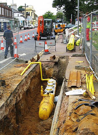
A trench is a type of excavation or depression in the ground that is generally deeper than it is wide, and narrow compared with its length.

<span class="mw-page-title-main">Color Graphics Adapter</span> IBM PC graphic adapter and display standard

The Color Graphics Adapter (CGA), originally also called the Color/Graphics Adapter or IBM Color/Graphics Monitor Adapter, introduced in 1981, was IBM's first color graphics card for the IBM PC and established a de facto computer display standard.

Electrical wiring in North America follows the regulations and standards applicable at the installation location. It is also designed to provide proper function, and is also influenced by history and traditions of the location installation.

8-1-1 is an N-1-1 telephone number in Canada and the United States. In Canada, the number is used for non-urgent health services. In the United States, 8-1-1 provides a uniform national phone number to access local utility location services.

<span class="mw-page-title-main">Electrical wiring</span> Electrical installation of cabling

Electrical wiring is an electrical installation of cabling and associated devices such as switches, distribution boards, sockets, and light fittings in a structure.

<span class="mw-page-title-main">Ground-penetrating radar</span> Geophysical method that uses radar pulses to image the subsurface

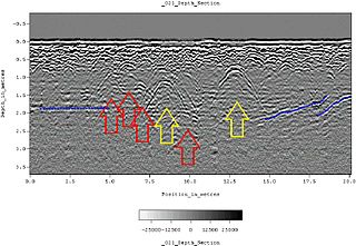
Ground-penetrating radar (GPR) is a geophysical method that uses radar pulses to image the subsurface. It is a non-intrusive method of surveying the sub-surface to investigate underground utilities such as concrete, asphalt, metals, pipes, cables or masonry. This nondestructive method uses electromagnetic radiation in the microwave band of the radio spectrum, and detects the reflected signals from subsurface structures. GPR can have applications in a variety of media, including rock, soil, ice, fresh water, pavements and structures. In the right conditions, practitioners can use GPR to detect subsurface objects, changes in material properties, and voids and cracks.

<span class="mw-page-title-main">Raised pavement marker</span> Road safety device

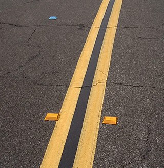
A raised pavement marker is a safety device used on roads. These devices are usually made with plastic, ceramic, thermoplastic paint, glass or occasionally metal, and come in a variety of shapes and colors. Raised reflective markers, such as plastic, ceramic, or metal ones, include a lens or sheeting that enhances their visibility by retroreflecting automotive headlights, while glass road studs gather automotive headlights with a dome shape and reflect the lights with a reflective layer within. Some other names for specific types of raised pavement markers include convex vibration lines, Botts' dots, delineators, cat's eyes, road studs, or road turtles. Sometimes they are simply referred to as "reflectors".

<span class="mw-page-title-main">Utility pole</span> Post used by public utilities to support overhead wires and related equipment

A utility pole is a column or post, usually made out of wood or aluminum alloy, used to support overhead power lines and various other public utilities, such as electrical cable, fiber optic cable, and related equipment such as transformers and street lights. It can be referred to as a transmission pole, telephone pole, telecommunication pole, power pole, hydro pole, telegraph pole, or telegraph post, depending on its application. A Stobie pole is a multi-purpose pole made of two steel joists held apart by a slab of concrete in the middle, generally found in South Australia.

<span class="mw-page-title-main">Road surface marking</span> Any kind of device or material used on a road surface to convey official information

Road surface marking is any kind of device or material that is used on a road surface in order to convey official information; they are commonly placed with road marking machines. They can also be applied in other facilities used by vehicles to mark parking spaces or designate areas for other uses. In some countries and areas, road markings are conceived as horizontal traffic signs, as opposed to vertical traffic signs placed on posts.

<span class="mw-page-title-main">Spray paint</span> Paint stored in and administered by the use of pressurized containers

Spray paint is paint that comes in a sealed, pressurized container and is released in an aerosol spray when a valve button is depressed. The propellant is what the container of pressurized gas is called. When the pressure holding the gas is released through the valve, the aerosol paint releases as a fine spray. Aerosol painting is one form of spray painting; it leaves a smooth, even coat, unlike many traditional rolled and brushed paints. Aerosol primer can be applied directly to bare metal and many plastics.

<span class="mw-page-title-main">Utility tunnel</span> Passage carrying utility lines

A utility tunnel, utility corridor, or utilidor is a passage built underground or above ground to carry utility lines such as electricity, steam, water supply pipes, and sewer pipes. Communications utilities like fiber optics, cable television, and telephone cables are also sometimes carried. One may also be referred to as a services tunnel, services trench, services vault, or cable vault. Smaller cable containment is often referred to as a cable duct or underground conduit. Direct-buried cable is a major alternative to ducts or tunnels.

In an electric power system, a fault or fault current is any abnormal electric current. For example, a short circuit is a fault in which a live wire touches a neutral or ground wire. An open-circuit fault occurs if a circuit is interrupted by a failure of a current-carrying wire or a blown fuse or circuit breaker. In three-phase systems, a fault may involve one or more phases and ground, or may occur only between phases. In a "ground fault" or "earth fault", current flows into the earth. The prospective short-circuit current of a predictable fault can be calculated for most situations. In power systems, protective devices can detect fault conditions and operate circuit breakers and other devices to limit the loss of service due to a failure.

Directional boring, also referred to as horizontal directional drilling (HDD), is a minimal impact trenchless method of installing underground utilities such as pipe, conduit, or cables in a relatively shallow arc or radius along a prescribed underground path using a surface-launched drilling rig. Directional boring offers significant environmental advantages over traditional cut and cover pipeline/utility installations. The technique is routinely used when conventional trenching or excavating is not practical or when minimal surface disturbance is required.

<span class="mw-page-title-main">Undergrounding</span> Replacement of above-ground power and telecommunications cables with underground ones

In civil engineering, undergrounding is the replacement of overhead cables providing electrical power or telecommunications, with underground cables. It helps in wildfire prevention and in making the power lines less susceptible to outages during high winds, thunderstorms or heavy snow or ice storms. An added benefit of undergrounding is the aesthetic quality of the landscape without the powerlines. Undergrounding can increase the capital cost of electric power transmission and distribution but may decrease operating costs over the lifetime of the cables.

Underground pneumatic boring is used to bore an underground hole between two points without disturbing the surface. The tools are often referred to as a hog, air hog, or pneuma gopher. This open-air chamber is referred to as the borehole and is used to either run ducting for a product or the product itself between two points.

A suction excavator or vacuum excavator is a construction vehicle that removes heavy debris or other materials from a hole on land.

<span class="mw-page-title-main">Cable locator</span> Instrument used for detecting underground cables

A cable locator or cable avoidance tool (CAT) is an instrument used for detecting the presence and approximate location of buried services in advance of undertaking excavation works. It aims to avoid accidents while excavating. A number of types of detecting technology can be employed by such instruments, including use of magnetic fields, radio frequencies, signal generation, metal detectors, ground-penetrating radar and RFID.

<span class="mw-page-title-main">Utility repair tag</span> Road patch identification marker

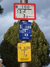
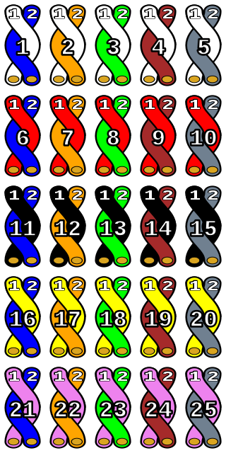
Utility repair tag is a plastic color-coded pavement marker embedded in the top surface of an asphalt utility cut restoration to identify the responsible party of that pavement repair or patch. The tag is not to be used for identification of an underground utility location.

References

  1. "USDA Utilities". USDA . Retrieved October 5, 2013.
  2. Energy, Duke. "Before digging, call 811 to avoid striking underground utility lines". Duke Energy | News Center. Retrieved 2022-07-10.
  3. https://www.hse.gov.uk/pubns/books/hsg47.htm
  4. https://www.pas128.co.uk/
  5. https://www.groundwise.com/services/utility-searches/
  6. "The History of Electromagnetic Utility Scanning". www.gp-radar.com. Retrieved 2022-06-30.
  7. "Locator Spotlight: The Lifecycle of a Locate Request | dp-PRO". dp-pro.com. Retrieved 2022-06-30.
  8. "2021 DIRT Report". dirt.commongroundalliance.com. Retrieved 2022-11-14.
  9. "Technology Reports". commongroundalliance.com. Retrieved 2022-07-10.
  10. "Report to Congress on Improving Damage Prevention Technology | PHMSA". www.phmsa.dot.gov. Retrieved 2022-07-10.
  11. "Click Before You Dig". Canadian One-Call Centres Committee and the Canadian Common Ground Alliance. Retrieved 21 October 2014.
  12. "Vault". www.roadworksscotland.gov.uk. Retrieved 2017-11-10.
  13. "Avoiding danger from underground services". Health and Safety Executive (UK). Retrieved 24 April 2017.
  14. "811. Know what's below. Call before you dig". call811.com. Common Ground Alliance. Retrieved 2013-07-24.
  15. "Dial before you dig - Working near power cables" (PDF). Energex. Retrieved 1 February 2018.
  16. "Was bedeuten die kleinen Schilder an Häusern?" (in German). t-online.de. 9 June 2021. Retrieved 20 February 2022.
  17. 1 2 Cawley, Laurence (2014-02-18). "What do those squiggles on the pavement actually mean?". BBC News . Retrieved 19 February 2014.
  18. "Guide for Safety with Underground Services - Page 29" . Retrieved 27 November 2021.
  19. "UNDERGROUND UTILITY COLOUR CODES EXPLAINED". Cornerstone Projects Ltd. Retrieved 25 July 2019.
  20. "APWA Uniform Color Code" (PDF). American Public Works Association. Retrieved 7 May 2014.
  21. "How Do I Interpret Locate Markings/ Documentation?". Dig Safe (Ontario). Retrieved 21 October 2014.
  22. "FORMS AND SAFETY TIPS". BC One Call. Retrieved 21 October 2014.
  23. "Colour code". Info-Excavation (Quebec). Retrieved 21 October 2014.
  24. "Color Code Explanation". Alberta One–Call. Retrieved 21 October 2014.
  25. "COLORS | Underground utility markings and colors". Competers Inc. 2022-01-10. Retrieved 2022-06-30.
  26. "Street Marking Explanations". City of Fort Collins. Retrieved 9 May 2014.