Valentine, Texas

Last updated

Valentine, Texas
2014-07-26 Valentine City Limit.jpg
TXMap-doton-Valentine.PNG
Location of Valentine, Texas
JeffDavis County Valentine.svg
Coordinates: 30°35′15″N104°29′44″W / 30.58750°N 104.49556°W / 30.58750; -104.49556
Country United States
State Texas
County Jeff Davis
Government
Area
[1]
  Total0.49 sq mi (1.26 km2)
  Land0.49 sq mi (1.26 km2)
  Water0.00 sq mi (0.00 km2)
Elevation
4,432 ft (1,351 m)
Population
 (2020)
  Total73
  Density148.97/sq mi (57.93/km2)
Time zone UTC-6 (Central (CST))
  Summer (DST) UTC-5 (CDT)
ZIP code
79854
Area code 432
FIPS code 48-74648 [2]
GNIS feature ID1370547 [3]

Valentine is a town in Jeff Davis County, Texas, United States. Its population was 134 at the 2010 census, [4] down from 187 at the 2000 census.

Contents

Description

The town is the only incorporated municipality in Jeff Davis County. Its name refers to the date of its founding in 1882 by a Southern Pacific Railroad construction crew: February 14. It is one of several cities named Valentine in the United States where the U.S. Postal Service cancels envelopes for Valentine's Day. [5]

The noted art installation Prada Marfa (2005) is located 1.5 miles (2.4 km) northwest of Valentine on U.S. Route 90. The Valentine resident and artist Boyd Elder (1944–2018) served as its caretaker. [6]

The John Wayne film Cahill U.S. Marshal , filmed in Durango, Mexico, was set in Valentine, Texas.

The first track of Laurel Hell by Mitski uses the town's name for its title.

Geography

Valentine is located in western Jeff Davis County at 30°35′15″N104°29′44″W / 30.58750°N 104.49556°W / 30.58750; -104.49556 (30.587504, –104.495498), [7] along U.S. Route 90. The highway leads northwest 38 miles (61 km) to Interstate 10 at Van Horn, and southeast 35 miles (56 km) to Marfa.

According to the United States Census Bureau, the town has a total area of 0.49 square miles (1.26 km2), all land. [4] The town sits in a flat basin between the Davis Mountains 15 miles (24 km) to the east and the Sierra Vieja 11 miles (18 km) to the west.

Demographics

Historical population
CensusPop.Note
1890 100
1900 14040.0%
1910 300114.3%
1920 250−16.7%
1930 629151.6%
1940 499−20.7%
1950 5102.2%
1960 420−17.6%
1970 213−49.3%
1980 32854.0%
1990 217−33.8%
2000 187−13.8%
2010 134−28.3%
2020 73−45.5%
U.S. Decennial Census [8]

2020 census

Valentine racial composition
(NH = Non-Hispanic) [9] [lower-alpha 1]
RaceNumberPercentage
White (NH)1621.92%
Asian (NH)11.37%
Mixed/Multi-Racial (NH)68.22%
Hispanic or Latino 5068.49%
Total73

As of the 2020 United States census, there were 73 people, 56 households, and 41 families residing in the town.

2000 census

As of the census [2] of 2000, there were 187 people, 72 households, and 55 families residing in the town. The population density was 388.8 inhabitants per square mile (150.1/km2). There were 138 housing units at an average density of 286.9 per square mile (110.8/km2). The racial makeup of the town was 89.84% White, 0.53% African American, 8.02% from other races, and 1.60% from two or more races. Hispanic or Latino of any race were 58.82% of the population.

There were 72 households, out of which 33.3% had children under the age of 18 living with them, 65.3% were married couples living together, 2.8% had a female householder with no husband present, and 23.6% were non-families. 22.2% of all households were made up of individuals, and 13.9% had someone living alone who was 65 years of age or older. The average household size was 2.60 and the average family size was 3.04.

In the town, the population was spread out, with 25.7% under the age of 18, 3.7% from 18 to 24, 24.6% from 25 to 44, 25.1% from 45 to 64, and 20.9% who were 65 years of age or older. The median age was 42 years. For every 100 females, there were 103.3 males. For every 100 females age 18 and over, there were 104.4 males.

The median income for a household in the town was $34,375, and the median income for a family was $38,750. Males had a median income of $22,031 versus $33,333 for females. The per capita income for the town was $16,136. About 12.8% of families and 10.7% of the population were below the poverty line, including 13.2% of those under the age of eighteen and none of those 65 or over.

Climate

Valentine experiences a semi-arid climate (Köppen BSk) with cool, dry winters and hot, dry summers.

Climate data for Valentine, Texas (1991–2020)
MonthJanFebMarAprMayJunJulAugSepOctNovDecYear
Record high °F (°C)83
(28)
87
(31)
91
(33)
98
(37)
102
(39)
108
(42)
106
(41)
103
(39)
100
(38)
96
(36)
86
(30)
80
(27)
108
(42)
Mean daily maximum °F (°C)60.8
(16.0)
66.3
(19.1)
73.3
(22.9)
81.1
(27.3)
88.6
(31.4)
94.5
(34.7)
92.3
(33.5)
91.4
(33.0)
86.6
(30.3)
79.9
(26.6)
69.3
(20.7)
61.1
(16.2)
78.8
(26.0)
Daily mean °F (°C)44.1
(6.7)
48.5
(9.2)
54.8
(12.7)
62.3
(16.8)
70.5
(21.4)
77.9
(25.5)
77.9
(25.5)
76.8
(24.9)
71.7
(22.1)
63.2
(17.3)
51.9
(11.1)
44.7
(7.1)
62.0
(16.7)
Mean daily minimum °F (°C)27.4
(−2.6)
30.7
(−0.7)
36.3
(2.4)
43.5
(6.4)
52.4
(11.3)
61.3
(16.3)
63.5
(17.5)
62.3
(16.8)
56.8
(13.8)
46.5
(8.1)
34.6
(1.4)
28.3
(−2.1)
45.3
(7.4)
Record low °F (°C)3
(−16)
−7
(−22)
12
(−11)
21
(−6)
31
(−1)
43
(6)
51
(11)
50
(10)
39
(4)
17
(−8)
8
(−13)
0
(−18)
−7
(−22)
Average precipitation inches (mm)0.63
(16)
0.43
(11)
0.37
(9.4)
0.36
(9.1)
0.71
(18)
1.76
(45)
2.40
(61)
1.36
(35)
1.75
(44)
1.20
(30)
0.57
(14)
0.58
(15)
12.12
(307.5)
Average snowfall inches (cm)1.1
(2.8)
0.0
(0.0)
0.0
(0.0)
0.0
(0.0)
0.0
(0.0)
0.0
(0.0)
0.0
(0.0)
0.0
(0.0)
0.0
(0.0)
0.0
(0.0)
0.1
(0.25)
0.3
(0.76)
1.5
(3.8)
Average precipitation days (≥ 0.001 in)2.592.192.061.633.776.197.215.064.194.001.942.5643.39
Source 1: Weather Atlas [13]
Source 2: Western Regional Climate Center, Desert Research Institute [14]

Government and infrastructure

The United States Postal Service operates the Valentine Post Office. [15] On Valentine's Day many people send postcards to Valentine, Texas. In July 2011 the USPS announced that the post office may close. [16]

Transportation

Valentine is located on US 90, 35 miles (58 km) north of Marfa, and 40 miles (64 km) south of Van Horn.

Amtrak’s Sunset Limited passes through the town on Union Pacific tracks, but makes no stop. A stop is located 60 miles (96 km) to the southeast in Alpine.

Education

Valentine Independent School District is the local district.

All of Jeff Davis County is zoned to Odessa College. [17]

Entertainment

Hi Way Cafe in Valentine, May 2013 2013-05-17 everywhere is a ghosttown here (Hi Waf Cafe, Valentine TX).jpg
Hi Way Cafe in Valentine, May 2013

Valentine is home to, as one politician puts it, "the greatest ever West Texas Valentine's Day celebration." Hosted by the Big Bend Brewing Company of Alpine, Texas, as many as 1,000 people come to Valentine on Valentine's Day from points as close as Valentine itself, Marfa, and Alpine, to places such as Chicago and Cleveland. In 2014, the west Texas brewery served free cups of beer while Gary P. Nunn played live on stage. [18]

Earthquake

On August 16, 1931, a magnitude 5.8 earthquake struck near Valentine, causing extensive damage. The earthquake was the most powerful ever recorded in Texas. [19]

See also

Related Research Articles

<span class="mw-page-title-main">Presidio County, Texas</span> County in Texas, United States

Presidio County is a county located in the U.S. state of Texas. As of the 2020 census, its population was 6,131. Its county seat is Marfa. The county was created in 1850 and later organized in 1875. Presidio County is in the Trans-Pecos region of West Texas and is named for the border settlement of Presidio del Norte. It is on the Rio Grande, which forms the Mexican border.

<span class="mw-page-title-main">Jeff Davis County, Texas</span> County in Texas, United States

Jeff Davis County is a county in the U.S. state of Texas. As of the 2020 census, its population was 1,996. Its county seat is Fort Davis. The county is named for Jefferson Davis, who served as the 23rd United States Secretary of War in the 1850s, and as Confederate president.

<span class="mw-page-title-main">Tarrant, Alabama</span> City in Alabama, United States

Tarrant is a city in Jefferson County, Alabama, bordering Birmingham to the north. At the 2020 census, the population was 6,124. It is home to the ABC Coke plant owned by the Drummond Company, "the largest single producer of foundry coke in the U.S.".

<span class="mw-page-title-main">Marathon, Texas</span> CDP in Texas, United States

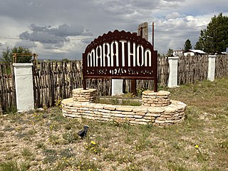
Marathon is a census-designated place (CDP) in Brewster County, Texas, United States. The population was 470 in 2007, after growing from 455 in 2000, but had decreased to 430 by 2010.

<span class="mw-page-title-main">Luling, Texas</span> City in Texas, United States

Luling is a city in Caldwell and Guadalupe counties, Texas, United States, along the San Marcos River. The population as of the 2020 census was 5,599.

<span class="mw-page-title-main">Baird, Texas</span> City in Texas, United States

Baird is a city and the county seat of Callahan County, Texas, United States. Its population was 1,479 at the 2020 census. The city is named after Matthew Baird, the owner and director of the Texas and Pacific Railway. The railway depot is now operated as the visitor center and a transportation museum.

<span class="mw-page-title-main">Hart, Texas</span> City in Castro County, Texas, United States

Hart is a city in Castro County, Texas, United States. The population was 869 at the 2020 census.

<span class="mw-page-title-main">Coleman, Texas</span> City in Texas, United States

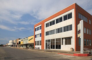
Coleman is a town in and the county seat of Coleman County, Texas, United States. As of the 2010 census, its population was 4,709.

<span class="mw-page-title-main">Paducah, Texas</span> Town in Texas, United States

Paducah is a town in Cottle County, Texas, United States. The population was 1,186 at the 2010 census, down from 1,498 in 2000. It is the county seat of Cottle County. It is just south of the Texas Panhandle and east of the Llano Estacado.

<span class="mw-page-title-main">Dickens, Texas</span> City in Texas, United States

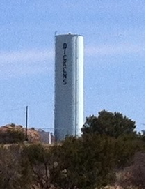
Dickens is a city in and the county seat of Dickens County, Texas, United States. The population was 286 at the 2010 census, down from 332 at the 2000 census.

<span class="mw-page-title-main">Lockney, Texas</span> Town in Texas, United States

Lockney is a town in Floyd County, Texas, United States. The population was 1,842 at the 2010 census, down from 2,056 at the 2000 census.

<span class="mw-page-title-main">Dilley, Texas</span> Town in Texas, United States

Dilley is a town in Frio County, Texas, United States. The population was 3,894 at the 2010 census. It is located off Interstate 35, south of the county seat in Pearsall.

<span class="mw-page-title-main">Pearsall, Texas</span> City in Texas, United States

Pearsall is a city in and the county seat of Frio County, Texas, United States. The population was 7,325 at the 2020 census, down from 9,146 at the 2010 census.

<span class="mw-page-title-main">Fort Davis, Texas</span> Census-designated place in Texas, United States

Fort Davis is an unincorporated community and census-designated place (CDP) in Jeff Davis County, Texas, United States. The population was 1,201 at the 2010 census, up from 1,050 at the 2000 census. It is the county seat of Jeff Davis County.

<span class="mw-page-title-main">Karnes City, Texas</span> City in Texas, United States

Karnes City is a city in and county seat of Karnes County, Texas, United States. The population was 3,111 at the 2020 census, up from 3,042 at the 2010 census. The town was named after Henry Karnes of the Texas Revolution. Karnes is 24 miles (39 km) southeast of Floresville and 54 miles (87 km) southeast of San Antonio on U.S. Highway 181.

New Deal is a U.S. town in Lubbock County, Texas. The population was 794 at the 2010 census. It is part of the Lubbock Metropolitan Statistical Area and the Llano Estacado region.

<span class="mw-page-title-main">Garrison, Texas</span> City in Texas, United States

Garrison is a small town in Nacogdoches County, Texas, United States. The population was 789 at the 2020 census.

<span class="mw-page-title-main">Marfa, Texas</span> City in Texas, United States

Marfa is a city in the high desert of the Trans-Pecos in far West Texas, United States, between the Davis Mountains and Big Bend National Park, at an elevation of 4685 feet. It is the county seat of Presidio County, and its population as of the 2020 United States Census was 1,788. The city was founded in the early 1880s as a water stop; the population peaked in the 1930s and has continued to decline each decade since. However, today Marfa is a tourist destination and a major center for minimalist art. Attractions include Building 98, the Chinati Foundation, artisan shops, historical architecture, a classic Texas town square, modern art installments, art galleries, and the Marfa lights.

<span class="mw-page-title-main">Redford, Texas</span> CDP in Texas, United States

Redford is a census-designated place (CDP) in Presidio County, Texas, United States. The population was 90 at the 2010 census.

<span class="mw-page-title-main">Shepherd, Texas</span> City in Texas, United States

Shepherd is a city in San Jacinto County, Texas, United States. The population was 2,105 at the 2020 census.

References

  1. "2019 U.S. Gazetteer Files". United States Census Bureau. Retrieved August 7, 2020.
  2. 1 2 "U.S. Census website". United States Census Bureau . Retrieved January 31, 2008.
  3. "US Board on Geographic Names". United States Geological Survey. October 25, 2007. Retrieved January 31, 2008.
  4. 1 2 "Geographic Identifiers: 2010 Census Summary File 1 (G001): Valentine town, Texas". American Factfinder. U.S. Census Bureau. Archived from the original on February 13, 2020. Retrieved December 7, 2018.
  5. Rodriguez, Lois M. (February 3, 2014). "From Valentine, With Love". Texas Highways. Archived from the original on December 22, 2017. Retrieved December 19, 2017.
  6. Cohen, Alina (May 25, 2018). "The Fake Prada Store in the Texas Desert That Became an Art Mecca". Artsy.
  7. "US Gazetteer files: 2010, 2000, and 1990". United States Census Bureau. February 12, 2011. Retrieved April 23, 2011.
  8. "Census of Population and Housing". Census.gov. Retrieved June 4, 2015.
  9. "Explore Census Data". data.census.gov. Retrieved March 5, 2022.
  10. https://www.census.gov/ [ not specific enough to verify ]
  11. "About the Hispanic Population and its Origin". www.census.gov. Retrieved May 18, 2022.
  12. "US COOP Station Map". Western Regional Climate Center, Desert Research Institute . Retrieved May 3, 2015.
  13. "Valentine, Texas, USA - Monthly weather forecast and Climate data". NOAA. Retrieved October 26, 2021.
  14. "VALENTINE, TEXAS (419270), Period of Record Monthly Climate Summary". Western Regional Climate Center, Desert Research Institute. Retrieved May 3, 2015.
  15. "Post Office™ Location - VALENTINE." United States Postal Service. Retrieved on July 26, 2011. "311 W CALIFORNIA AVE VALENTINE, TX"
  16. Weisman, Laura. "Nine Houston post offices marked for closure (with poll)." Houston Chronicle . July 26, 2011. Retrieved on July 26, 2011.
  17. "Sec. 130.193. ODESSA COLLEGE DISTRICT SERVICE AREA".
  18. "Ramón Rentería: Valentine had its day on Valentine's Day" . Retrieved February 17, 2014.
  19. "Historic Earthquakes: Near Valentine, Texas". United States Geological Survey. January 30, 2009. Retrieved January 15, 2010.
  1. Note: the US Census treats Hispanic/Latino as an ethnic category. This table excludes Latinos from the racial categories and assigns them to a separate category. Hispanics/Latinos can be of any race. [10] [11]