Valley View Leasing and Mining Company Mill

Last updated
Valley View Leasing and Mining Company Mill
Matterhorn Mill 07 19 11 208000.jpeg
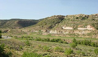
Mill building in 2023
USA Colorado location map.svg
Red pog.svg
Location State Highway 145, 2.8 miles south of Ophir, Colorado
Coordinates 37°50′57″N107°53′05″W / 37.84917°N 107.88466°W / 37.84917; -107.88466 (Valley View Leasing and Mining Company Mill) Coordinates: 37°50′57″N107°53′05″W / 37.84917°N 107.88466°W / 37.84917; -107.88466 (Valley View Leasing and Mining Company Mill)
Arealess than one acre
Built1920
Built byOtto Beselack
ArchitectWalter L. Reed
MPS Mining Industry in Colorado, MPS
NRHP reference No. 10000035 [1]
Added to NRHPFebruary 24, 2010

The Valley View Leasing and Mining Company Mill, also known as the Matterhorn Mill, near Ophir, Colorado, is a flotation mill which was built in 1920 and was renovated in 1961. [2] It was listed on the National Register of Historic Places in 2010. [1]

Contents

It is 146 by 46 feet (45 m × 14 m) in plan and 96 feet (29 m) tall. [2]

The mill is located in the valley of the Lake Fork of the San Miguel River at an elevation of 9,431 feet, and at the base of the east slope of 11,845 foot high San Bernardo Mountain in the Trout Lake Mining District just north of Lizard Head Pass. The mill is located approximately 30 degrees from true north, however, the following description refers to nominal directions. Thus, the structure extends roughly 146 feet east to west and 46 feet north to south. At its highest point at the east, the mill is ninety-six feet in height and is visible above the surrounding forest from the highway. To the west, the 146-foot long mill extends down a west slope in five steps to the mill tailings pond located on what was a bench above the Lake Fork of the San Miguel River. The area around the mill is forested, though to the east it is sparse within the 150-foot setback from the highway. Access is by a circular roadway system that connects to the highway north and south of the mill site. The dirt access road leads to the 1960s storage bin of the mill. Beyond is the original grade of the abandoned Rio Grande Southern Railroad spur that extended 200 feet northerly from the Matterhorn Depot across the east elevation of the mill and terminating at the northeast corner according to the 1922 Sanborn Map. The spur passed through a rock cut constructed in 1919 in preparation for the construction of the mill. The Sanborn Map also noted that the mill was electrified, steam heated, and supplied with water from the nearby “creek” that was stored in a 10,000 gallon tank located on the hillside above the mill. [2]

Designated a San Miguel County Landmark December 16, 2005, the Matterhorn Mill was typical of the first generation of flotation mills used to concentrate ores prior to shipment to distant smelters for final processing. The Matterhorn Mill included the four systems of a typical mill, as described in period texts, such as Antoine Marc Gaudin's Flotation (New York: McGraw Hill, 1932): 1) an ore delivery system, 2) a crushing and storage section, 3) the concentration section, and 4) filtration and bagging/shipping section. Typical of a flotation mill, the ore from the mine traveled down through fifteen levels to be reduced into concentrates. The levels augmented the economical processing of ore utilizing gravity. Nearly all the equipment remaining in the mill clearly illustrates the flotation process. [2]

It was designed by Walter L. Reed and was built by Otto Beselack. [3]

In 2009 it was owned by the U.S. Forest Service. [2]

In 2020, at 100 years of age, it was announced that the mill was "undergoing a restoration project that will stabilize the remaining architecture, improve the structural integrity and cleanup the mining waste and tailings piles. Following the completion of the mill repairs and cleanup, a historic preservation easement will facilitate the conveyance of the mill from the U.S. Forest Service to San Miguel County to sustain the Matterhorn Mill for public enjoyment and education." [3]

It is located off Colorado State Highway 145, about 2.8 miles (4.5 km) south of Ophir, within what was the historic townsite of Matterhorn, Colorado, which was known as San Bernardo, Colorado before 1908. [2]

See also

Related Research Articles

<span class="mw-page-title-main">Telluride, Colorado</span> Town in Colorado, United States

Telluride is the county seat and most populous town of San Miguel County in the southwestern portion of the U.S. state of Colorado. The town is a former silver mining camp on the San Miguel River in the western San Juan Mountains. The first gold mining claim was made in the mountains above Telluride in 1875, and early settlement of what is now Telluride followed. The town was founded in 1878 as "Columbia", but due to confusion with a California town of the same name, was renamed Telluride in 1887 for the gold telluride minerals found in other parts of Colorado. These telluride minerals were never found near Telluride, but the area's mines for some years provided zinc, lead, copper, silver, and other gold ores.

<span class="mw-page-title-main">Leadville, Colorado</span> City in Colorado, United States

The City of Leadville is a statutory city that is the county seat, the most populous community, and the only incorporated municipality in Lake County, Colorado, United States. The city population was 2,602 at the 2010 census and an estimated 2,762 in 2018. It is situated at an elevation of 10,158 feet (3,096 m). Leadville is the highest incorporated city in the United States and it is surrounded by two of the tallest 14,000 foot peaks in the state.

<span class="mw-page-title-main">San Miguel County, Colorado</span> County in Colorado, United States

San Miguel County is a county located in the U.S. state of Colorado. As of the 2020 census, the population was 8,072. The county seat is Telluride. The county is named for the San Miguel River.

<span class="mw-page-title-main">Dolores County, Colorado</span> County in Colorado, United States

Dolores County is a county located in the U.S. state of Colorado. As of the 2020 census, the population was 2,326. The county seat is Dove Creek.

<span class="mw-page-title-main">Ophir, Colorado</span> Town in San Migel County, Colorado, United States

The historic mining town of Ophir is a home rule municipality governed by a general assembly and is located in San Miguel County, Colorado, United States. Ophir is located two miles from the Ames Hydroelectric Generating Plant, the world's first hydroelectric plant to supply alternating current electricity for an industrial purpose (mining). The population was 159 at the United States Census, 2010 census.

<span class="mw-page-title-main">Comstock Lode</span> Lode of silver ore in Virginia City, Nevada

The Comstock Lode is a lode of silver ore located under the eastern slope of Mount Davidson, a peak in the Virginia Range in Virginia City, Nevada, which was the first major discovery of silver ore in the United States and named after American miner Henry Comstock.

<span class="mw-page-title-main">Uravan, Colorado</span> Uranium mining ghost town in Montrose County, Colorado

Uravan is a former uranium mining town in western Montrose County, Colorado, United States, which still appears on some maps. The town was a company town established by U. S. Vanadium Corporation in 1936 to extract the rich vanadium ore in the region. As a byproduct of vanadium extraction, small amounts of uranium were also produced, at the time mostly used as a yellow pigment for ceramics.

<span class="mw-page-title-main">Uncompahgre National Forest</span> National Forest in western Colorado, United States

Uncompahgre National Forest is a U.S. National Forest covering 955,229 acres in parts of Montrose, Mesa, San Miguel, Ouray, Gunnison, Hinsdale, San Juan, and Delta Counties in western Colorado. Its headquarters are in Delta County, in the city of Delta. It borders the San Juan National Forest to the south.

The San Juan Skyway Scenic and Historic Byway is a 236-mile (380 km) All-American Road, National Forest Scenic Byway, and Colorado Scenic and Historic Byway located in Dolores, La Plata, Montezuma, San Juan, and San Miguel counties, Colorado, USA. The byway forms a loop in southwestern Colorado traversing the heart of the San Juan Mountains. The San Juan Skyway reaches its zenith at Red Mountain Pass at elevation 11,018 feet (3,358 m). Mesa Verde National Park was one of the original UNESCO World Heritage Sites. The Silverton Historic District and the Telluride Historic District are National Historic Landmarks.

<span class="mw-page-title-main">Placerville, Colorado</span> Census-designated place in San Miguel County, Colorado, United States

Placerville is a census-designated place (CDP) and post office in and governed by San Miguel County, Colorado, United States. The Placerville post office has the ZIP Code 81430. At the United States Census 2010, the population of the 81430 ZIP Code Tabulation Area was 727 including adjacent areas.

<span class="mw-page-title-main">Atlanta, Idaho</span> Unincorporated community in the state of Idaho, United States

Atlanta is an unincorporated community in the western United States, located in Elmore County, Idaho.

<span class="mw-page-title-main">Lizard Head</span> Mountain in Colorado, United States

Lizard Head is a mountain summit in the San Miguel Mountains range of the Rocky Mountains of North America. The 13,119-foot (3,999 m) thirteener is located in the Lizard Head Wilderness, 6.8 miles (11.0 km) west by south of the Town of Ophir, Colorado, United States, on the drainage divide separating San Juan National Forest and Dolores County from Uncompahgre National Forest and San Miguel County.

<span class="mw-page-title-main">Shenandoah-Dives Mill</span> United States historic place

The Shenandoah-Dives Mill or Mayflower Mill is an intact and functional but inactive historic ore mill 2 miles (3.2 km) east of Silverton, Colorado, United States. The mill was built in 1929 to recover gold, silver, lead, zinc, and copper from ore mined at the Mayflower mine and brought to the mill by an aerial tramway. Regularly active until 1945, it houses still-functional equipment for the separation by flotation of metals from crushed ores. It is the only intact and functional mill of its kind in Colorado. It was included in the expanded Silverton Historic District in 1997, and was declared a National Historic Landmark on its own in 2000. The mill is owned by the San Juan County Historic Society, which staffs an information and gift shop at the mill under the name Mayflower Mill. The mill is open for self-guided tours in the summer months.

<span class="mw-page-title-main">Telluride Historic District</span> Historic district in Colorado, United States

The Telluride Historic District encompasses a significant portion of the developed area of the former mining boom town of Telluride, Colorado. Telluride was founded in 1878, and was a major metals mining center until 1913. The historic district covers 80 acres (32 ha) of downtown Telluride and surrounding residential areas, as well as Lone Tree Cemetery, the town's first cemetery. It was declared a National Historic Landmark in 1961 for its well-preserved late boom-town architecture.

<span class="mw-page-title-main">Henderson molybdenum mine</span> USA molybdenum mine

The Henderson molybdenum mine is a large underground molybdenum mine west of the town of Empire in Clear Creek County, Colorado, USA. The Henderson mine, which has produced molybdenum since 1976, is owned by Freeport-McMoRan.

<span class="mw-page-title-main">Holden/Marolt Mining and Ranching Museum</span> United States historic place

The Holden/Marolt Mining and Ranching Museum is located on the former Holden Mining and Smelting Company facility on the western edge of the city of Aspen, Colorado, United States. It consists of one remaining building and the remains of some others. In 1990 it was recognized as a historic district and listed on the National Register of Historic Places, the only district in the city to be so recognized.

<span class="mw-page-title-main">Fort Peabody</span> United States historic place

Fort Peabody was a military post in southwestern Colorado, situated at 13,365 feet elevation on the county line between Ouray and San Miguel Counties, making it the highest historical post of its kind in the United States. It was added to the National Register of Historic Places on March 30, 2005 as significant to the state and nation's labor history.

<span class="mw-page-title-main">Lewis Mill (Telluride, Colorado)</span> United States historic place

The Lewis Mill, near Telluride, Colorado, was built in 1910. It was listed on the National Register of Historic Places in 2009.

<span class="mw-page-title-main">Trout Lake (Colorado)</span> Body of water

Trout Lake is a lake located in southeast San Miguel County, Colorado, in Uncompahgre National Forest. Trout Lake is a 15-minute drive from Ophir via Colorado State Highway 145 and a 30-minute drive from Telluride.

<span class="mw-page-title-main">Sheep Mountain (San Miguel and Dolores Counties, Colorado)</span>

Sheep Mountain is a 13,188-foot-elevation (4,020-meter) mountain summit located on the shared boundary of Dolores County with San Miguel County, in southwest Colorado, United States. It is situated three miles south of Trout Lake and two miles southeast of Lizard Head Pass, on land managed by San Juan National Forest and Uncompahgre National Forest. Sheep Mountain is part of the San Juan Mountains which are a subset of the Rocky Mountains, and is west of the Continental Divide. Topographic relief is significant as the southwest aspect rises 3,200 feet above the Dolores River in approximately 2.5 miles. Neighbors include Golden Horn and Vermilion Peak to the east, and Lizard Head to the northwest. Sheep Mountain can be seen from the San Juan Skyway in the Lizard Head Pass and Trout Lake areas. The mountain's name, which has been officially adopted by the United States Board on Geographic Names, was in use in 1906 when Henry Gannett published it in A Gazetteer of Colorado.

References

  1. 1 2 "National Register Information System". National Register of Historic Places . National Park Service. November 2, 2013.
  2. 1 2 3 4 5 6 Rodd L. Wheaton (November 2009). "National Register of Historic Places Registration: Valley View Leasing and Mining Company Mill / Matterhorn Mill / 5SM.6717". National Park Service . Retrieved May 4, 2022. With accompanying pictures
  3. 1 2 "Matterhorn Mill celebrates 100 years". Delta County Independent. September 16, 2020. The same text, as a press release, at US Forest Service: "Matterhorn Mill celebrates 100 years".