Vander, North Carolina

Last updated
Vander, North Carolina
Vander.JPG
The welcome sign for Vander
Cumberland County North Carolina incorporated and unincorporated areas Vander highlighted.svg
Location in Cumberland County and the state of North Carolina.
Coordinates: 35°1′54″N78°47′30″W / 35.03167°N 78.79167°W / 35.03167; -78.79167 Coordinates: 35°1′54″N78°47′30″W / 35.03167°N 78.79167°W / 35.03167; -78.79167
Country United States
State North Carolina
County Cumberland
Area
[1]
  Total3.72 sq mi (9.63 km2)
  Land3.71 sq mi (9.61 km2)
  Water0.01 sq mi (0.02 km2)
Elevation
125 ft (38 m)
Population
 (2020)
  Total1,388
  Density374.22/sq mi (144.49/km2)
Time zone UTC-5 (Eastern (EST))
  Summer (DST) UTC-4 (EDT)
ZIP code
28301
Area codes 910, 472
FIPS code 37-69740 [2]
GNIS feature ID0996587 [3]

Vander is an unincorporated community and census-designated place (CDP) in Cumberland County, North Carolina, United States. The population was 1,388 at the 2020 census. [4]

Contents

Geography

Vander is located near the geographic center of Cumberland County at 35°1′54″N78°47′30″W / 35.03167°N 78.79167°W / 35.03167; -78.79167 (35.031546, -78.791628). [5] It is located just east of the city of Fayetteville (the Cumberland County seat) and just south of the town of Eastover. Interstate 95 forms the western edge of Vander; it intersects North Carolina Highway 24 at Exit 52 at the northwestern corner of the community, but there is no direct access to Vander, as Highway 24 is a limited-access highway at this point.

According to the United States Census Bureau, the CDP has a total area of 3.7 square miles (9.7 km2), of which 0.01 square miles (0.02 km2), or 0.21%, is water. [4]

Demographics

Historical population
CensusPop.Note
2020 1,388
U.S. Decennial Census [6]

As of the 2000 census, [2] there were 1,204 people, 479 households, and 348 families residing in the CDP. The population density was 315.8 people per square mile (122.0/km2). There were 527 housing units at an average density of 138.2 per square mile (53.4/km2). The racial makeup of the CDP was 69.44% White, 24.92% African American, 2.08% Native American, 1.00% Asian, 0.08% Pacific Islander, 0.58% from other races, and 1.91% from two or more races. Hispanic or Latino of any race were 1.83% of the population.

There were 479 households, out of which 29.6% had children under the age of 18 living with them, 53.2% were married couples living together, 13.4% had a female householder with no husband present, and 27.3% were non-families. 24.2% of all households were made up of individuals, and 9.4% had someone living alone who was 65 years of age or older. The average household size was 2.51 and the average family size was 2.95.

In the CDP, the population was spread out, with 25.2% under the age of 18, 8.3% from 18 to 24, 30.7% from 25 to 44, 23.9% from 45 to 64, and 11.9% who were 65 years of age or older. The median age was 36 years. For every 100 females, there were 96.4 males. For every 100 females age 18 and over, there were 90.9 males.

The median income for a household in the CDP was $40,260, and the median income for a family was $44,167. Males had a median income of $32,750 versus $23,250 for females. The per capita income for the CDP was $19,059. About 8.7% of families and 9.1% of the population were below the poverty line, including 12.1% of those under age 18 and 13.2% of those age 65 or over.

Related Research Articles

<span class="mw-page-title-main">Kalaoa, Hawaii</span> Census-designated place in Hawaii, U.S.

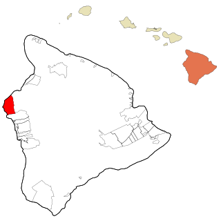
Kalaoa is a census-designated place (CDP) in Hawaiʻi County, Hawaiʻi, United States. The population was 9,644 as of the 2010 census, up from 6,794 residents at the 2000 census.

<span class="mw-page-title-main">Cresaptown-Bel Air, Maryland</span> Former census-designated place in Maryland, United States

Cresaptown-Bel Air was a census-designated place in Allegany County, Maryland, United States. The population was 5,884 at the 2000 census. For the 2010 census, the area was separated into two CDPs, Cresaptown and Bel Air.

<span class="mw-page-title-main">LaVale, Maryland</span> Census-designated place in Maryland, United States

LaVale is a census-designated place (CDP) in Allegany County, Maryland, United States. It is part of the Cumberland, MD-WV Metropolitan Statistical Area. The population was 3,551 at the 2010 census.

<span class="mw-page-title-main">Deale, Maryland</span> Census-designated place in Maryland, United States

Deale is a census-designated place (CDP) in Anne Arundel County, Maryland, United States. The population was 4,945 at the 2010 census. It has a scenic view of Chesapeake Bay and is popular with boaters. Sudley was listed on the National Register of Historic Places in 1973.

<span class="mw-page-title-main">North Boston, New York</span> Census-designated place in New York, United States

North Boston is a hamlet and census-designated place (CDP) in the town of Boston in Erie County, New York, United States. As of the 2010 census, the CDP population was 2,521. It is part of the Buffalo–Niagara Falls Metropolitan Statistical Area.

<span class="mw-page-title-main">Kelly, North Carolina</span> Census-designated place in North Carolina, United States

Kelly is a census-designated place (CDP) in Bladen County, North Carolina, United States. The population was 544 at the 2010 census.

<span class="mw-page-title-main">Eastover, North Carolina</span> Town in North Carolina, United States

Eastover is a town in Cumberland County, North Carolina, United States. The population was 3,628 at the 2010 census. It was incorporated on July 25, 2007.

<span class="mw-page-title-main">Balfour, North Carolina</span> Census-designated place in North Carolina, United States

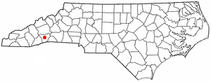
Balfour is an unincorporated community and census-designated place (CDP) in Henderson County, North Carolina, United States. The population was 1,187 at the 2010 census. It is part of the Asheville Metropolitan Statistical Area.

<span class="mw-page-title-main">Lowesville, North Carolina</span> Census-designated place in North Carolina, United States

Lowesville is a census-designated place (CDP) in Lincoln County, North Carolina, United States. The population was 2,945 at the 2010 census, up from 1,440 in 2000.

Keener is a census-designated place (CDP) in Sampson County, North Carolina, United States. The population was 508 at the 2000 census.

Plain View is a census-designated place (CDP) in Sampson County, North Carolina, United States. The population was 1,820 at the 2000 census.

Brogden is a census-designated place (CDP) in Wayne County, North Carolina, United States. The population was 2,510 in 2020. It is included in the Goldsboro, North Carolina Metropolitan Statistical Area.

Mar-Mac is a census-designated place (CDP) in Wayne County, North Carolina, United States. The population was 3,011 at the 2007 census. It is included in the Goldsboro, North Carolina Metropolitan Statistical Area.

<span class="mw-page-title-main">Eldon, Oklahoma</span> Census-designated place in Oklahoma, United States

Eldon is an unincorporated community and census-designated place (CDP) in Cherokee County, Oklahoma, United States. The population was 368 at the 2010 census, a loss of 62.3 percent from 991 at the 2000 census, due largely to shrinkage of the CDP boundaries. It lies east of Tahlequah at the junction of U.S. Highway 62 and State Highway 51. The Eldon Post Office existed from March 20, 1911, until May 30, 1936. The community is said to have been named for Eldon, Illinois.

<span class="mw-page-title-main">Cumberland Hill, Rhode Island</span> Census-designated place in Rhode Island, United States

Cumberland Hill is a census-designated place (CDP) in the town of Cumberland, in Providence County, Rhode Island, United States. The population was 7,934 at the 2010 census.

Fairfield Glade is a resort, retirement community and census-designated place (CDP) in Cumberland County, Tennessee, United States. The population was 9,152 at the 2020 census, up over 3,000 from the 2010 census.

<span class="mw-page-title-main">Carpendale, West Virginia</span> Town in West Virginia, United States

Carpendale is a town in Mineral County, West Virginia, United States, and part of the Cumberland, MD-WV Metropolitan Statistical Area'. The population was 861 at the 2020 census. Carpendale was incorporated on January 2, 1990, by the Circuit Court. The town is a combination of three subdivisions of which its name reflects: Carpenters Addition, Millerdale I, and Millerdale II. There are no stores in Carpendale and there is only one road in and out of the town.

<span class="mw-page-title-main">Wiley Ford, West Virginia</span> CDP in West Virginia, United States

Wiley Ford is a census-designated place (CDP) in Mineral County, West Virginia, United States and part of the 'Cumberland, MD-WV Metropolitan Statistical Area'. The population was 1,026 at the 2010 census.

<span class="mw-page-title-main">Falcon, North Carolina</span> Town in North Carolina, United States

Falcon is a town in Cumberland and Sampson counties in the U.S. state of North Carolina. The population was 258 at the 2010 census.

<span class="mw-page-title-main">Oak Hill, Maine</span> Census-designated place in Maine, United States

Oak Hill is a census-designated place (CDP) in the town of Scarborough in Cumberland County, Maine, United States. Prior to the 2020 census, the CDP was known as Scarborough. The population was 4,403 at the 2010 census. It is part of the Portland–South Portland–Biddeford, Maine Metropolitan Statistical Area.

References

  1. "ArcGIS REST Services Directory". United States Census Bureau. Retrieved September 20, 2022.
  2. 1 2 "U.S. Census website". United States Census Bureau . Retrieved 2008-01-31.
  3. "US Board on Geographic Names". United States Geological Survey. 2007-10-25. Retrieved 2008-01-31.
  4. 1 2 "Geographic Identifiers: 2010 Demographic Profile Data (G001): Vander CDP, North Carolina". U.S. Census Bureau, American Factfinder. Archived from the original on February 12, 2020. Retrieved January 6, 2015.
  5. "US Gazetteer files: 2010, 2000, and 1990". United States Census Bureau. 2011-02-12. Retrieved 2011-04-23.
  6. "Census of Population and Housing". Census.gov. Retrieved June 4, 2016.