Varkala

Last updated

Varkala
Udaya Marthandapuram [1]
Town
Varkala Beach, Varkala, Kerala.jpg
Varkala Beach
Nickname: 
Pearl of Arabian Sea [1] Goa of Kerala
India Kerala location map.svg
Red pog.svg
Varkala
India location map.svg
Red pog.svg
Varkala
Coordinates: 8°44′36″N76°41′49″E / 8.7432986°N 76.6968401°E / 8.7432986; 76.6968401
CountryIndia
State Kerala
District Thiruvananthapuram
Talukas Varkala Taluk
Government
  Type Municipality
  Body Varkala Municipality
   Chairman K.M.LAJI
Area
  Total14.87 km2 (5.74 sq mi)
  Rank3
Elevation
58 m (190 ft)
Population
 (2011) [2]
  Total40,048
  Rank3
  Density2,700/km2 (7,000/sq mi)
Demonym(s) Varkalakkaran, Varkalaite
Languages
  Official Malayalam, English
Time zone UTC+5:30 (IST)
PIN
695141
Telephone code0470
Vehicle registration KL-81
Nearest City Airport
Niyamasabha constituencyVarkala
Website www.varkalamunicipality.in

Varkala formerly known as Balita is a major coastal municipality situated in the northern suburb of Thiruvananthapuram, capital city of the Indian state Kerala.

Contents

In legends and myths related to Kerala, texts like the Kerala Mahatmyam describe the Varkala region as one of the sacred places of Kerala.

Varkala shares many cultural and linguistic similarities with the neighboring Kollam district or Central Travancore rather than the Trivandrum and Attingal region.

Varkala is situated to the 41 km north of Trivandrum city and 27 km south of Kollam city.

Varkala is the only region in southern Kerala where cliffs are found adjacent to the Arabian Sea. [3] These Cenozoic sedimentary formation cliffs are a unique geological feature on the otherwise flat Kerala coast, and are known among geologists as Varkala Formation. The cliffs have been declared a national geological monument by the Geological Survey of India for their protection, maintenance, promotion, and the enhancement of geotourism. There are numerous water spouts and spas on the sides of these cliffs. In 2015, the Ministry of Mines, the Government of India, and the Geological Survey of India (GSI) declared Varkala Cliffs a geo-heritage site. [4] [5]

Varkala is also known for the 2,000-year-old Janardana Swami Temple, which is an important Vaishnavaite shrine in India and is often referred to as Dakshin Kashi (Benares of the South). [6] The temple is located close to Papanasam beach, which is an Ayurveda treatment centre. The temple has an ancient bell removed from a shipwreck, donated by the captain of the Dutch vessel which sank near Varkala without causing any casualties.[ citation needed ]

Another major landmark in Varkala is the Sivagiri Mutt, established by the social reformer Sree Narayana Guru.[ citation needed ]

Etymology

History

Legends

It is believed that a Pandyan King was instructed by Lord Brahma to build a temple at this very place to redeem him of his sins. Several other myths abound on the birth of Varkala. Another legend states that when a group of pilgrims approached Sage Narada and told him that they had sinned, Narada threw his valkalam (a loin cloth made from the bark of a tree) and it landed at this scenic village and hence, the place came to be known as Varkala. Narada told the pilgrims to pray for their redemption at Papanasam, which literally means redemption from sins. [7]

Geography

Varkala is located at 8°44′36″N76°41′49″E / 8.7432986°N 76.6968401°E / 8.7432986; 76.6968401 . [8]

Religion

As per the Census 2011, the total Hindu population in Varkala municipality is 28,273 which is 70.6% of the total population. Also the total Muslim population in Varkala is 11,562 which is 28.87% of the total population.[ citation needed ]

Geology

Varkala is an important place as far as geology is concerned as it exposes sedimentary rocks belonging to the Cenozoic age, popularly known in the geological literature as the Warkalli formation. The Warkalli formation, along with the Quilon formation, represent sediments laid down in the Kerala basin that existed during Mio-pliocene times. The Quilon formation of the Miocene age is made up of limestone, and the Warkalli formation is made up of alternating beds of sand and shale exposed along the Varkala cliffs. Thin seams of lignite in the shale of the Warkalli formation suggest good vegetation at the time of deposition of the clay sediments.[ citation needed ]

Government and politics

Local government

Varkala is a municipality in the Thiruvananthapuram District. Urban civic administration is overseen by the Varkala municipality or municipal council, while the rural civic administration is under the charge of the 7 panchayats of Edava, Elakamon, Vettoor, Madavoor, Navaikulam, Pallickal, and Chemmaruthy in Varkala Taluk. [9]

The Varkala municipality has 33 wards [10] under it and also has 6 standing committees [11] that take care of basic amenities such as water, sewage, roads, taxes, and other such city or local government functions.

Elected representatives to the State Assembly and to the Indian Parliament

Varkala comes under the Attingal Lok Sabha Constituency. There are seven State Assembly Constituencies [12] within Attingal Lok Sabha Constituency, of which Varkala is one. One Member of the Legislative Assembly (MLA) is elected from Varkala with Legislative Assembly no. 127. [13]

Economy

Varkala is a well-known tourism and commercial destination. More than 300 resorts and hotels are situated in the municipality, including a Taj Hotel, owned by Tata Group. The city has an average-rated water supply system, fire station, automobile showrooms, several post offices, engineering and degree colleges and a police station. It also has government-run medical facilities in addition to over 10 private hospitals and clinics. A government-run naturopathic hospital is located near the Papanasam cliff. The District Ayurvedic Hospital is located in Varkala.[ citation needed ]

Varkala is an important hub for neighbouring places like Attingal, Kadakkavur, Chirayinkeezhu, Kallambalam, Paravur, and Kilimanoor.[ citation needed ]

Transport

Air

Trivandrum International Airport (39 km) is the nearest airport and is well connected with all major cities in India and Abroad and there is also a helipad at Varkala Cliff.

Rail

Varkala Railway Station, the second busiest and third highest revenue-generating station in Thiruvananthapuram district, is well connected by regular trains from to major metropolitan cities in India like Mumbai, Delhi, Bangalore, Pune, Chennai, Hyderabad, Goa, Kolkata,Vishakapatnam etc.

Road

Varkala is situated along the Trivandrum - Kollam coastal highway. It is also connected by the State Highway 64 with the Mumbai-Kanyakumari National Highway 66 which runs at 9 km towards the east. Private buses and KSRTC buses ply along NH 66 and through Varkala from Thiruvananthapuram city, Attingal, Parippally and Kollam city.

Water

Varkala is connected to National Waterway 3 through Varkala Tunnel, which passes through the heart of the city. [14]

Tourism

Varkala Promenade Varkala Promenade.jpg
Varkala Promenade

Tourism began to thrive at the end of the last century at Varkala beach (Papanasam), which was earlier famous for Vavu Beli, a Hindu custom performed at the beach. Another beach is at Tiruvambadi, one kilometre away and on the way to the old palace. An island called Ponnumthuruthu is close to Varkala and is also a tourist attraction.

Many ayurvedic massage parlours line the promenade above the beach.[ citation needed ]

Varkala Beach

Varkala Beach, or Papanasam Beach, offers opprotunities for sunbathing, swimming and water sports opportunities. Special authentic Kerala style local food can also be experienced along the cliff.[ citation needed ] The cliff and the beach include resorts, restaurants, and other shops.

The black part of the sand on Varkala Beach contains thorium oxide, which is a radioactive substance. Thorium and thorium oxide and its isotopes are found all over Kerala and can be identified by their black colour. [15]

Papanasam beach in Varkala seen from the cliffs above Papanasam beach, Varkala.jpg
Papanasam beach in Varkala seen from the cliffs above

Cremations

Sections of Varkala Beach (Papanasam Beach) are used by Indians to scatter the ashes of their cremated relatives into the sea. Despite this burial activity, the sea is popular with swimmers both local and foreign.[ citation needed ]

Kappil Lake

Edava-Nadayara Lake: A scene from Paravur Thekkumbhagam Edava Nadayara Lake.JPG
Edava-Nadayara Lake: A scene from Paravur Thekkumbhagam

Kappil Lake is about 4 kilometers (2.5 mi) north of Varkala Town. This serene estuary meanders through dense coconut groves before merging into the Arabian Sea. The bridge over the lake is a vantage point to view the backwater stretching white and grey to the distant blue horizon. Boating is another way to browse this waterway.[ citation needed ]

Anjengo Fort

Anjengo Fort is a fort near Varkala. The historic significance tagged to Anjengo comes through foreign powers like the Portuguese, the Dutch, and finally the English East India Company. In the year 1684, the English East India Company chose Anjengo to establish their first trade settlement in Kerala. At Anjengo, one can find the remnants of the old English Fort, which was targeted several times by other foreign powers, who were at that time fighting each other to get a firm footing in Kerala. The fort is now under the protection of National Heritage Monuments. There is also a cemetery inside the fort and the oldest burial site dates to 1704. Muthalapuzhi Lake is situated in Anjengo.[ citation needed ]

Varkala Tunnel

Varkala Tunnel Varkala Tunnel.jpg
Varkala Tunnel

Varkala Tunnel is an old tourist highlight. Its construction began in 1867 under the supervision of Travancore Diwan Sir. T Mahadeva Rao and was completed only in 1880, at the time of Diwan Sheshaya Sasthri. [16] Varkala Lighthouse is another tourist highlight in the vicinity.[ citation needed ]

Religious centres

Janardana Swami Temple

Janardhana Swami Temple Pond 45229-001.jpg
Janardhana Swami Temple Pond
Sivagiri Mutt Sivagiri (1).jpg
Sivagiri Mutt

Janardana Swami Temple is a very important Vaishnavite shrine and attracts thousands of pilgrims. The temple is about 2,000 years old. Facing the temple is Papasnanam Beach, where devotees take a bath in the belief that the sacred waters will wash away their sins. A large bell washed up from the wreck of a Dutch merchant vessel is kept on display at the temple.[ citation needed ]

Sivagiri Mutt

Sivagiri Mutt is a famous ashram in Varkala, founded by the philosopher and social reformer Sree Narayana Guru. Sree Narayana Guru's tomb is also located here. The samadhi (the final resting place) of the Guru attracts thousands of devotees every year during the Sivagiri pilgrimage, from December 30 to January 1. The Sivagiri Mutt, built in 1904, is situated at the top of the Sivagiri hill in Varkala. The Sivagiri Mutt is also the headquarters of the Sree Narayana Dharma Sangham, an organization of his disciples and saints, established by the Guru to propagate his concept of 'One Caste, One Religion, One God'. The Guru Deva Jayanti, the birthday of the Guru, and the samadhi day, are celebrated in August and September respectively every year. Colourful processions, debates and seminars, public meetings, cultural shows, community feasts, group weddings, and rituals mark the celebrations.[ citation needed ]

Panayara Triporittakkavu Bhagavathi Temple

Panayara Triporittakkavu Bhagavathi Temple is one of the most famous Devi temples in Kerala. Meenabharani festival is the primary festival in Porittakkavu temple, celebrating the month of 'Meenam' (March/April) in the Malayalam calendar.[ citation needed ]

Sarkara Devi Temple

Sarkara Devi Temple is an old temple situated near Varkala at Chirayinkeezhu. The temple is famous for the Kaliyoot festival on the Malayalam month of Kumbham (March).[ citation needed ]

Sree Saraswathy Temple

The Sree Saraswathy Temple, located in Venkulam, Edava, is a VidyaDevi temple known for Navarathri Sangeetholsavam and Vijayadesami Vidyarambam.[ citation needed ]

Kaduvayil Juma Masjid

Kaduvayil Juma mosque, situated on NH47, between Kallambalam and Attingal, is a Sunni pilgrimage centre which attracts local Muslims.


Mambazhamoola Mahaganapathi temple

Mambazhamoola Mahaganapathi Kshethram is a renowned Hindu temple dedicated to Lord Ganesha located in Varkala-Ayroor, Kerala, India. Believed to be one of the oldest Ganesha temples in the region, it holds a special place in the hearts of devotees who flock to seek blessings and solace from the elephant-headed deity.

Climate

The Köppen-Geiger climate classification system classifies Varkala's climate as tropical monsoon. It has heavy rains during June–August due to a southwest monsoon. In summer, the temperature rises to a maximum of 32 °C (90 °F) and 31 °C (88 °F) in the winters. The highest temperature recorded in neighbouring Thiruvananthapuram is 39 °C (102 °F). Annual average rainfall is 3,100 mm (120 in).[ citation needed ]

Climate data for Varkala
MonthJanFebMarAprMayJunJulAugSepOctNovDecYear
Mean daily maximum °C (°F)29.9
(85.8)
30.7
(87.3)
31.7
(89.1)
31.8
(89.2)
31.3
(88.3)
29.1
(84.4)
28.6
(83.5)
28.9
(84.0)
29.3
(84.7)
29.3
(84.7)
29.1
(84.4)
29.3
(84.7)
29.9
(85.8)
Daily mean °C (°F)26.1
(79.0)
26.9
(80.4)
28.1
(82.6)
28.6
(83.5)
28.2
(82.8)
26.5
(79.7)
25.9
(78.6)
26.2
(79.2)
26.5
(79.7)
26.5
(79.7)
26.2
(79.2)
26
(79)
26.8
(80.3)
Mean daily minimum °C (°F)22.4
(72.3)
23.2
(73.8)
24.5
(76.1)
25.4
(77.7)
25.2
(77.4)
23.9
(75.0)
23.3
(73.9)
23.5
(74.3)
23.7
(74.7)
23.7
(74.7)
23.4
(74.1)
22.7
(72.9)
23.7
(74.7)
Average precipitation mm (inches)19
(0.7)
27
(1.1)
52
(2.0)
144
(5.7)
248
(9.8)
457
(18.0)
336
(13.2)
222
(8.7)
201
(7.9)
290
(11.4)
205
(8.1)
55
(2.2)
2,256
(88.8)
Average rainy days123810191714111283108
Mean daily sunshine hours 9988755666677
Source 1: Climate-Data.org [17]
Source 2: Weather2Travel [18] for sunshine and rainy days

See also

Related Research Articles

<span class="mw-page-title-main">Narayana Guru</span> Indian spiritual leader and social reformer (1856–1928)

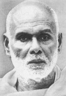
Sree Narayana Guru was a philosopher, spiritual leader and social reformer in India. He led a reform movement against the injustice in the caste-ridden society of Kerala in order to promote spiritual enlightenment and social equality. A quote of his that has become popular: "one caste, one religion, and one god for all human beings". He is the author of the Advaita poem Daiva Dasakam, which is one of the most used poem in Kerala for community prayer.

<span class="mw-page-title-main">Attingal</span> Town in Kerala, India

Attingal is a municipality in Thiruvananthapuram metropolitan area in Thiruvananthapuram district of Kerala state, India. It was the location of the Attingal kingdom, under Travancore. It is the headquarters of Chirayinkeezhu Taluk, and the important government institutions of the taluk such as the Taluk office, court complex, office of the deputy superintendent of Police, civil station, and treasuries are situated in Attingal. It is one of the oldest municipalities of Kerala which was constituted prior to its independence in 1924. In 1914 itself Attingal Town Improvement Authority (TIA) was formed which was the term used before the municipality regulation act of 1922. Attingal Town is located 25 kilometres (16 mi) north of Thiruvananthapuram. Attingal is the 3rd densely populated municipality in the district.

<span class="mw-page-title-main">Nedumangad</span> Municipality in Kerala, India

Nedumangad is a municipal town in the Thiruvananthapuram district in the Indian state of Kerala. It is the headquarters of Nedumangad Tehsil and Nedumangad Revenue Division. It is a suburb of the extended metropolitan region of Thiruvananthapuram. It is located around 16 km (9.9 mi) to the north-east of Thiruvananthapuram on the State Highway 2. It is an important commercial center in the district. It is a growing commercial and educational hub and all important government institutions are situated in the town. The Nedumangadu market has significance in southern Kerala.

Paravur is a municipality in the Kollam district of Kerala, India. Paravur is located 11.6 km (7.2 mi) southeast of the Kollam city centre, and is a part of the Kollam metropolitan area. Paravur railway station is the last station in Kollam district which is on the route to Trivandrum while travelling towards South India.

<span class="mw-page-title-main">Thiruvananthapuram district</span> District in Kerala, India

Thiruvananthapuram District is the southernmost district in the Indian state of Kerala. The district was created in 1949, with its headquarters in the city of Thiruvananthapuram, which is also Kerala's administrative centre. The present district was created in 1956 by separating the four southernmost Taluks of the erstwhile district to form Kanyakumari district. The city of Thiruvananthapuram is also known as the Information technology capital of the State, since it is home to the first and largest IT park in India, Technopark, established in 1990. The district is home to more than 9% of total population of the state.

<span class="mw-page-title-main">Parippally</span> Town in Kerala, India

Parippally is a town in kalluvathukkal panchayat Kollam, Kerala, India. Parippally is 22 kilometres (14 mi) South of Kollam City along NH66 and 44 kilometres (27 mi) North of Thiruvananthapuram along NH66. Kollam Govt. Medical College is situated in Parippally. Varkala sivagiri is nearest major Railway station 12 km(7.5 mi).

<span class="mw-page-title-main">Sivagiri, Kerala</span> Place

Sivagiri is an area in Varkala Municipality of Thiruvananthapuram district in Kerala. It is a pilgrimage centre of Varkala Town where the tomb, or samadhi, of Sree Narayana Guru is situated. It is a place where Guru built the Sarada Temple dedicated to Sarada Devi. The tomb is an attraction for thousands of devotees every year, especially during the Sivagiri Pilgrimage days from 30 December to 1 January.

<span class="mw-page-title-main">Temples consecrated by Narayana Guru</span>

Narayana Guru built temples at various locations in India: Kollam, Thiruvananthapuram, Thrissur, Kannur, Anchuthengu, Thalassery, Kozhikode, Mangalore. Some of the temples built by the guru are:

<span class="mw-page-title-main">G. Balakrishnan Nair</span>

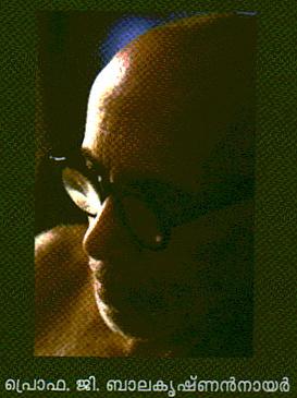
G. Balakrishnan Nair (1929–2011) was an Indian academic, author and Sanskrit scholar. He worked extensively on the philosophical works of Narayana Guru.

<span class="mw-page-title-main">Edava</span> Village in Kerala, India

Edava is a panchayat in Varkala Taluk, which is the northernmost tip of Trivandrum district in the state of Kerala, India. Edava is located 5km north of Varkala, 21km south of port city Kollam and 44km north of capital city Trivandrum. Kappil beach is a famous surf location.Surfsupkerala life saving club operates here.

<span class="mw-page-title-main">Chirayinkeezhu</span> Taluk in Kerala, India

Chirayinkeezhu is a town in Thiruvananthapuram district in the Indian state of Kerala. It was also hometown of famous Malayalam Film actor Prem Nazir. It is the seat of Chirayinkeezhu taluk.

Kappil is a seashore tourist spot located in Thiruvananthapuram district, Kerala, India. Varkala railway station is the major railway station near Kappil.

Kallambalam is a suburb of Varkala Town situated in Thiruvananthapuram district. Kallambalam joins Varkala with National Highway 66. It is 36 km north from state capital Trivandrum, 8 km East of Varkala and 12 km West of Kilimanoor.

<span class="mw-page-title-main">Anchuthengu</span> Historic site in Trivandrum, India

Anchuthengu, formerly known as Anjengo, Angengo or Anjenga, is a coastal panchayath and town in the Thiruvananthapuram District of Kerala. It is situated 9km south-west of Varkala Town along Trivandrum - Varkala - Kollam coastal highway.

Ponganadu is a village in the Thiruvananthapuram district, situated in the Indian state of Kerala. Madavoor (5 km), Nagaroor (6 km), Karavaram (7 km), Pulimath (7 km), Navaikulam (7 km) are other villages near Ponganadu. Ponganadu is surrounded by Chadayamangalam Taluk to the north, Varkala Taluk to the west, Vamanapuram Taluk to the east and Chirayinkeezhu Taluk to the south.

<span class="mw-page-title-main">Avanavanchery Sri Indilayappan Temple</span> Hindu temple in Kerala, India

Avanavanchery Sri Indilayappan Temple is a popular Hindu temple in Attingal of Thiruvananthapuram district, Kerala. The temple is dedicated to Lord Indilayappan and is one of the oldest temples in the state of Kerala. Lord Indilayappan is worshipped by devotees for getting good health, courage and better life prospects.

<span class="mw-page-title-main">Varkala Beach</span> Beach in Trivandrum, Kerala, India

Varkala Beach, also known as Papanasham Beach, is situated in the town of Varkala in Varkala Municipality, Thiruvananthapuram district, Kerala, India. The beach skirts the Arabian Sea, part of the Indian Ocean.

Varkala Sivagiri railway station is an NSG–4 category Indian railway station in Thiruvananthapuram railway division of Southern Railway zone. is a major railway station in Kerala serving the town of Varkala in Thiruvananthapuram. It is the second-busiest railway station in the state capital district Trivandrum in terms of passenger movement and 14th busiest in Kerala State. Around 54 trains halts in this station which handled more than 17,730 passengers daily with 3 platforms. It is on Kollam–Thiruvananthapuram trunk line. Station is well connected to major metropolitan & tier 2 cities like Trivandrum, Hyderabad, Kochi, Delhi, Bangalore, Mangalore, Chennai, Mumbai, Vijayawada, Kolkata, Goa etc.

<span class="mw-page-title-main">Geography of Thiruvananthapuram</span>

The Indian city of Thiruvananthapuram is located in Thiruvananthapuram district in the state of Kerala. The city is located at 8.5°N 76.9°E on the west coast, near the southern tip of mainland India. The city situated on the west coast of India, and is bounded by Arabian Sea to its west and the Western Ghats to its east. The city and the suburbs spans an area of 250 km2 (96.53 sq mi). The average elevation of the city is 16 ft above sea level. The highest point within the city limits is the observatory. Agastya Mala, which has an elevation of 1,868 metres (6,129 ft) is only about 60 km from the city. The Ponmudi hill station which has an elevation of 1,100 metres (3,609 ft) is also near the city.

<span class="mw-page-title-main">Varkala Tunnel</span> Water Tunnel System in Trivandrum, India

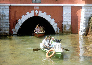
The Varkala Tunnel System, also known as the Varkala Canal or Varkala Thurapp in local dialect, is a system of tunnels situated in the municipality of Varkala of Trivandrum, Kerala, India. It is one of the region's most important historic sites and architectural marvels. This site was constructed by the Travancore Kingdom to establish a continuous inland waterway across Thiruvithamkoor as TS Canal, which was meant to serve as a trade route. The construction of the two long tunnels was started in 1867 and work on the first was finished in 1877, while the second was completed in 1880.

References

  1. 1 2 "Varkala History, Thiruvananthapuram, kerala, india, History of Varkala". www.varkkala.com.
  2. "Census of India: Search Details".
  3. http://www.varkala.info Archived 7 November 2018 at the Wayback Machine | Details of Varkala
  4. "Declaration of Geo-Heritage Sites". Press Information Bureau. 11 March 2015. Archived from the original on 1 February 2016. Retrieved 28 January 2016.
  5. Mahadevan, G. (7 July 2012). "Varkala cliff to be nation's first geopark". The Hindu. ISSN   0971-751X . Retrieved 28 January 2016.
  6. "Varkala". Kerala Tourism. Archived from the original on 19 July 2012. Retrieved 21 June 2012.
  7. "Varkala Beach". Kerala Tourism. Retrieved 20 November 2014.
  8. "Maps, Weather, and Airports for Varkkallai, India". www.fallingrain.com. Archived from the original on 5 February 2018. Retrieved 1 March 2010.
  9. "CEO Kerala Govt".
  10. "Ward map".
  11. "Varkala Municipality Standing Committees".
  12. "7 Assembly Constituencies for LDF in Attingal".
  13. "Maps of India".
  14. "Kerala PWD - State Highways". Kerala State Public Works Department. Archived from the original on 1 December 2010. Retrieved 26 February 2010.
  15. "Kerala". Explorra.com. Retrieved 20 October 2013.
  16. "Varkala tunnel, Thiruvananthapuram, Kerala, India". Kerala Tourism - Varkala. Retrieved 22 February 2021.
  17. "Climate: Varkala - Climate graph, Temperature graph, Climate table". Climate-Data.org. Retrieved 27 August 2013.
  18. "Varkala Climate and Weather Averages, Kerala". Weather2Travel. Retrieved 27 August 2013.