Vassar, Michigan

Last updated
Vassar, Michigan
Nickname(s): 
Cork Pine City, V-Town
Tuscola County Michigan Incorporated and Unincorporated areas Vassar Highlighted.svg
Location of Vassar, Michigan
Coordinates: 43°22′19″N83°34′53″W / 43.37194°N 83.58139°W / 43.37194; -83.58139
Country United States
State Michigan
County Tuscola
Founded1 March 1849
Area
[1]
  Total2.20 sq mi (5.69 km2)
  Land2.15 sq mi (5.56 km2)
  Water0.05 sq mi (0.12 km2)
Elevation
643 ft (196 m)
Population
 (2020)
  Total2,727
  Density1,269.55/sq mi (490.07/km2)
Time zone UTC-5 (Eastern (EST))
  Summer (DST) UTC-4 (EDT)
ZIP codes
48768-48769
Area code 989
FIPS code 26-81840 [2]
GNIS feature ID1615523 [3]
Website www.cityofvassar.org

Vassar is a city in Tuscola County in the U.S. state of Michigan. Founded March 1, 1849. The population was 2,727 at the 2020 census and 2,697 in 2010 (an increase of about 1.1%). The city is located on the western edge of Vassar Township but is administratively autonomous.

Contents

History

Vassar was founded by four men who were led by James M. Edmunds and Townsend North in search of an area to build a dam and start a city. The city was named after Edmund's uncle, Matthew Vassar, who later founded Vassar College.

It was the first county seat of Tuscola County. In 1860, the seat was moved to Caro. Vassar's growth for the next thirty years was based mainly on its lumbering and a handful of related industries. [4]

The settlement became a village in 1871. Vassar was the crossing of the Michigan Central's Bay City Branch (from Detroit) and the Port Huron & Northwestern (from 1900 Pere Marquette) line running between Saginaw and Port Huron via Marlette. [5]

The voters of the Village of Vassar elected to become a city on September 28, 1944. On February 19, 1945, the voters approved the charter for the City of Vassar. [6]

Geography

Demographics

Historical population
CensusPop.Note
1880 670
1890 1,682151.0%
1900 1,8328.9%
1910 1,659−9.4%
1920 1,453−12.4%
1930 1,81625.0%
1940 2,15418.6%
1950 2,53017.5%
1960 2,6805.9%
1970 2,8024.6%
1980 2,727−2.7%
1990 2,559−6.2%
2000 2,82310.3%
2010 2,697−4.5%
2020 2,7271.1%
U.S. Decennial Census [8]

2010 census

As of the census [9] of 2010, there were 2,697 people, 1,001 households, and 668 families living in the city. The population density was 1,272.2 inhabitants per square mile (491.2/km2). There were 1,154 housing units at an average density of 544.3 per square mile (210.2/km2). The racial makeup of the city was 87.4% White, 8.8% African American, 0.4% Native American, 0.1% Asian, 1.1% from other races, and 2.2% from two or more races. Hispanic or Latino of any race were 3.0% of the population.

There were 1,001 households, of which 35.3% had children under the age of 18 living with them, 45.4% were married couples living together, 16.2% had a female householder with no husband present, 5.2% had a male householder with no wife present, and 33.3% were non-families. 28.2% of all households were made up of individuals, and 11.2% had someone living alone who was 65 years of age or older. The average household size was 2.47 and the average family size was 2.99.

The median age in the city was 32.5 years. 31.6% of residents were under the age of 18; 9% were between the ages of 18 and 24; 23% were from 25 to 44; 24.5% were from 45 to 64; and 11.8% were 65 years of age or older. The gender makeup of the city was 49.8% male and 50.2% female.

2000 census

As of the census [2] of 2000, there were 2,823 people, 991 households, and 676 families living in the city. The population density was 1,266.2 inhabitants per square mile (488.9/km2). There were 1,062 housing units at an average density of 476.3 per square mile (183.9/km2). The racial makeup of the city was 88.42% White, 8.25% African American, 0.21% Native American, 0.21% Asian, 1.35% from other races, and 1.56% from two or more races. Hispanic or Latino of any race were 2.94% of the population.

There were 991 households, out of which 34.0% had children under the age of 18 living with them, 51.2% were married couples living together, 12.9% had a female householder with no husband present, and 31.7% were non-families. 28.8% of all households were made up of individuals, and 12.6% had someone living alone who was 65 years of age or older. The average household size was 2.55 and the average family size was 3.14.

In the city, the population was spread out, with 34.2% under the age of 18, 8.9% from 18 to 24, 26.4% from 25 to 44, 18.6% from 45 to 64, and 11.9% who were 65 years of age or older. The median age was 30 years. For every 100 females, there were 106.5 males. For every 100 females age 18 and over, there were 83.9 males.

The median income for a household in the city was $38,087, and the median income for a family was $44,924. Males had a median income of $32,045 versus $22,305 for females. The per capita income for the city was $15,029. About 6.3% of families and 9.2% of the population were below the poverty line, including 11.8% of those under age 18 and 7.0% of those age 65 or over.

Education

Vassar Public Schools: [10]

St. Luke's Lutheran School is a grade school of the Wisconsin Evangelical Lutheran Synod in Vassar. [11]

Related Research Articles

<span class="mw-page-title-main">Tuscola, Illinois</span> City in Illinois, United States

Tuscola is a city in Douglas County, Illinois, United States. The population was 4,636 at the 2020 census. It is the county seat of Douglas County.

<span class="mw-page-title-main">Lowell, Indiana</span> Town in Indiana, United States

Lowell is a town in West Creek and Cedar Creek townships, Lake County, Indiana, United States. The population was 10,680 at the 2020 census.

<span class="mw-page-title-main">Willey, Iowa</span> City in Iowa, United States

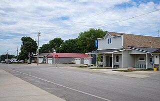
Willey is a city in Carroll County, Iowa, United States. The population was 73 at the time of the 2020 census.

<span class="mw-page-title-main">Cumberland, Maine</span> Town in Maine, United States

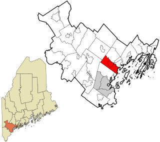
Cumberland is a town in Cumberland County, Maine, United States. The population was 8,473 at the time of the 2020 census. It is part of the Portland metropolitan area, Maine. Cumberland is one of the wealthiest municipalities in the state.

Rich Township is a civil township of Lapeer County in the U.S. state of Michigan. The population was 1,623 at the 2010 Census.

<span class="mw-page-title-main">Corunna, Michigan</span> City in Michigan, United States

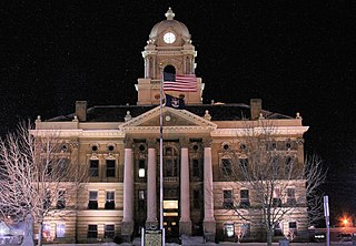
Corunna ( CORE-UN-NUH) is a city and county seat of Shiawassee County in the U.S. state of Michigan. The population was 3,497 at the 2010 census. The city is surrounded by Caledonia Charter Township and is slightly east of the city of Owosso.

<span class="mw-page-title-main">Akron Township, Michigan</span> Township in Michigan, United States

Akron Township is a civil township of Tuscola County in the U.S. state of Michigan. The population was 1,379 at the 2020 Census.

Almer Charter Township is a charter township of Tuscola County in the U.S. state of Michigan. The population was 1,965 at the 2020 census. It is the only charter township in the Upper Thumb region of Michigan.

<span class="mw-page-title-main">Caro, Michigan</span> City in Michigan, United States

Caro is a city in and the county seat of Tuscola County, Michigan, United States. The population was 4,328 at the 2020 census and 4,145 at the 2000 census.

Denmark Township is a civil township of Tuscola County in the U.S. state of Michigan. The population was 3,068 at the 2010 Census.

Fairgrove Township is a civil township of Tuscola County in the U.S. state of Michigan. The population was 1,579 at the 2010 Census. The village of Fairgrove is located within the township, as well as the southern half of the village of Akron.

Fremont Township is a civil township of Tuscola County in the U.S. state of Michigan. The population was 3,312 at the 2010 Census.

<span class="mw-page-title-main">Gagetown, Michigan</span> Village in Michigan, United States

Gagetown is a village in Tuscola County in the U.S. state of Michigan. The population was 388 at the 2010 census. It is located in the northeastern corner of Elmwood Township.

Millington Township is a civil township of Tuscola County in the U.S. state of Michigan. The population was 4,354 as of the 2010 Census. The Village of Millington is located within the township.

Tuscola Township is a civil township of Tuscola County in the U.S. state of Michigan. The population was 2,082 at the 2010 Census.

Vassar Township is a civil township of Tuscola County in the U.S. state of Michigan. The population was 4,093 at the 2010 Census. The city of Vassar is located on the western edge of the township, but is administratively autonomous.

<span class="mw-page-title-main">Tuscola, Texas</span> City in Texas, United States

Tuscola is a city in Taylor County, Texas, United States. The population was 742 at the 2010 census. It is part of the Abilene, Texas Metropolitan Statistical Area.

<span class="mw-page-title-main">Memphis, Michigan</span> City in Michigan, United States

Memphis is a city that straddles the border between Macomb and St. Clair counties in the U.S. state of Michigan. The population was 1,084 at the 2020 census.

<span class="mw-page-title-main">Rib Mountain, Wisconsin</span> Village in Wisconsin, United States

Rib Mountain is a village located in Marathon County, Wisconsin, United States. The population was 7,313 at the 2020 census. A suburb of Wausau, it is part of the Wausau Metropolitan Statistical Area. The census-designated place of Rib Mountain is located in the village.

<span class="mw-page-title-main">Tuscola Township, Douglas County, Illinois</span> Township in Illinois, United States

Tuscola Township is one of nine townships in Douglas County, Illinois, USA. As of the 2020 census, its population was 5,460 and it contained 2,563 housing units.

References

  1. "2020 U.S. Gazetteer Files". United States Census Bureau. Retrieved May 21, 2022.
  2. 1 2 "U.S. Census website". United States Census Bureau . Retrieved 2008-01-31.
  3. "US Board on Geographic Names". United States Geological Survey. 2007-10-25. Retrieved 2008-01-31.
  4. "MICHMARKERS.COM". www.michmarkers.com.
  5. Michigan Railroads – Tuscola County – Vassar. Accessed April 2021.
  6. City of Vassar: First Charter. Accessed April 2021.
  7. "US Gazetteer files 2010". United States Census Bureau. Archived from the original on 2012-07-02. Retrieved 2012-11-25.
  8. "Census of Population and Housing". Census.gov. Retrieved June 4, 2015.
  9. "U.S. Census website". United States Census Bureau . Retrieved 2012-11-25.
  10. "Vassar Public Schools / District Homepage". www.vassar.k12.mi.us.[ permanent dead link ]
  11. "The School" . Retrieved September 12, 2019.