Related Research Articles
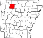
Newton County is a county in the U.S. state of Arkansas. As of the 2020 census, the population was 7,225. The county seat is Jasper. Newton County is Arkansas's 46th county, formed on December 14, 1842, and named for Thomas W. Newton, an Arkansas Congressman. It is an alcohol prohibition or dry county.
Logan County is a county located in the U.S. state of Arkansas. As of the 2020 census, the population was 21,131. Its two county seats are Booneville and Paris.

Johnson County is a county located in the U.S. state of Arkansas. As of the 2020 census, the population was 25,749. The county seat is Clarksville. Johnson County is Arkansas's 30th county, formed on November 16, 1833, from a portion of Pope County and named for Benjamin Johnson, a Territorial Judge. It is an alcohol prohibition or dry county.
Marble Falls is an unincorporated community in Newton County, Arkansas, United States. It lies along Arkansas's National Scenic 7 Byway between Harrison and Jasper. The Marble Falls Post Office is located in the parking lot of the now-defunct theme park called Dogpatch USA. For a time, the town was known as Dogpatch to promote the theme park.

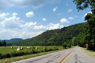
The Mulberry River is a 70-mile-long (110 km) tributary of the Arkansas River in northwestern Arkansas in the United States. Via the Arkansas River, it is part of the watershed of the Mississippi River. It has been designated a National Wild and Scenic River. The drainage basin of the Mulberry River has an area of 373 square miles (970 km2) and the annual average mean flow of the river near its mouth is 557 cubic feet per second.
Durham is an unincorporated community in eastern Washington County, Arkansas, United States. The community is on Arkansas Highway 16 along the White River valley between Elkins to the northwest and Thompson in Madison County to the southeast. Its elevation is 1,247 feet (380 m).

Gramling is a census-designated place located in Spartanburg County in the U.S. state of South Carolina. According to the 2010 United States Census, the population was 86.

North Arkansas College (Northark) is a public community college in Harrison, Arkansas. It serves the citizens of Boone, Carroll, Marion, Searcy, Newton, and Madison counties in northern Arkansas. Northark has two campuses in Harrison and one in Berryville, Arkansas.

Jackson Township is a township in Newton County, Arkansas, United States. Its total population was 1,620 as of the 2010 United States Census, an increase of 1.76 percent from 1,592 at the 2000 census.
Nail is an unincorporated community in Newton County, Arkansas, United States.
McAllister Springs is an unincorporated community in Saline County, in the U.S. state of Missouri.
Crooked Creek is a stream in Newton, Boone and Marion counties of north Arkansas. It is a tributary of the White River.
Boston is an unincorporated community in the Boston Mountains of southeastern Madison County, Arkansas, United States. The community is located on Arkansas Highway 16 between Pettigrew to the southwest and Red Star to the northeast. The community is on a high ridge at an elevation of 2,329 feet (710 m). The location is at the headwaters of four streams: Kings River to the northeast, War Eagle Creek to the northwest, the White River to the east and southwest and Little Mulberry Creek to the southeast.
Bowen Township is one of 21 inactive townships in Madison County, Arkansas, USA. As of the 2010 census, its population was 486.
Kentucky Township is one of 21 inactive townships in Madison County, Arkansas, USA. As of the 2010 census, its population was 265.
Valley Township is one of 21 inactive townships in Madison County, Arkansas, USA. As of the 2010 census, its population was 517.
White River Township is one of 21 inactive townships in Madison County, Arkansas, USA. As of the 2010 census, its population was 248.
Osage Creek is a stream in Newton, Boone, and Carroll counties of northern Arkansas. It is a tributary of the Kings River.
Hurricane Creek is a tributary to the Big Piney Creek, a river in Ozark-St. Francis National Forest in the state of Arkansas, which is a tributary of the Arkansas River and which is, in turn, part of the Mississippi River System. It is managed by the United States Forest Service and categorized as one of the Wild and Scenic Rivers of the United States.