Vernon Township, Hancock County, Indiana

Last updated

Vernon Township
Map highlighting Vernon Township, Hancock County, Indiana.svg
Location in Hancock County
Coordinates: 39°54′25″N85°52′17″W / 39.90694°N 85.87139°W / 39.90694; -85.87139
Country United States
State Indiana
County Hancock
Government
  Type Indiana township
Area
  Total31.33 sq mi (81.1 km2)
  Land31.26 sq mi (81.0 km2)
  Water0.07 sq mi (0.2 km2)  0.22%
Elevation
863 ft (263 m)
Population
 (2020)
  Total15,615
  Density352.1/sq mi (135.9/km2)
GNIS feature ID 0453955

Vernon Township is one of nine townships in Hancock County, Indiana, United States. As of the 2020 census, its population was 15,615 and it contained 4,322 housing units. [1]

Contents

History

Vernon Township was organized in 1836. [2] It was named after Mount Vernon, the plantation home of President George Washington. [3] Vernon Township which includes McCordsville, Fortville and the unincorporated portion of Vernon Township are reported to have a population of 15,615 according to the 2020 census.

Frank Littleton Round Barn was listed on the National Register of Historic Places in 1993. [4] This round barn was built in 1903. The Littleton Barn is a three-story round barn with an expansive hayloft and cupola. The barn is 102 feet in diameter making it the largest round barn in Indiana. The design is simple with vertically symmetrical windows on the first and second floor with a series of square windows along the roofline. The large domed roof leads to the large cupola that also features a number of windows. The Littleton Barn has become a regular feature on Indiana barn tours and remains one of the most well-known barns in the state.

[[Vernon Township Fire Department (VTFD) was founded in May 2019 with the opening of the new Vernon Township Fire Station 431 located at 600 Vitality Drive in Fortville. The McCordsville and Fortville Volunteer Fire Departments merged with the new Vernon Township Fire Department. The new EMS Department was started in January 2020. Previously EMS was outsourced to Seals/Priority Ambulance Service. The new Fire Department and Ambulance Service (EMS) became part of the Vernon Township Fire Protection Territory in June 2020. The Territory is made up of Vernon Township (Provider Unit), the Town of McCordsville (Participating Unit) and the Town of Fortville (Participating Unit). In December 2021 VTFD firefighters began 24/7 on station service operating from the McCordsville Volunteer Station on Form Street. A new full-service fire station was built near the corner of 600 and 900 in McCordsville and opened in August 2023. ]]

Geography

According to the 2020 census, the township has a total area of 31.33 square miles (81.1 km2), of which 31.26 square miles (81.0 km2) (or 99.78%) is land and 0.07 square miles (0.18 km2) (or 0.22%) is water. [1]

Towns

Parks

Unincorporated towns

(This list is based on USGS data and may include former settlements.)

Adjacent townships

Cemeteries

Vernon Township contains four historic cemeteries: 1. Gillium-Chappel Historic Cemetery on Railroad Street in McCordsville. The original Chapel was built circa 1854 and the cemetery was restored in 2022 2. McCordsville Historic Cemetery (aka IOOF Cemetery) on 600 South in McCordsville was built circa 1871 and restored in 2019 3. Cauldwell Historic Cemetery (aka Cauldwell-Brokaw) on W. State Rd 234 was built circa 1846 and restored in 2021 after a car accident did substantial damage to the small cemetery 4. Caudell-Simmons Historic Cemetery on CR 1050 N. in Fortville was built circa 1839 and is scheduled to be restored in the summer of 2022.

Major highways

Education

Vernon Township residents may obtain a free library card from the Vernon Township Public Library in Fortville. [5]

Vernon Township residents have an excellent public school system (A rating) with Mt. Vernon Community School Corporation which includes three Elementary Schools, a Middle School, and a High School. Headstart and pre-school are both offered. https://www.mvcsc.k12.in.us/

The Geist Montessori School, a tuition-free, a public charter school is located in McCordsville and offers Pre-K thru 8th-grade education. http://www.gmacademy.org/

Related Research Articles

<span class="mw-page-title-main">Hancock County, Indiana</span> County in Indiana, United States

Hancock County is a county in the U.S. state of Indiana. The 2020 United States Census recorded a population of 79,840. The county seat is Greenfield.

<span class="mw-page-title-main">Fortville, Indiana</span> Town in Indiana, United States

Fortville is a town in Vernon Township, Hancock County, Indiana, United States. The population was 4,784 at the 2020 census.

<span class="mw-page-title-main">Greenfield, Indiana</span> City in Indiana, United States

Greenfield is a city in and the county seat of Hancock County, Indiana, United States It lies in Center Township and is part of the Indianapolis metropolitan area. The population was 23,488 at the 2020 census.

<span class="mw-page-title-main">McCordsville, Indiana</span> Town in Indiana, United States

McCordsville is a town in Vernon Township, Hancock County, Indiana, United States. The town is a fast-growing suburb of Indianapolis with an estimated population of 8,592 in 2020.

<span class="mw-page-title-main">Mount Vernon, Indiana</span> City in Indiana, United States

Mount Vernon is a city in and the county seat of Posey County, Indiana, United States. Located in the state's far southwestern corner, within 15 miles (24 km) of both the southernmost or westernmost points, it is the westernmost city in the state. The southernmost is Rockport, located along the Ohio River about 40 miles (64 km) to the southeast.

<span class="mw-page-title-main">Lower Salford Township, Pennsylvania</span> Township in Pennsylvania, United States

Lower Salford is a township in Montgomery County, Pennsylvania. It is located one mile west of the Lansdale exit of the Pennsylvania Turnpike. It is centered on the intersection of Route 63, and Route 113.

<span class="mw-page-title-main">Charlottesville, Indiana</span> Unincorporated community and Census-designated place in Indiana, United States

Charlottesville is an unincorporated community in Hancock and Rush counties in the U.S. state of Indiana. The Hancock County portion is in Jackson Township, while the Rush County portion is in Ripley Township.

<span class="mw-page-title-main">Indiana's 6th congressional district</span> U.S. House district for Indiana

Indiana's 6th congressional district is a congressional district in the U.S. state of Indiana. The district takes in a portion of eastern and central Indiana as of the 2020 census, including Columbus and Richmond, some of Cincinnati's Indiana suburbs, most of Indianapolis' southern suburbs, and a sliver of Indianapolis itself.

<span class="mw-page-title-main">Blue River Township, Hancock County, Indiana</span> Township in Indiana, United States

Blue River Township is one of nine townships in Hancock County, Indiana, United States. As of the 2010 census, its population was 1,417 and it contained 542 housing units.

<span class="mw-page-title-main">Brandywine Township, Hancock County, Indiana</span> Township in Indiana, United States

Brandywine Township is one of nine townships in Hancock County, Indiana, United States. As of the 2010 census, its population was 2,392 and it contained 892 housing units.

<span class="mw-page-title-main">Brown Township, Hancock County, Indiana</span> Township in Indiana, United States

Brown Township is one of nine townships in Hancock County, Indiana, United States. As of the 2010 census, its population was 2,571 and it contained 1,067 housing units.

<span class="mw-page-title-main">Buck Creek Township, Hancock County, Indiana</span> Township in Indiana, United States

Buck Creek Township is one of nine townships in Hancock County, Indiana, United States. As of the 2010 census, its population was 8,430 and it contained 3,158 housing units.

<span class="mw-page-title-main">Center Township, Hancock County, Indiana</span> Township in Indiana, United States

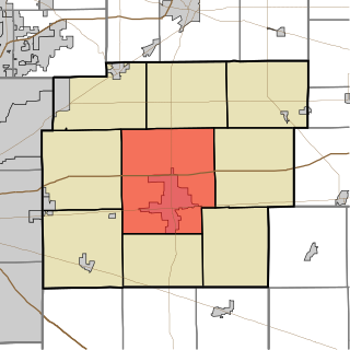
Center Township is one of nine townships in Hancock County, Indiana, United States. As of the 2010 census, its population was 25,819 and it contained 10,909 housing units.

<span class="mw-page-title-main">Green Township, Hancock County, Indiana</span> Township in Indiana, United States

Green Township is one of nine townships in Hancock County, Indiana, United States. As of the 2010 census, its population was 1,662 and it contained 663 housing units.

<span class="mw-page-title-main">Jackson Township, Hancock County, Indiana</span> Township in Indiana, United States

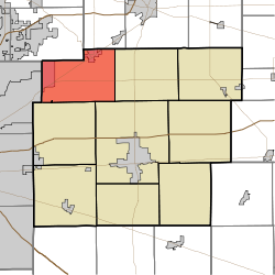
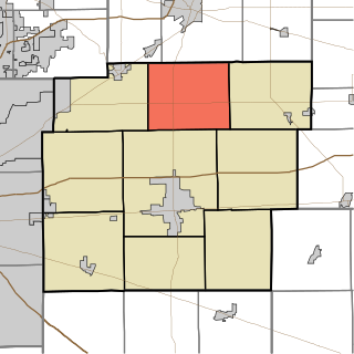
Jackson Township is one of nine townships in Hancock County, Indiana, United States. As of the 2010 census, its population was 1,786 and it contained 696 housing units.

<span class="mw-page-title-main">Sugar Creek Township, Hancock County, Indiana</span> Township in Indiana, United States

Sugar Creek Township is one of nine townships in Hancock County, Indiana, United States. As of the 2010 census, its population was 14,920 and it contained 5,876 housing units.

<span class="mw-page-title-main">Boone Township, Harrison County, Indiana</span> Place in Indiana, United States

Boone Township is one of 12 townships in Harrison County, Indiana, United States. As of the 2020 census, its population was 1,308 and it contained 593 housing units.

<span class="mw-page-title-main">Harrison Township, Henry County, Indiana</span> Township in Indiana, United States

Harrison Township is one of thirteen townships in Henry County, Indiana, United States. As of the 2010 census, its population was 1,352 and it contained 587 housing units.

Woodbury is an unincorporated community in Vernon Township, Hancock County, Indiana.

<span class="mw-page-title-main">Frank Littleton Round Barn</span> United States historic place

The Frank Littleton Round Barn, also known as the "Littleton-Pulliam Round Barn", is a round barn near Mount Comfort, Indiana, United States. Built in 1903, it was listed on the National Register of Historic Places in 1993.

References

  1. 1 2 "Population, Housing Units, Area, and Density: 2020 - County -- County Subdivision and Place -- 2020 Census Summary File 1". United States Census. Archived from the original on February 12, 2020. Retrieved May 10, 2013.
  2. Richman, George J. (1916). History of Hancock County, Indiana: Its People, Industries and Institutions. Wm. Mitchell Printing Company. pp.  783.
  3. Binford, John H. (1882). History of Hancock County, Indiana: From Its Earliest Settlement by the "pale Face," in 1818, Down to 1882. King & Binford. pp.  311.
  4. "National Register Information System". National Register of Historic Places . National Park Service. July 9, 2010.
  5. "Cards". Vernon Twp Public Library. Retrieved March 7, 2018.