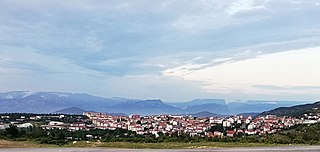
Söğüt is a town in Bilecik Province, Turkey. It is the seat of Söğüt District. Its population is 13,566 (2021).

Bilecik Province is a province in midwest Turkey, neighboring Bursa to the west, Kocaeli and Sakarya to the north, Bolu to the east, Eskişehir to the southeast and Kütahya to the south, spanning an area of 4,307 km2. The population is 228,334. Most of the province laid down in Marmara Region but eastern parts of Gölpazarı and Söğüt district and districts of İnhisar and Yenipazar remained in Black Sea Region, smaller southeastern parts of Bozüyük and Söğüt remained in Central Anatolia Region and smaller southwestern part of Bozüyük remained in Aegean Region.

Merzifon is a town in Amasya Province in the central Black Sea region of Turkey. It is the seat of Merzifon District. Its population is 61,376 (2021). The mayor is Alp Kargı (CHP).

Bilecik is a city in northwestern Anatolia, Turkey. It is the seat of Bilecik Province and Bilecik District. Its population is 74,457 (2021). The mayor is Melek Mızrak Subaşı (CHP).
Gölpazarı is a town in Bilecik Province in the Marmara region of Turkey. It is the seat of Gölpazarı District. Its population is 5,723 (2021). The mayor is Hayri Suer (AKP).

Osmaneli is a town in Bilecik Province in the Marmara region of Turkey. It is the seat of Osmaneli District. Its population is 16,192 (2021). The mayor is Münür Şahin. Its neighbours are Pamukova from north, Geyve from north-east, Gölpazarı from south-east, Bilecik from south, Yenişehir from south-west and İznik from west.
Bolayır is a village in the Gelibolu District of Çanakkale Province, situated on the Gallipoli Peninsula in the European part of Turkey. Its population is 1,053 (2021).
Karabiga (Karabuga) is a town (belde) in the Biga District, Çanakkale Province, Turkey. Its population is 2,962 (2021). It is located at the mouth of the Biga River, on a small east-facing bay, known as Karabiga Bay. Its ancient name was Priapus or Priapos.

Yenişehir is a district of Bursa province. It is 52 km far from the east of Bursa and Bursa city center. Bursa's international airport is within the borders of Yenişehir. For this reason, the airport is called 'Yenişehir Airport'.
Bayram Pasha was an Ottoman grand vizier from 1637 to 1638 and the Ottoman governor of Egypt from 1626 to 1628.
Beğendik is a town (belde) in the Keşan District, Edirne Province, Turkey. Its population is 3,206 (2022). It is 10 kilometres (6.2 mi) from Keşan and about 115 kilometres (71 mi) from Edirne. Meriç River and Greece border are about 20 kilometres (12 mi) west of the town.
Dodurga is a town (belde) and municipality in the Bozüyük District, Bilecik Province, Turkey. Its population is 2,000 (2021). It is 17 kilometres (11 mi) south west of Bozüyük. According to legend, the name of the town refers to one of the sons of Oghuz Khan, i.e., Ayhan. The settlement was declared a seat of the township in 1958.

Selime formerly known as Salamis is a town (belde) and municipality in the Güzelyurt District, Aksaray Province, Turkey. Its population is 1,796 (2021).
Çaltı is a village in the Söğüt District, Bilecik Province, Turkey. Its population is 1,074 (2021). It is a few kilometers south of Sakarya River. The distance to Söğüt is 10 kilometres (6.2 mi) and the distance to Bilecik is 38 kilometres (24 mi). The settlement was founded by Yörüks. The name of the town refers to a scrubby hill at the east of the town. The settlement was declared a town (belde) in 1972. At the 2013 reorganisation, it became a village again.
Küre is a village in the Söğüt District, Bilecik Province, Turkey. Its population is 953 (2021). Before the 2013 reorganisation, it was a town (belde). It is 12 kilometres (7.5 mi) north of Söğüt and 24 kilometres (15 mi) east of Bilecik. The town was founded in the 13th century. Later Turkmen tribe of Kayı also settled in the village. The second sultan Orhan commissioned a mosque in the town. Another building referring to the history of the town is a türbe ("tomb") which is thought to be of Dursun Fakih, brother in law of Osman I.
Bayırköy is a town (belde) and municipality in the Bilecik District, Bilecik Province, Turkey. Its population is 1,793 (2021). It is about 20 kilometres (12 mi) north of Bilecik. Bayırköy consists of the quarters Fatih, Gazi and Sarmaşık.
Çardak is a town (belde) in the Lapseki District, Çanakkale Province, Turkey. Its population is 3,705 (2021).
Cihangazi is a village in the Bozüyük District, Bilecik Province, Turkey. Its population is 279 (2021). Before the 2013 reorganisation, it was a town (belde). It is 30 kilometres (19 mi) south of Bozüyük. The name of the village probably refers to an undated tombstone of a certain war hero named Cihangazi. Cihangazi was a more populous town in the past and its population is decreasing because of migration to cities.
Hasanpaşa is a village in Tefenni District of Burdur Province, Turkey. Its population is 533 (2021). Before the 2013 reorganisation, it was a town (belde). The distance to Tefenni is 14 kilometres (8.7 mi) and to Burdur is 92 kilometres (57 mi).
Tarpak is a village in the İnhisar District, Bilecik Province, Turkey. Its population is 271 (2021). Before the 2013 reorganisation, it was a town (belde).

