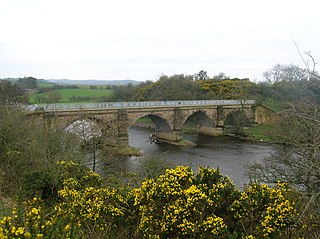
A viaduct is a specific type of bridge that consists of a series of arches, piers or columns supporting a long elevated railway or road. Typically a viaduct connects two points of roughly equal elevation, allowing direct overpass across a wide valley, road, river, or other low-lying terrain features and obstacles. The term viaduct is derived from the Latin via meaning "road", and ducere meaning "to lead". It is a 19th-century derivation from an analogy with ancient Roman aqueducts. Like the Roman aqueducts, many early viaducts comprised a series of arches of roughly equal length.
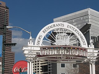
Underground Atlanta is a shopping and entertainment district in the Five Points neighborhood of downtown Atlanta, Georgia, United States, near the Five Points MARTA station. It is currently undergoing renovations. First opened in 1969, it takes advantage of the viaducts built over the city's many railroad tracks to accommodate later automobile traffic.

Harlem–125th Street station is a commuter rail stop serving the Metro-North Railroad's Hudson, Harlem, and New Haven Lines. It is located at East 125th Street and Park Avenue in East Harlem, Manhattan, New York City. The station also serves as an important transfer point between the Metro-North trains and the New York City Subway's IRT Lexington Avenue Line for access to the Upper East Side of Manhattan. It is the only station besides Grand Central Terminal that serves all three lines east of the Hudson River. Trains leave for Grand Central Terminal, as well as to the Bronx and the northern suburbs, regularly.

Riverside Drive is a scenic north–south avenue in the New York City borough of Manhattan. The road runs on the west side of Upper Manhattan, generally paralleling the Hudson River and Riverside Park between 72nd Street and the vicinity of the George Washington Bridge at 181st Street. North of 96th Street, Riverside Drive is a wide divided boulevard. At several locations, a serpentine service road diverges from the main road, providing access to the residential buildings. The avenue was opened in 1880, and several viaducts were completed over the subsequent decades to connect the various segments of Riverside Drive.

The Broadway Bridge is a Rall-type bascule bridge spanning the Willamette River in Portland, Oregon, United States, built in 1913. It was Portland's first bascule bridge, and it continues to hold the distinction of being the longest span of its bascule design type in the world. It was added to the National Register of Historic Places in November 2012.

The Maurice J. Tobin Memorial Bridge is a cantilever truss bridge that spans more than two miles (3.2 km) from Boston to Chelsea over the Mystic River in Massachusetts. The bridge is the largest in New England. It is operated by the Massachusetts Department of Transportation and carries U.S. Route 1. It was built between 1948 and 1950 and opened to traffic on February 2, 1950, replacing the former Chelsea Bridge. The 36-foot (11 m)-wide roadway has three lanes of traffic on each of the two levels with northbound traffic on the lower level and southbound traffic on the upper level.
From its incorporation in 1847, the municipal boundaries of Atlanta, Georgia, United States, were extended repeatedly from a small area around its railroad station to today's city covering 131.7 square miles (341 km2).
The Macombs Dam Bridge is a swing bridge across the Harlem River in New York City, connecting the boroughs of Manhattan and the Bronx. The bridge is operated and maintained by the New York City Department of Transportation (NYCDOT).

Downtown Atlanta is the central business district of Atlanta, Georgia, United States. The largest of the city's three commercial districts, it is the location of many corporate and regional headquarters; city, county, state, and federal government facilities; Georgia State University; sporting venues; and most of Atlanta's tourist attractions. It measures approximately four square miles, and had 26.850 residents as of 2017. Similar to other central business districts in the United States, it has recently undergone a transformation that includes the construction of new condos and lofts, renovation of historic buildings, and arrival of new residents and businesses.

The Harlem River Lift Bridge is a vertical lift bridge carrying the Metro-North Railroad's Hudson Line, Harlem Line, and New Haven Line across the Harlem River between the boroughs of Manhattan and the Bronx in New York City. The average weekday ridership on the lines is 265,000.

The Metropolitan Street Railroad was an early streetcar company in Atlanta.

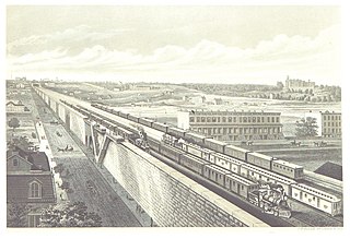
The Park Avenue main line, which consists of the Park Avenue Tunnel and the Park Avenue Viaduct, is a railroad line in the New York City borough of Manhattan, running entirely along Park Avenue. The line carries four tracks of the Metro-North Railroad as a tunnel from Grand Central Terminal at 42nd Street to a portal at 97th Street, where it rises to a viaduct north of 99th Street and continues over the Harlem River into the Bronx over the Park Avenue Bridge. During rush hours, Metro-North uses three of the four tracks in the peak direction.

The Park Avenue Viaduct, also known as the Pershing Square Viaduct, is a roadway in Manhattan, New York City. It carries vehicular traffic on Park Avenue from 40th to 46th Streets. The viaduct is composed of two sections: a steel viaduct with two roadways from 40th to 42nd Streets, as well as a pair of roadways between 42nd and 46th Streets. The section from 40th to 42nd Streets was designated a New York City landmark in 1980 and was listed on the National Register of Historic Places in 1983. The street-level service roads of Park Avenue, which flank the viaduct between 40th and 42nd Streets, are called Pershing Square. The section of the viaduct between 42nd and 46th Streets travels around Grand Central Terminal and the MetLife Building, then through the Helmsley Building; all three buildings lie across the north–south axis of the avenue.

Gray's Ferry Bridge has been the formal or informal name of several floating bridges and four permanent ones that have carried highway and rail traffic over the Schuylkill River in Philadelphia. The bridge today is a four-lane divided highway bridge, built in 1976, that carries Grays Ferry Avenue from the Grays Ferry neighborhood on the east bank, over the river and the Northeast Corridor railroad tracks, to the Southwest Philadelphia neighborhood of Kingsessing.
Marietta Street Artery is an officially defined neighborhood of the city of Atlanta, Georgia, part of the West Midtown area of Atlanta, also known as the "Westside."
The Peachtree Arcade was a shopping arcade in downtown Atlanta, Georgia, United States. The building, modeled after the Arcade in Cleveland, was designed by Atlanta-based architect A. Ten Eyck Brown and was located between Peachtree Street and Broad Street near Five Points. Construction began in 1917 and was completed the following year. Located in the city's central business district, it was very popular with citizens, functioning as an unofficial "civic center" for the city. However, by the 1960s, the arcade was facing increased competition from shopping malls located in Atlanta's suburbs, and in 1964, the building was demolished to make way for the First National Bank Building, a skyscraper that, at the time of its construction, was the tallest building in both Atlanta and the southeastern United States. In 1993, the American Institute of Architects named the building as one of Atlanta's most notable landmarks to have been destroyed.

Edgewood Avenue is a street in Atlanta, Georgia, United States which runs from Five Points in Downtown Atlanta, eastward through the Old Fourth Ward. The avenue runs in the direction of the Edgewood neighborhood, and stops just short of it in Inman Park. Edgewood Avenue was first important as the route of a streetcar line to Inman Park, Atlanta's first garden suburb and home to many of its most prominent citizens. Today, the avenue is known for its restaurants and nightlife around its intersection with Boulevard.
The 110th Street station was a station located on the Metro-North Railroad's Park Avenue Viaduct in East Harlem, Manhattan, New York City. The station was built by the New York Central & Hudson River Railroad as part of an agreement with the New York City government. It was located at Park Avenue and 110th Street.
The Bleckley Plaza Plan was a proposed engineering project in Atlanta, Georgia, United States. Proposed by architect Haralson Bleckley in the early 1900s, the project would have seen numerous railroads in downtown Atlanta covered by a large public plaza that would have run from the Georgia State Capitol to Terminal Station, covering much of The Gulch. The project, while considered at numerous points in the early 1900s, never came to fruition.


