Vilavila District

Last updated
Vilavila
Wila Wila
Country Flag of Peru.svg  Peru
Region Puno
Province Lampa
FoundedMay 2, 1854
Capital Vilavila
Government
   Mayor Justiniano Romulo Ahumada Viveros
Area
  Total156.65 km2 (60.48 sq mi)
Elevation
4,300 m (14,100 ft)
Population
  Total1,046
  Density6.7/km2 (17/sq mi)
Time zone UTC-5 (PET)
UBIGEO 210710

Vilavila (in Hispanicized spelling) or Wila Wila (Aymara wila red, blood-red, [1] the reduplication signifies that there is a group or a complex of something, "a complex of red color") is one of ten districts of the province Lampa in Peru. [2]

Contents

Geography

One of the highest peaks of the district is Pariwana at 5,022 m (16,476 ft). Other mountains are listed below: [3]

Ethnic groups

The people in the district are mainly indigenous citizens of Quechua descent. Quechua is the language which the majority of the population (98.12%) learnt to speak in childhood, while only 1.25% of the residents started speaking using the Spanish language (2007 Peru Census). [4]

Related Research Articles

<span class="mw-page-title-main">Lampa Province</span> Province in Puno, Peru

Lampa province is a province of the Puno Region in Peru. Its population is about 40,856. The capital is Lampa.

<span class="mw-page-title-main">General Sánchez Cerro Province</span> Province in Moquegua, Peru

The General Sánchez Cerro Province is the smallest of three provinces in the Moquegua Region of Peru. The capital of the province is Omate. The province was named after the former Peruvian army officer and president Luis Miguel Sánchez Cerro.

The Marcapata District is one of the twelve districts in the Quispicanchi Province in Peru. Created on January 20, 1869, its capital is Marcapata.

<span class="mw-page-title-main">Melgar Province</span> Province in Puno, Peru

Melgar Province is a province of the Puno Region in Peru. The capital of the province is the city of Ayaviri.

Corani is one of ten districts of the Carabaya Province in Peru.

Kelluyo is one of seven districts of the Chucuito Province in Peru.

<span class="mw-page-title-main">Mañazo District</span> District in Puno, Peru

Mañazo is one of fifteen districts of the province Puno in Peru.

Pichacani or Pichaqani is one of fifteen districts of the Puno Province in the Puno Region in Peru.

San Antonio District or San Antonio de Esquilache District is one of fifteen districts of the Puno Province in the Puno Region of Peru.

Tiquillaca District is one of fifteen districts of the province Puno in Peru.

Huatasani District is one of eight districts of the province Huancané in Peru.

<span class="mw-page-title-main">Cabanilla District</span> District in Puno, Peru

Cabanilla District is one of ten districts of the province Lampa in Peru.

Calapuja District is one of ten districts of the province Lampa in Peru.

<span class="mw-page-title-main">Lampa District, Lampa</span> District in Puno, Peru

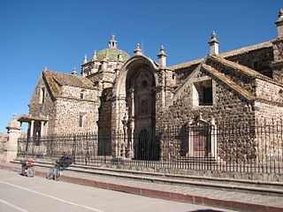
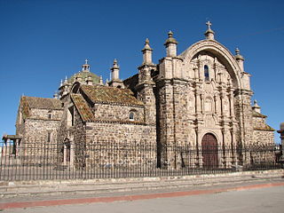
Lampa District is one of ten districts of the province Lampa in Peru.

<span class="mw-page-title-main">Nicasio District</span> District in Puno, Peru

Nicasio District is one of ten districts of the province Lampa in Peru.

Palca District is one of ten districts of the province Lampa in Peru.

Paratía District is one of ten districts of the province Lampa in Peru.

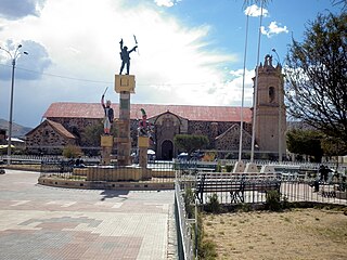
Pucará District is one of ten districts of the province Lampa in Peru.

<span class="mw-page-title-main">Santa Lucía District, Lampa</span> District in Puno, Peru

Santa Lucía District is one of ten districts of the province Lampa in Peru.

<span class="mw-page-title-main">Nuñoa District</span> District in Puno, Peru

Nuñuwa District is one of nine districts of the Melgar Province in Peru. The town of Nuñoa has become a destination for tourists as they start the climb to Machu Picchu. The growth of this local tourist industry has been stimulating changes in society, as the anthropologist Morgan Hoke has shown in a study of the impact of tourist eateries, especially pizzerias, on dairy and cheese production and on consequently on women's participation in the Nuñoa economy.

References

  1. Radio San Gabriel, "Instituto Radiofonico de Promoción Aymara" (IRPA) 1993, Republicado por Instituto de las Lenguas y Literaturas Andinas-Amazónicas (ILLLA-A) 2011, Transcripción del Vocabulario de la Lengua Aymara, P. Ludovico Bertonio 1612 (Spanish-Aymara-Aymara-Spanish dictionary)
  2. (in Spanish) Instituto Nacional de Estadística e Informática. Banco de Información Distrital Archived April 23, 2008, at the Wayback Machine . Retrieved April 11, 2008.
  3. escale.minedu.gob.pe - UGEL maps of the Lampa Province, Puno Region
  4. inei.gob.pe Archived January 27, 2013, at the Wayback Machine INEI, Peru, Censos Nacionales 2007, Frequencias: Preguntas de Población: Idioma o lengua con el que aprendió hablar (in Spanish)

15°11′38″S70°40′27″W / 15.19389°S 70.67417°W / -15.19389; -70.67417