Vostok Island

Last updated
Vostok Island
Vostok Island AKK.jpg
Vostok Island
KI Line islands.PNG
Map of the Line Islands
Kiribati location map.svg
Red pog.svg
Vostok Island
Oceania laea location map.svg
Red pog.svg
Vostok Island
Pacific Ocean laea location map.svg
Red pog.svg
Vostok Island
Geography
LocationSouth Pacific Ocean
Coordinates 10°03′43″S152°18′46″W / 10.06194°S 152.31278°W / -10.06194; -152.31278
Archipelago Line Islands
Area0.24 km2 (0.093 sq mi)
Length0.7 km (0.43 mi)
Width0.6 km (0.37 mi)
Highest elevation5 m (16 ft)
Administration
Demographics
Population0
Additional information
Time zone

Vostok Island is an uninhabited coral island in the central Pacific Ocean, part of the Line Islands belonging to Kiribati. Other names for the island include Anne Island, Bostock Island, Leavitts Island, Reaper Island, Wostock Island or Wostok Island. The island was first sighted in 1820 by the Russian explorer Fabian Gottlieb von Bellingshausen, who named the island for his ship Vostok. [lower-alpha 1]

Contents

Geography, flora and fauna

Kiribati-Vostok-highlighted.png

Vostok covers a land area of 24 hectares (59 acres). Its nearest neighbors are Flint Island, 158 kilometres (98 miles) south-southeast; Caroline Atoll (renamed Millennium Island), 230 kilometres (140 miles) to the east; and Penrhyn, 621 kilometres (386 miles) to the west. It is 1.3 kilometres (0.8 miles) in length, and is triangular-shaped. [2]

Beaches on the island range between 25 and 30 metres (82 and 98 feet) wide, composed of coral sand and rubble. There is no lagoon or fresh water on the island, and no known freshwater lens. Vostok's major portion is covered with a pure stand of Pisonia trees rooted in moist peat soil one meter thick. [3] These trees, with heights of up to 30 metres (98 feet), grow so densely that no other plants can grow beneath them. The island's dense foliage looks dark from when viewed above. This gives the island the appearance of a mysterious black hole when seen on Google Earth which generated speculation in 2021, leading to many to believe that the island is being censored from public view. However this conclusion is easily refuted by other mapping services and publicly available images. [4]

The herbs Boerhavia repens and Sesuvium portulacastrum round out the known vegetation. [5] Although coconut seedlings were planted on Vostok in 1922 they failed to grow despite being successfully cultivated on the nearby islands of Caroline and Flint. [2]

Noteworthy fauna includes several species of seabirds, including the red-footed booby (Sula sula), great frigatebird (Fregata minor), lesser frigatebird (F. ariel), black noddy (Anous minutus), white tern (Gygis alba), masked booby (Sula dactylatra), brown booby (S. leucogaster) and brown noddy (Anous stolidus). The Polynesian rat and the azure-tailed skink (Emoia cyanura), together with coconut crabs and green turtles, completes the known land fauna. [3]

History

According to a 1966 article in Pacific Islands Monthly , there is no evidence of Polynesian settlement of Vostok Island prior to European discovery. Cook Islanders from Manihiki and Penrhyn atoll – the nearest inhabited islands to Vostok – interviewed in 1924 reported that they had no name for the island and were unaware of its existence. [6]

The island was first sighted in 1820 by the Russian explorer Fabian Gottlieb von Bellingshausen, who named the island for his ship Vostok (the name means "East" in Russian). [1] Various whalers sighted the island over the following decades and believed it to be undiscovered, giving it the additional names of Stavers Island, Reaper Island, Leavitts Island and Anne Island. [6]

In 1841, the island was visited by USS Porpoise of the United States Exploring Expedition, which was unable to land due to heavy surf. [6] Vostok was claimed by the United States under the Guano Act of 1856 , but was never mined for phosphate. [2] In 1874, guano entrepreneur John T. Arundel was granted licence to the island by the British Colonial Office. The coal barque Tokatea was wrecked on the island in 1879, with its crew making the first recorded landing and subsequently escaping to Tetiꞌaroa in the ship's boats. Arundel visited Vostok in 1883 to assess its potential and completed a survey for the Admiralty Office. [6]

Vostok formed part of the British Gilbert and Ellice Islands Colony, until becoming a part of newly independent Kiribati in 1979. American claims on the island were vacated in the Treaty of Tarawa in the same year. [7]

Vostok Island is designated as the Vostok Island Wildlife Sanctuary. [8] [9] In 2014 the Kiribati government announced the establishment of a 12-nautical-mile fishing exclusion zone around each of the southern Line Islands (Caroline, Flint, Vostok, Malden, and Starbuck). [10]

Its isolated nature means it is rarely visited, save by the occasional scientist or yachter. [10] Passengers aboard the Golden Princess see it on the ship's route from French Polynesia to Hawaii. Landing is said to be difficult, and no harbor or anchorage exists. [6]

See also

Related Research Articles

<span class="mw-page-title-main">Kiritimati</span> Coral atoll in the northern Line Islands, Kiribati

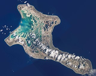
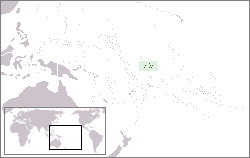
Kiritimati is a Pacific Ocean atoll in the northern Line Islands. It is part of the Republic of Kiribati. The name is derived from the English word "Christmas" written in Gilbertese according to its phonology, in which the combination ti is pronounced s.

<span class="mw-page-title-main">Line Islands</span> Chain of eleven atolls and low coral islands in the central Pacific Ocean

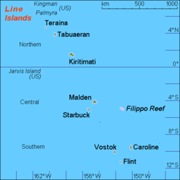
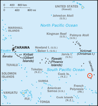
The Line Islands, Teraina Islands or Equatorial Islands are a chain of 11 atolls and coral islands in the central Pacific Ocean, south of the Hawaiian Islands. Eight of the atolls are parts of Kiribati. The remaining three—Jarvis Island, Kingman Reef, and Palmyra Atoll—are territories of the United States grouped with the United States Minor Outlying Islands. The Line Islands, all of which were formed by volcanic activity, are one of the longest island chains in the world, stretching 2,350 km (1,460 mi) from northwest to southeast. One of them, Starbuck Island, is near the geographic center of the Pacific Ocean. Another, Kiritimati, has the largest land area of any atoll in the world. Only Kiritimati, Tabuaeran, and Teraina have a permanent population. Besides the 11 confirmed atolls and islands, Filippo Reef is shown on some maps, but its existence is doubted.

<span class="mw-page-title-main">Malden Island</span> Island in the central Pacific Ocean

Malden Island, sometimes called Independence Island in the 19th century, is a low, arid, uninhabited atoll in the central Pacific Ocean, about 39 km2 (15 sq mi) in area. It is one of the Line Islands belonging to the Republic of Kiribati. The lagoon is entirely enclosed by land, though it is connected to the sea by underground channels, and is quite salty.

<span class="mw-page-title-main">Phoenix Islands</span> Central archipelago in Kiribati

The Phoenix Islands, or Rawaki, are a group of eight atolls and two submerged coral reefs that lie east of the Gilbert Islands and west of the Line Islands in the central Pacific Ocean, north of Samoa. They are part of the Republic of Kiribati. Their combined land area is 28 square kilometres (11 sq mi). The only island of any commercial importance is Canton Island. The other islands are Enderbury, Rawaki, Manra, Birnie, McKean, Nikumaroro, and Orona.

<span class="mw-page-title-main">Starbuck Island</span> Uninhabited coral island of eastern Kiribati

Starbuck Island is an uninhabited coral island in the central Pacific, and is part of the Central Line Islands of Kiribati. Its former names include "Barren Island", "Coral Queen Island", "Hero Island", "Low Island", and "Starve Island".

<span class="mw-page-title-main">Caroline Island</span> Coral atoll in the Pacific Ocean

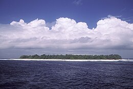
Caroline Island is the easternmost of several uninhabited coral atolls comprising the southern Line Islands in the central Pacific Ocean nation of Kiribati.

<span class="mw-page-title-main">Laysan</span> Atoll of Hawaii

Laysan is one of the Northwestern Hawaiian Islands, located 808 nautical miles northwest of Honolulu. It comprises one land mass of 1,016 acres (4.11 km2), about 1 by 1+12 miles in size. It is an atoll of sorts, although the land completely surrounds a shallow central lake some 2.4 m (7.9 ft) above sea level that has a salinity approximately three times greater than the ocean. Laysan's Hawaiian name, Kauō, means 'egg'.

<span class="mw-page-title-main">Black noddy</span> Species of bird

The black noddy, also known as white-capped noddy, is a species of tern in the family Laridae. It is a medium-sized seabird with black plumage and a white cap that closely resembles the lesser noddy with which it was at one time considered conspecific. The black noddy has slightly darker plumage and dark rather than pale lores.

<span class="mw-page-title-main">McKean Island</span> Uninhabited island of central Kiribati

McKean Island is a small, uninhabited island in the Phoenix Islands, Republic of Kiribati. Its area is 57 hectares.

<span class="mw-page-title-main">Fauna of the Cocos (Keeling) Islands</span> Native animals of the Cocos (Keeling) Islands

The terrestrial fauna of the Cocos (Keeling) Islands is unsurprisingly depauperate, because of the small land area of the islands, their lack of diverse habitats, and their isolation from large land-masses. However, the fauna dependent on marine resources is much richer.

<span class="mw-page-title-main">Atol das Rocas Biological Reserve</span>

Atol das Rocas Biological Reserve is a biological reserve in Brazil. The reserve is located on the Rocas Atoll, an atoll 144 miles north east of the Brazilian coast. It was created in 1979 to protect nesting sea turtles and migratory seabirds.

<span class="mw-page-title-main">Vatia, American Samoa</span> Village in American Samoa, United States

Vatia is a village on Tutuila Island in American Samoa. It is a north shore village located on Vatia Bay. The road to Vatia, American Samoa Highway 006, is the only road going through National Park of American Samoa. Vatia is a scenic community at the foot of Pola Ridge and surrounded by the national park. It is only reached by Route 6 which traverses the national park before reaching Vatia. There was once a hiking trail over Maugaloa Ridge from Leloaloa, but since the completion of Route 6, this trail is now overgrown. It is home to a beach, and panoramic views of jungle-covered peaks surround the village on all sides. Vatia is the center of the Tutuila-section of National Park of American Samoa. It is located in Vaifanua County.

<span class="mw-page-title-main">Central Polynesian tropical moist forests</span> Terrestrial ecoregion in central Polynesia

The Central Polynesian tropical moist forests is a tropical and subtropical moist broadleaf forests ecoregion in Polynesia. It includes the northern group of the Cook Islands, the Line Islands in Kiribati, and Johnston Atoll, Jarvis Island, Palmyra Atoll, and Kingman Reef which are possessions of the United States.

References

Notes

  1. The name means "East" in Russian. [1]

References

  1. 1 2 Armstrong, Terence (September 1971). "Bellingshausen and the discovery of Antarctica". Polar Record. 15 (99). Cambridge University Press: 887–889. doi:10.1017/S0032247400062112. S2CID   129664580.
  2. 1 2 3 Resture, Jane. "Vostok Island, Line Islands". janeresture.com. Retrieved 15 May 2015.
  3. 1 2 Clapp, Roger B.; Sibley, Fred C. (16 February 1971). "The vascular flora and terrestrial vertebrates of Vostok Island, South-Central Pacific" (PDF). Atoll Research Bulletin. 144: 1–9. doi:10.5479/si.00775630.144.1 . Retrieved 27 October 2021.
  4. The mystery behind Google Maps' 'black hole' in the Pacific Ocean, BBC, 5 Nov 2021
  5. Watkins, Doug; Batoromaio, Kiritian (2014). "Directory of Wetlands of Kiribati - 2014" (PDF). SPREP. p. 87. Retrieved 27 October 2021.
  6. 1 2 3 4 5 "Vostok Island's History Is Yet To Be Made". Pacific Islands Monthly. Vol. 37, no. 9. 1 September 1966. pp. 86–87. Retrieved 27 October 2021 via National Library of Australia.
  7. US Department of State Background Note
  8. Edward R. Lovell, Taratau Kirata & Tooti Tekinaiti (September 2002). "Status report for Kiribati's coral reefs" (PDF). Centre IRD de Nouméa. Retrieved 15 May 2015.
  9. Paine, James R. (1991). IUCN Directory of Protected Areas in Oceania. World Conservation Union. ISBN   978-0-8248-1217-1.
  10. 1 2 Warne, Kennedy (September 2014). "A World Apart – The Southern Line Islands". National Geographic. Archived from the original on 21 August 2017. Retrieved 15 May 2015.