Related Research Articles

Wakulla County is a county located in the Big Bend region in the northern portion of the U.S. state of Florida. As of the 2020 census, the population was 33,764. Its county seat is Crawfordville.

The Everglades is a natural region of flooded grasslands in the southern portion of the U.S. state of Florida, comprising the southern half of a large drainage basin within the Neotropical realm. The system begins near Orlando with the Kissimmee River, which discharges into the vast but shallow Lake Okeechobee. Water leaving the lake in the wet season forms a slow-moving river 60 miles (97 km) wide and over 100 miles (160 km) long, flowing southward across a limestone shelf to Florida Bay at the southern end of the state. The Everglades experiences a wide range of weather patterns, from frequent flooding in the wet season to drought in the dry season. Throughout the 20th century, the Everglades suffered significant loss of habitat and environmental degradation.

The Okefenokee Swamp is a shallow, 438,000-acre (177,000 ha), peat-filled wetland straddling the Georgia–Florida line in the United States. A majority of the swamp is protected by the Okefenokee National Wildlife Refuge and the Okefenokee Wilderness. The Okefenokee Swamp is considered to be one of the Seven Natural Wonders of Georgia and is the largest "blackwater" swamp in North America.

San Marcos de Apalache Historic State Park is a Florida State Park in Wakulla County, Florida organized around the historic site of a Spanish colonial fort, which was used by succeeding nations that controlled the area. The Spanish first built wooden buildings and a stockade in the late 17th and early 18th centuries here, which were destroyed by a hurricane.
The Woodville Karst Plain is a 450-square-mile (1,200 km2) karst area that runs from Tallahassee, Florida, U.S. to the Gulf of Mexico separated by the Cody Scarp.

Tallahassee Community College (TCC) is a public community college in Tallahassee, Florida. It is part of the Florida College System and is accredited by the Southern Association of Colleges and Schools. As of fall 2017, TCC reported 24,639 students. On July 1, 2024, the institution will be renamed to Tallahassee State College.
Peat swamp forests are tropical moist forests where waterlogged soil prevents dead leaves and wood from fully decomposing. Over time, this creates a thick layer of acidic peat. Large areas of these forests are being logged at high rates.

Panacea is an unincorporated community and census-designated place (CDP) in Wakulla County, Florida, United States. The population was 735 at the 2020 census, down from 816 at the 2010 census. It is part of the Tallahassee, Florida Metropolitan Statistical Area. The mule drawn and wooden railed Panacea Team brought tourists from Sopchoppy. It is home to Gulf Specimen Marine Lab and its nature center.

Newport is a small unincorporated community in Wakulla County, Florida, United States of America, situated where U.S. Highway 98 meets State Road 267.

Wakulla Springs is located 14 miles (23 km) south of Tallahassee, Florida and 5 miles (8.0 km) east of Crawfordville in Wakulla County, Florida at the crossroads of State Road 61 and State Road 267. It is protected in the Edward Ball Wakulla Springs State Park.

The Leon Sinks Geological Area is located on the Woodville Karst Plain in southern and southwestern Leon County, Florida, United States. It is a mature karstic area on the Upper Floridan Aquifer. It is one of the most extensive underwater cave systems in the world and connects to Wakulla Springs.

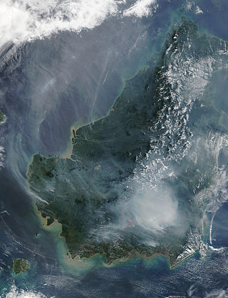
The Borneo peat swamp forests ecoregion, within the tropical and subtropical moist broadleaf forests biome, are on the island of Borneo, which is divided between Brunei, Indonesia and Malaysia.

The Tallahassee Metropolitan Area is the metropolitan area centered on Tallahassee, the capital of the U.S. state of Florida, located in Leon County the center of North Florida in the Florida panhandle.

Port Leon, Florida, was a river port town located in what is now Wakulla County, Florida. The town existed for only about six years in the first half of the 19th century. Port Leon is classified as an "extinct city" by the State Library and Archives of Florida, and only remnants can be found today.

Wakulla High School is the only public four year high school located in Wakulla County, Florida, United States. It is part of the Wakulla County Public Schools network. The Florida Department of Education has labeled Wakulla High School as a "School of Excellence" in their school accountability reports for the years 2020 and 2021.

The Wakulla State Forest is in the U.S. state of Florida. The 4,897-acre (20 km2) forest is located in the panhandle, near Tallahassee; it includes a major tract in Wakulla County and a small tract, the former Woodville State Forest, in Leon County. The forest is also a Wildlife Management Area managed by the Florida Fish and Wildlife Conservation Commission.

Before drainage, the Everglades, a region of tropical wetlands in southern Florida, were an interwoven mesh of marshes and prairies covering 4,000 square miles (10,000 km2). The Everglades is both a vast watershed that has historically extended from Lake Okeechobee 100 miles (160 km) south to Florida Bay, and many interconnected ecosystems within a geographic boundary. It is such a unique meeting of water, land, and climate that the use of either singular or plural to refer to the Everglades is appropriate. When Marjory Stoneman Douglas wrote her definitive description of the region in 1947, she used the metaphor "River of Grass" to explain the blending of water and plant life.
Fort Stansbury was a frontier outpost created during the Seminole War (1835—1842), and also used during the Civil War. The fort was located in current Wakulla County, Florida, in between Tallahassee and Wakulla Springs. It was headquarters for the U.S. 3rd Infantry Regiment. Its construction would have been typical of other forts built at the time, utilizing blockhouses and made from split pine trees. According to a contemporary account, of the 600 man garrison, a third became sick due to fever, dysentery, and other illness. The fort was occupied from, at the latest, September 1840, and abandoned by around April 1843. It was under the command of Lt. Colonel Ethan Allen Hitchcock from October 1842 until January 13, 1843. Despite there being no record of an artillery unit posted to the fort, the discovery of a jacket button belong to the Artillery Corps indicates that the fort may have been equipped with cannons or other large guns.
Edward Ball Wakulla Springs State Park is a Florida State Park in Wakulla County, Florida, United States. This 6,000 acre (24 km2) wildlife sanctuary, located south of Tallahassee, is listed on the National Register of Historic Places, and designated a National Natural Landmark.

A strand swamp or strand is a type of swamp in Florida that forms a linear drainage channel on flatlands. A forested wetland ecological habitat, strands occur on land areas with high water tables where the lack of slope prevents stream formation. Strands are more linear than the cypress dome swamps that form in more rounded depressions and are fairly similar to floodplain swamps that form further north along streams and rivers.
References
- ↑ J. William Yon (1966). "Geology of Jefferson County, Florida". Pages 66-68, The Myth of the Wakulla Volcano. Retrieved 2011-08-24.