Waldo, Kansas

Last updated

Waldo, Kansas
Russell County Kansas Incorporated and Unincorporated areas Waldo Highlighted.svg
Location within Russell County and Kansas
Map of Russell Co, Ks, USA.png
Coordinates: 39°7′13″N98°47′52″W / 39.12028°N 98.79778°W / 39.12028; -98.79778 [1]
Country United States
State Kansas
County Russell
Founded1888
Incorporated 1911
Area
[2]
  Total0.38 sq mi (0.97 km2)
  Land0.38 sq mi (0.97 km2)
  Water0.00 sq mi (0.00 km2)
Elevation
[1]
1,713 ft (522 m)
Population
 (2020) [3]
  Total30
  Density79/sq mi (31/km2)
Time zone UTC-6 (CST)
  Summer (DST) UTC-5 (CDT)
ZIP code
67673
Area code 785
FIPS code 20-74575
GNIS ID 472528 [1]

Waldo is a city in Waldo Township, Russell County, Kansas, United States. [1] As of the 2020 census, the population of the city was 30. [3]

Contents

History

The Union Town Company established the town of Waldo on October 1, 1888, having acquired 280 acres of land on a line of the Union Pacific Railroad. The community grew over the following decades, reaching a population of approximately 300 by 1915. A small business community, including a bank, stores, and three grain elevators, developed during the 1900s. [4] The town served as an agricultural shipping and receiving point for the surrounding area. [5] Waldo incorporated as a city in May 1911. [6]

Since the 1930s, the population of the community has gradually declined. Waldo High School closed in 1964, followed by Waldo Grade School in 1979. [6] In 1993, Union Pacific abandoned its rail line through Waldo, ending rail service to the community. [4]

Geography

Waldo is located on U.S. Route 281 in north-central Kansas 122 miles (196 km) northwest of Wichita, 224 miles (360 km) west of Kansas City, and 16 miles (26 km) north-northeast of Russell, the county seat. [7] [8]

Located in the Smoky Hills region of the Great Plains, Waldo sits on the east bank of the West Fork of Wolf Creek, part of the Saline River watershed. [7]

According to the United States Census Bureau, the city has a total area of 0.36 square miles (0.93 km2), all of it land. [9]

Demographics

Historical population
CensusPop.Note
1920 246
1930 27913.4%
1940 257−7.9%
1950 216−16.0%
1960 178−17.6%
1970 123−30.9%
1980 75−39.0%
1990 57−24.0%
2000 48−15.8%
2010 30−37.5%
2020 300.0%
U.S. Decennial Census

2010 census

As of the 2010 census, there were 30 people, 15 households, and 7 families residing in the city. The population density was 75 people per square mile (29/km2). There were 44 housing units at an average density of 110 per square mile (44/km2). The racial makeup of the city was 100.0% White. Hispanics and Latinos of any race were 0.0% of the population. [10]

There were 15 households, of which 20.0% had children under the age of 18 living with them, 46.7% were married couples living together, 0.0% had a male householder with no wife present, 0.0% had a female householder with no husband present, and 53.3% were non-families. 53.3% of all households were made up of individuals, and 60.0% had someone living alone who was 65 years of age or older. The average household size was 2.00, and the average family size was 3.14. [10]

In the city, the population was spread out, with 26.7% under the age of 18, 0.0% from 18 to 24, 20.0% from 25 to 44, 20.0% from 45 to 64, and 33.3% who were 65 years of age or older. The median age was 52.0 years. For every 100 females, there were 114.3 males. For every 100 females age 18 and over, there were 100 males age 18 and over. [10]

The median income for a household in the city was $37,857, and the median income for a family was $38,393. The per capita income for the city was $15,152. There were 0.0% of families and 0.0% of the population living below the poverty line. [10]

2000 census

As of the census [11] of 2000, there were 48 people, 27 households, and 15 families residing in the city. The population density was 126.0 inhabitants per square mile (48.6/km2). There were 32 housing units at an average density of 84.0 per square mile (32.4/km2). The racial makeup of the city was 95.83% White, 2.08% Native American, and 2.08% from two or more races.

There were 27 households, out of which 14.8% had children under the age of 18 living with them, 48.1% were married couples living together, 3.7% had a female householder with no husband present, and 44.4% were non-families. 44.4% of all households were made up of individuals, and 18.5% had someone living alone who was 65 years of age or older. The average household size was 1.78 and the average family size was 2.40.

In the city the population was spread out, with 12.5% under the age of 18, 12.5% from 18 to 24, 8.3% from 25 to 44, 29.2% from 45 to 64, and 37.5% who were 65 years of age or older. The median age was 62 years. For every 100 females, there were 108.7 males. For every 100 females age 18 and over, there were 121.1 males.

Economy

As of 2012, 37.0% of the population over the age of 16 was in the labor force. 0.0% was in the armed forces, and 37.0% was in the civilian labor force with 37.0% being employed and 0.0% unemployed. The composition, by occupation, of the employed civilian labor force was: 60.0% in management, business, science, and arts; 30.0% in sales and office occupations; 10.0% in natural resources, construction, and maintenance; 0.0% in production, transportation, and material moving; and 0.0% in service occupations. The three industries employing the largest percentages of the working civilian labor force were: agriculture, forestry, fishing and hunting, and mining (40.0%); educational services, and health care and social assistance (30.0%); and retail trade (20.0%). [10]

The cost of living in Waldo is relatively low; compared to a U.S. average of 100, the cost of living index for the community is 79.9. [12] As of 2012, the median home value in the city was $13,800, and the median selected monthly owner cost was $467 for housing units with a mortgage and $313 for those without. [10]

Government

Waldo is a city of the third class with a mayor-council form of government. The city council consists of five members, and it meets on the first Tuesday of each month. [13]

Waldo lies within Kansas's 1st U.S. Congressional District. For the purposes of representation in the Kansas Legislature, the city is located in the 36th district of the Kansas Senate and the 109th district of the Kansas House of Representatives. [13]

Education

Waldo lies within USD 399, based in nearby Natoma. [14] [15]

Waldo High School consolidated with Paradise High School in 1964. Paradise High School then consolidated with Natoma High School in 1974. The Waldo High School mascot was Waldo Warriors. [16]

Infrastructure

Transportation

U.S. Route 281 and Kansas Highway 18 (K-18) run concurrently east–west through Waldo. [7]

Utilities

Western Electric provides electricity to local residents. Gorham Telephone provides landline telephone service and offers cable television and internet access. [17] Most residents use privately stored propane for heating fuel. [12] [17]

Media

Waldo is in the Wichita-Hutchinson, Kansas television market. [18]

Related Research Articles

<span class="mw-page-title-main">Russell County, Kansas</span> County in Kansas, United States

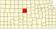
Russell County is a county in the U.S. state of Kansas. Its county seat and largest city is Russell. As of the 2020 census, the population was 6,691. The county was named for Avra Russell. The city of Russell was the home of former U.S. Senate Majority leader and 1996 GOP presidential nominee Bob Dole for many years.

<span class="mw-page-title-main">Sharon, Kansas</span> City in Kiowa County, Kansas

Sharon is a city in Barber County, Kansas, United States. As of the 2020 census, the population of the city was 147.

<span class="mw-page-title-main">Rantoul, Kansas</span> City in Franklin County, Kansas

Rantoul is a city in Franklin County, Kansas, United States. As of the 2020 census, the population of the city was 165.

<span class="mw-page-title-main">Quinter, Kansas</span> City in Gove County, Kansas

Quinter is a city in Gove County, Kansas, United States. As of the 2020 census, the population of the city was 929.

<span class="mw-page-title-main">Copeland, Kansas</span> City in Gray County, Kansas

Copeland is a city in Gray County, Kansas, United States. As of the 2020 census, the population of the city was 251.

<span class="mw-page-title-main">Formoso, Kansas</span> City in Jewell County, Kansas

Formoso is a city in Jewell County, Kansas, United States. As of the 2020 census, the population of the city was 94.

<span class="mw-page-title-main">Mound City, Kansas</span> City and County seat in Kansas, United States

Mound City is a city in and the county seat of Linn County, Kansas, United States. As of the 2020 census, the population of the city was 647.

<span class="mw-page-title-main">Natoma, Kansas</span> City in Osborne County, Kansas

Natoma is a city in Osborne County, Kansas, United States. As of the 2020 census, the population of the city was 302.

<span class="mw-page-title-main">Rozel, Kansas</span> City in Pawnee County, Kansas, United States

Rozel is a city in Pawnee County, Kansas, United States. As of the 2020 census, the population of the city was 102.

<span class="mw-page-title-main">Kirwin, Kansas</span> City in Phillips County, Kansas

Kirwin is a city in Phillips County, Kansas, United States. As of the 2020 census, the population of the city was 139.

<span class="mw-page-title-main">Prairie View, Kansas</span> City in Phillips County, Kansas

Prairie View is a city in Phillips County, Kansas, United States. As of the 2020 census, the population of the city was 106.

<span class="mw-page-title-main">Speed, Kansas</span> City in Phillips County, Kansas

Speed is a city in Phillips County, Kansas, United States. As of the 2020 census, the population of the city was 37.

<span class="mw-page-title-main">Sawyer, Kansas</span> City in Pratt County, Kansas

Sawyer is a city in Pratt County, Kansas, United States. As of the 2020 census, the population of the city was 89.

<span class="mw-page-title-main">Narka, Kansas</span> City in Republic County, Kansas

Narka is a city in Republic County, Kansas, United States. As of the 2020 census, the population of the city was 81.

<span class="mw-page-title-main">Paradise, Kansas</span> City in Russell County, Kansas

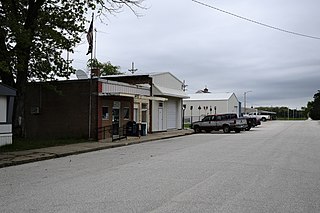
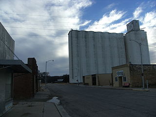
Paradise is a city in Russell County, Kansas, United States. As of the 2020 census, the population of the city was 35.

<span class="mw-page-title-main">Kensington, Kansas</span> City in Smith County, Kansas

Kensington is a city in Smith County, Kansas, United States. As of the 2020 census, the population of the city was 399.

<span class="mw-page-title-main">Haddam, Kansas</span> City in Washington County, Kansas

Haddam is a city in Washington County, Kansas, United States. It is named after Haddam, Connecticut. As of the 2020 census, the population of the city was 110.

<span class="mw-page-title-main">Hollenberg, Kansas</span> City in Washington County, Kansas

Hollenberg is a city in Washington County, Kansas, United States. As of the 2020 census, the population of the city was 10. It is located 1.5 miles south of the Nebraska state line.

<span class="mw-page-title-main">Paradise Township, Russell County, Kansas</span> Township in Kansas, United States

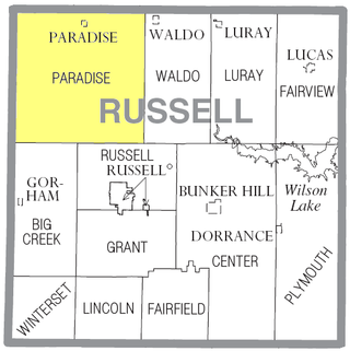
Paradise Township is a township in Russell County, Kansas, United States. As of the 2010 United States Census, it had a population of 166.

<span class="mw-page-title-main">Waldo Township, Russell County, Kansas</span> Township in Kansas, United States

Waldo Township is a township in Russell County, Kansas, United States. As of the 2010 United States Census, it had a population of 78. It includes the town of Waldo.

References

  1. 1 2 3 4 "Waldo, Kansas", Geographic Names Information System , United States Geological Survey, United States Department of the Interior
  2. "2019 U.S. Gazetteer Files". United States Census Bureau. Retrieved July 24, 2020.
  3. 1 2 "Profile of Waldo, Kansas in 2020". United States Census Bureau. Archived from the original on March 21, 2022. Retrieved March 21, 2022.
  4. 1 2 Clow, Albert (January 10, 2003). "History". City of Waldo, Kansas. Archived from the original on October 14, 2012. Retrieved August 15, 2011.
  5. Blackmar, Frank W., ed. (1912). "Waldo". Kansas: a cyclopedia of state history, embracing events, institutions, industries, counties, cities, towns, prominent persons, etc. Vol. 2. Chicago: Standard. p. 859.
  6. 1 2 Clow, Albert (April 17, 2011). "City of Waldo, Kansas". City of Waldo, Kansas. Archived from the original on November 6, 2011. Retrieved August 15, 2011.
  7. 1 2 3 "General Highway Map - Russell County, Kansas" (PDF). Kansas Department of Transportation. October 1, 2010. Retrieved December 12, 2010.
  8. "City Distance Tool". Geobytes. Archived from the original on October 5, 2010. Retrieved October 23, 2010.
  9. "US Gazetteer files 2010". United States Census Bureau . Retrieved July 6, 2012.
  10. 1 2 3 4 5 6 "U.S. Census website". United States Census Bureau . Retrieved August 8, 2011.
  11. "U.S. Census website". United States Census Bureau . Retrieved January 31, 2008.
  12. 1 2 "Waldo, Kansas". City-Data.com. Retrieved September 11, 2014.
  13. 1 2 "Waldo". Directory of Kansas Public Officials. The League of Kansas Municipalities. Retrieved August 8, 2011.
  14. "Kansas Unified School Districts (map)" (PDF). Kansas State Department of Education. Archived from the original (PDF) on July 21, 2011. Retrieved August 5, 2011.
  15. "Paradise USD 399". USD 399. Retrieved January 4, 2017.
  16. "New Pilot For Waldo Warriors", The Salina Journal, 2 December 1954, p.15.
  17. 1 2 "Utilities". Russell County, Kansas Economic Development & CVB. Retrieved September 11, 2014.
  18. "Kansas". TV Market Maps. EchoStar Knowledge Base. Retrieved September 11, 2014.

Further reading