The Sierra Nevada is a mountain range in the Western United States, between the Central Valley of California and the Great Basin. The vast majority of the range lies in the state of California, although the Carson Range spur lies primarily in Nevada. The Sierra Nevada is part of the American Cordillera, an almost continuous chain of mountain ranges that forms the western "backbone" of the Americas.

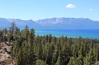
Lake Tahoe is a freshwater lake in the Sierra Nevada of the United States. Lying at 6,225 ft (1,897 m), it straddles the state line between California and Nevada, west of Carson City. Lake Tahoe is the largest alpine lake in North America, and at 122,160,280 acre⋅ft (150.7 km3) it trails only the five Great Lakes as the largest by volume in the United States. Its depth is 1,645 ft (501 m), making it the second deepest in the United States after Crater Lake in Oregon.
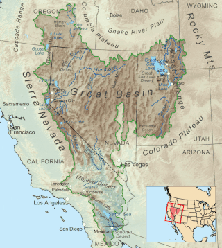
The Great Basin is the largest area of contiguous endorheic watersheds, those with no outlets, in North America. It spans nearly all of Nevada, much of Utah, and portions of California, Idaho, Oregon, Wyoming, and Baja California. It is noted for both its arid climate and the basin and range topography that varies from the North American low point at Badwater Basin in Death Valley to the highest point of the contiguous United States, less than 100 miles (160 km) away at the summit of Mount Whitney. The region spans several physiographic divisions, biomes, ecoregions, and deserts.

The Truckee River is a river in the U.S. states of California and Nevada. The river flows northeasterly and is 121 miles (195 km) long. The Truckee is the sole outlet of Lake Tahoe and drains part of the high Sierra Nevada, emptying into Pyramid Lake in the Great Basin. Its waters are an important source of irrigation along its valley and adjacent valleys.

The Walker River is a river in west-central Nevada in the United States, approximately 62 miles (100 km) long. Fed principally by snowmelt from the Sierra Nevada of California, it drains an arid portion of the Great Basin southeast of Reno and flows into the endorheic basin of Walker Lake. The river is an important source of water for irrigation in its course through Nevada; water diversions have reduced its flow such that the level of Walker Lake has fallen 160 feet (49 m) between 1882 and 2010. The river was named for explorer Joseph Reddeford Walker, a mountain man and experienced scout who is known for establishing a segment of the California Trail.

The East Walker River is an approximately 90 miles (140 km) long, tributary of the Walker River, in eastern California and western Nevada in the United States. It drains part of the eastern side of the Sierra Nevada in the watershed of Walker Lake in the Great Basin.

Walker Lake is a natural lake in the Great Basin in western Nevada in the United States. It is 11 mi (17 km) long and 5 mi (8 km) wide, in northwestern Mineral County along the east side of the Wassuk Range, about 75 mi (120 km) southeast of Reno. The lake is fed from the north by the Walker River and has no natural outlet except absorption and evaporation. The community of Walker Lake is found along the southwest shore.
The protected areas of Michigan come in an array of different types and levels of protection. Michigan has five units of the National Park Service system. There are 14 federal wilderness areas; the majority of these are also tribal-designated wildernesses. It has one of the largest state forest systems as well having four national forests. The state maintains a large state park system and there are also regional parks, and county, township and city parks. Still other parks on land and in the Great Lakes are maintained by other governmental bodies. Private protected areas also exist in the state, mainly lands owned by land conservancies.

Walker Lake State Recreation Area is a recreation area of Nevada, United States, located on the west shore of Walker Lake. The area was previously protected as a Nevada State Park. It is situated is within the Great Basin, and the Central Nevada Region of the Nevada State Parks system. Walker Lake State Recreation Area is located north of the town of Hawthorne, on U.S. Route 95 in Nevada.

The California Natural Resources Agency (CNRA) is a state cabinet-level agency in the government of California. The institution and jurisdiction of the Natural Resources Agency is provided for in California Government Code sections 12800 and 12805, et seq. The Agency has six departments, 10 conservancies, 17 boards and commissions, three councils, and one urban park in Los Angeles that consists of two museums, the California Science Center and the California African American museum. Through its 25 departments, conservancies and commissions, the Natural Resources Agency is responsible for protecting prehistory history, natural landscapes and cultural sites, monitoring and stewarding state lands and waterways, and regulating fish and game use, as well as private lands and the intersection with federal lands and waters.
The American Land Conservancy was an American non-profit organization who's goal was to protect the natural environment.
The Central Utah Project is a US federal water project that was authorized for construction under the Colorado River Storage Project Act of April 11, 1956, as a participating project. In general, the Central Utah Project develops a portion of Utah's share of the yield of the Colorado River, as set out in the Colorado River Compact of 1922.

According to the California Protected Areas Database (CPAD), in the state of California, United States, there are over 14,000 inventoried protected areas administered by public agencies and non-profits. In addition, there are private conservation areas and other easements. They include almost one-third of California's scenic coastline, including coastal wetlands, estuaries, beaches, and dune systems. The California State Parks system alone has 270 units and covers 1.3 million acres (5,300 km2), with over 280 miles (450 km) of coastline, 625 miles (1,006 km) of lake and river frontage, nearly 18,000 campsites, and 3,000 miles (5,000 km) of hiking, biking, and equestrian trails.
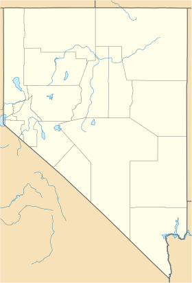
Western Nevada (WNV) is a region and the northwestern portion of the U.S. state of Nevada that includes Reno, Carson City, Carson Valley and Virginia City. Lyon County and Churchill County are sometimes also referred to as part of Western Nevada.
The Desert Terminal Lakes Program, enacted in Section [?] of the 2002 farm bill, authorizes the transfer of $200 million from the Commodity Credit Corporation (CCC) to the Bureau of Reclamation to provide water to "at risk natural desert terminal lakes."

Bridgeport Reservoir is a lake at the lower end of Bridgeport Valley in Mono County, California. Its earth-filled dam was constructed in 1923 by the Walker River Irrigation District, along the East Walker River. The lake has a storage capacity of 42,455 acre-feet (52,367,000 m3) and is regulated by a Federal Watermaster supplying primarily agricultural irrigation and flood control for Lyon County, Nevada.
Van Sickle Bi-State Park is a public recreation area straddling the border of California and Nevada, United States, that overlooks Lake Tahoe and preserves the memory of Henry Van Sickle, a key member in the founding of Genoa and the surrounding area. The state park features trails for hiking, mountain biking, and horseback riding. It is managed by the Nevada Division of State Parks in partnership with the California Tahoe Conservancy.
The Fonta Flora State Trail is a unit of the North Carolina state park system in Buncombe, McDowell, and Burke Counties, North Carolina in the United States, and it consists of 90 acres (36 ha) of conservation land and 19 miles (31 km) designated multi-use trail. The State Trail is planned as a continuous route for hikers and cyclists from Asheville to Morganton, with a loop around Lake James. The trail is a collaboration between local governments, local land conservancies the US Forest Service, and the state, with development coordinated by the North Carolina Division of Parks and Recreation (NCDPR).

Independence Lake is a natural glacial lake in the Sierra Nevada of California. At an elevation of 6,949 feet (2,118 m) in the upper reaches of the Truckee River basin, it has been less affected by development than most lakes in the area. The Nature Conservancy owns a 2,325 acres (9.41 km2) parcel of land around it, which it manages privately as the Independence Lake Preserve for the purposes of conservation and low-impact recreation.