Davidson County is a county located in the U.S. state of North Carolina. As of the 2020 census, the population was 168,930. Its county seat is Lexington, and its largest community is Thomasville.
Graham is a city in Alamance County, North Carolina, United States. It is part of the Burlington, North Carolina Metropolitan Statistical Area. As of the 2020 census the population was 17,153. It is the county seat of Alamance County.

Warsaw is a town in Duplin County, North Carolina, United States. The population was 3,054 at the 2010 census.

Oxford is a town in Granville County, North Carolina, United States, with a population of 8,628 as of the 2020 census. It is the county seat of Granville County.

Oak Ridge is a town in northwestern Guilford County, North Carolina, United States. As of the census of 2020, the town had a population of 7,474. Oak Ridge is 15 miles (24 km) northwest of the center of Greensboro, North Carolina's third-most populous city. Oak Ridge is a part of the Piedmont Triad urban area.

Summerfield is a town in Guilford County, North Carolina. As of the 2020 census, the population was 10,951.

Erwin is a town that is located in the eastern part of Harnett County, North Carolina, United States, located approximately 5 miles (8.0 km) from Dunn and approximately 20 miles (32 km) from Fayetteville. The city is a part of the Dunn, NC Micropolitan Statistical Area, which is additionally a part of the greater Raleigh-Durham-Cary, NC CSA, according to the United States Census Bureau. Currently, the city has a population of 5,270 as of the 2020 census. Its current mayor is Randy Baker, who has been the mayor since being elected on May 17, 2022.

Sanford is a city in Lee County, North Carolina, United States. The population was 30,261 at the 2020 census. It is the county seat of Lee County. The geographic center of North Carolina is located northwest of the city, in Chatham County.
Cornelius is a suburban town located along Lake Norman in northern Mecklenburg County, North Carolina, United States. It is a major suburb in the Charlotte metropolitan area. The population was 24,866 at the 2010 census.

Hertford is a town and the county seat of Perquimans County, North Carolina, United States. The current population of Hertford, North Carolina is 1,912 based on the 2020 census. The US Census estimates the 2021 population at 1,925. The last official US Census in 2010 recorded the population at 2,143. Hertford is located in North Carolina's Inner Banks region and is part of both the Elizabeth City Micropolitan Statistical Area and the Hampton Roads region. It is named after the county town of Hertford, England.
Newton Grove is a town in Sampson County, North Carolina, United States. It was chartered in 1879. The population was 585 at the 2020 census.
Wilkesboro is a town in and the county seat of Wilkes County, North Carolina, United States. The population was 3,687 at the 2020 census. The town is located along the south bank of the Yadkin River, directly opposite the town of North Wilkesboro. Wilkesboro is a Small Town Main Street community and has recently revitalized its historic downtown to include the Carolina West Wireless Community Commons, Wilkes Communications Pavilion, Heritage Square and Splash Pad. Cub Creek Park is adjacent to the downtown and contains many amenities, which include baseball, walking trails, mountain biking trails, trout fishing, dog park, basketball, tennis, and pickleball courts, picnic shelters, etc. Wilkesboro is also the home of the annual MerleFest, Carolina in the Fall, and Brushy Mountain Peach & Heritage festivals.
Thomasville is a city in Davidson County, North Carolina, United States. The population was 27,183 at the 2020 census. The city was once notable for its furniture industry, as were its neighbors High Point and Lexington. This Piedmont Triad community was established in 1852 and hosts the state's oldest festival, "Everybody's Day".

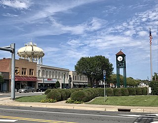
Kernersville is a town in Forsyth County, North Carolina, and the largest suburb of Winston-Salem. A small portion of the town is also in Guilford County. The population was 26,481 at the 2020 census, up from 23,123 in 2010. Kernersville is located at the center of the Piedmont Triad metropolitan area, between Greensboro to the east, High Point to the south, and Winston-Salem to the west. Some of the farmland surrounding the town has been sold and turned into large middle-to-upper-class housing developments.

Davidson is a suburban town located in Iredell and Mecklenburg counties, North Carolina, United States, on the banks of Lake Norman. It is a suburb in the Charlotte metropolitan area. The population was 10,944 at the 2010 census, and in 2019 the estimated population was 13,054. The town was founded in 1837 with the establishment of the Presbyterian Davidson College, named for Brigadier General William Lee Davidson, a local Revolutionary War hero. The land for Davidson College came from Davidson's estate, a large portion of which was donated by his son.
Iron Station is an unincorporated community and census-designated place (CDP) in Lincoln County, North Carolina, United States. A primarily industrial town, Iron Station's population was 755 as of the 2010 census. It also serves as a bedroom community for the larger cities of Charlotte, Hickory, and Lincolnton.
Tyro is an unincorporated community and census-designated place (CDP) located 7 miles (11 km) west of Lexington and 24 miles (39 km) south of Winston-Salem in Davidson County, North Carolina, United States. As of the 2020 census, the community had a population of 8,926.
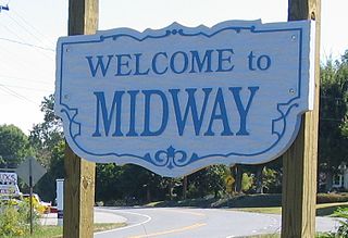
Midway is a town in Davidson County, North Carolina, United States. It is located within the township of the same name. As of the 2020 census, Midway had a population of 4,742. Midway is situated approximately 275 metres (902 ft) above sea level. Midway is part of the Piedmont Triad region and is neighbored by the communities of Arcadia (west), Welcome (south), Wallburg (northeast) and Winston-Salem (north). Every autumn, the town hosts the Midway Christmas Parade in celebration of the coming Christmas season.
Advance is an unincorporated community and census-designated place (CDP) in Davie County, North Carolina, United States. It is seventy-five miles northeast of Charlotte. As of the 2010 census it had a population of 1,138. It is located along North Carolina Highway 801 just south of Bermuda Run. Advance is part of the Piedmont Triad region of North Carolina.
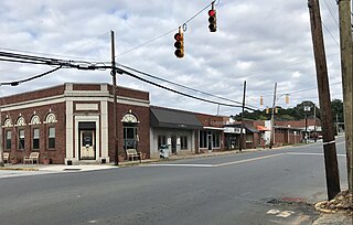
Denton is a town in Davidson County, North Carolina, United States. As of the 2020 census, the population of the town was 1,494.