Walls of Basel

Last updated
Map of Basel city walls Karte Basler Stadtmauer.png
Map of Basel city walls

The Basel city walls are a complex of walls surrounding the central part of the Swiss city of Basel, only partially preserved today. The first city wall was completed around 1080 under bishop Burkhard von Fenis. A newer wall was constructed around 1230, which is known as the Inner Wall. Its course was mostly identical to the Burkhard wall. In 1362 the construction of a larger wall complex began due to the city's expansion; it was completed in 1398, and is known as the Outer Wall. In 1859 the city's executives decided to raze the inner wall and gates to the ground. Three outer city gates and a short piece of the wall were saved from demolition and are being preserved as part of the city's heritage.

Contents

History

Old city wall at Letziplatz Basel-Stadtmauer.jpg
Old city wall at Letziplatz

At the end of the 11th century, the growing settlement in the valley was walled, though settlement continued outside the wall. [1] As the town spread up the west slopes surrounding the Birsig river, that section was walled also. [1] At the beginning of the 13th century, all these sections were included within a single wall that embraced both the valley and hill settlements. In 1362, the city began building a new, wider city wall, which also enclosed the suburbs. It is possible that the destruction wrought by the earthquake of 1356 contributed to the decision to build a new wall. Among the construction materials were debris from the destruction and Jewish gravestones from the cemetery of the first Jewish community of Basel, [2] which was destroyed in the violence surrounding the outbreak of the Black Death in 1348. The construction of the outer city walls was completed in 1398 and these walls lasted until the mid-nineteenth century. [1]

In 1859, the city walls were demolished in order to increase space and improve hygiene conditions in the city. The debris from the demolished walls were used to fill in the city moat, and these areas were converted into new streets and spaces, many of which bear names referring to the original wall. During this process, most of the embedded gravestones were lost. Ten of the few remaining ones are on display in the courtyard of the Jewish Museum of Switzerland. [3]

City gates

Outer gates

Three gates from the outer wall have been preserved, and today they represent landmarks of Basel and a heritage site of national significance: [4]

Inner gates

The inner walls used to encircle the Great Basel (Gross Basel) on the west bank and Small Basel (Kleinbasel) on the east bank of the Rhine. All the inner gates and walls were demolished between 1860 and 1870:

East bank

Aeschenschwibbogen, an 1841 watercolour Aeschenschwibbogen-aquarelle-1841.jpg
Aeschenschwibbogen, an 1841 watercolour
  • Aeschenschwibbogen was a small gate near the east bank of the Birsig. Aesch is a village about 8 km (5.0 mi) south of Basel old town. (It is nowadays a suburb of the city.) A Schwibbogen  [ de ] is a type of buttress, in the form of an arch which braces the structures on either side. Aeschenschwibbogen was first documented in 1261 as 'Eschmertor', in connection with a donation to Saint Urban's Abbey. Later names include 'Aeschentor' and 'Inneres Aeschentor'. Its original function became obsolete in the 14th century when the outer city wall was built, and that function was taken over by the Aeschentor in the outer wall. The upper half of the tower was removed in August 1545, after a crack in the masonry appeared. The gate is recorded as having been equipped with a clock from the middle of the 16th century.
In August 1839, Rudolf Forcart-Hoffmann, a manufacturer of passementerie, petitioned the Kleiner Rat  [ de ] ('Lesser Council') of Basel that Aeschenschwibbogen should be demolished. He wanted to build a new house, Schilthof  [ als ], at the location. This would serve a double purpose: beautifying the city, and removing a bottleneck on an important traffic route. Permission was granted, and Aeschenschwibbogen was demolished in 1841. [5] [6] [7] [8]

  • The Steinentor (Gate of Steinen) was pulled down in 1866 along with most of the city walls.
  • The Rheintor (Rhine Gate) was pulled down in 1839, about twenty years before the other city walls. It was located at the Rhine bridge on the western river bank.

West bank

  • The Riehentor (Gate of Riehen) was pulled down in 1864.
  • The Bläsitor (Gate of Saint Blaise) was pulled down in 1867.

Other wall buildings

See also

Related Research Articles

<span class="mw-page-title-main">Basel</span> City in Switzerland

Basel, also known as Basle, is a city in northwestern Switzerland on the river Rhine. Basel is Switzerland's third-most-populous city, with 177,595 inhabitants within the city municipality limits. The official language of Basel is German, and the main spoken language is the local Basel German dialect.

<span class="mw-page-title-main">Basel-Stadt</span> Canton of Switzerland

Basel-Stadt or Basel-City is one of the 26 cantons forming the Swiss Confederation. It is composed of three municipalities with Basel as the capital. It is traditionally considered a "half-canton", the other half being Basel-Landschaft, its rural counterpart.

<span class="mw-page-title-main">Battle of St. Jakob an der Birs</span> 1444 battle of the Old Zürich War

The Battle of St. Jakob an der Birs was fought between the Old Swiss Confederacy and French mercenaries, on the banks of the river Birs. The battle took place on 26 August 1444 and was part of the Old Zürich War. The site of the battle was near Münchenstein, Switzerland, just over 1 km outside the city walls of Basel, today within Basel's St-Alban district.

<span class="mw-page-title-main">Andernach</span> Town in Rhineland-Palatinate, Germany

Andernach is a town in the district of Mayen-Koblenz, in Rhineland-Palatinate, Germany, of about 30,000 inhabitants. It is situated towards the end of the Neuwied basin on the left bank of the Rhine between the former tiny fishing village of Fornich in the north and the mouth of the small river Nette in the southeast, just 13 miles (21 km) north of Koblenz, with its five external town districts: Kell, Miesenheim, Eich, Namedy, and Bad Tönisstein.

<span class="mw-page-title-main">Sankt Goar</span> Town in Rhineland-Palatinate, Germany

Sankt Goar is a town on the west bank of the Middle Rhine in the Rhein-Hunsrück-Kreis (district) in Rhineland-Palatinate, Germany. It belongs to the Verbandsgemeinde Hunsrück-Mittelrhein, whose seat is in Emmelshausen.

Between the 12th century and modern times, the Swiss city of Basel has been home to three Jewish communities. The medieval community thrived at first but ended violently with the Basel massacre of 1349. As with many of the violent anti-Judaic events of the time, it was linked to the outbreak of the Black Death. At the end of the 14th century, a second community formed. But it was short-lived and disbanded before the turn of the century. For the following 400 years, there was no Jewish community in Basel. Today, there are several communities, ranging from liberal to religious to orthodox, and there are still more Jews who don’t belong to any community.

<span class="mw-page-title-main">Waldshut-Tiengen</span> Town in Baden-Württemberg, Germany

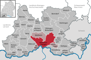
Waldshut-Tiengen, commonly known as Waldshut, is a city in southwestern Baden-Württemberg right at the Swiss border. It is the district seat and at the same time the biggest city in Waldshut district and a "middle centre" in the area of the "high centre" Lörrach/Weil am Rhein to whose middle area most towns and communities in Waldshut district belong. There are furthermore complexities arising from cross-border traffic between this area and the Swiss cantons of Aargau, Schaffhausen and Zürich. This classification relates to Walter Christaller's Central Place Theory, however, and not to any official administrative scheme.

Baselland Transport AG (BLT) is a Swiss public transport operator in the cantons of Basel-Land, Basel-Stadt, Solothurn and in France. The BLT was founded in 1974, and is owned by the Canton of Basel-Land, located to the south of the city. It transports some 48 million passengers per year, using a fleet of 64 buses and 100 trams over a network of 165 kilometres (103 mi) of bus routes and 65 kilometres (40 mi) of tram routes.

<span class="mw-page-title-main">Basel SBB railway station</span> Train stop in northwestern Switzerland

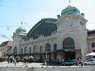
Basel SBB railway station is the central railway station in the city of Basel, Switzerland. Opened in 1854, and completely rebuilt in 1900–1907, it is Europe's busiest international border station. Basel SBB is owned by the Swiss Federal Railways (SBB CFF FFS). The other major railway station is Basel Badischer Bahnhof, operated by the German railway company Deutsche Bahn, on the north side of the Rhine from the city centre.

<span class="mw-page-title-main">Basel Minster</span> Church

Basel Minster is a religious building in the Swiss city of Basel, originally a Catholic cathedral and today a Reformed Protestant church.

<span class="mw-page-title-main">Villa Merian</span>

The Villa Merian, with its English Garden, stands on the elevated plain above Brüglingen in Münchenstein, in the canton of Basel-Country in Switzerland.

<span class="mw-page-title-main">Developments at Zoo Basel</span> Zoo in Basel, Switzerland

The Zoo Basel is constantly upgrading its infrastructure, but can hardly grow in area, as it is surrounded by the city of Basel, Switzerland, and, in the south, by Binningen. While most projects are upgrading older infrastructure and constructing multiple-animal exhibits, the zoo has plans to expand in area as well.

<span class="mw-page-title-main">Trams in Basel</span>

The Basel tramway network is a network of tramways forming part of the public transport system in Basel, Switzerland, and its agglomeration - it also reaches into adjacent suburbs in Germany and France. The only two other tramway networks to cross an international border are Geneva's and Strasbourg's tramways. The Basel tram system consists of 12 lines. Due to its longevity, it is part of Basel's heritage and, alongside the Basel Minster, is one of the symbols of the city.

<span class="mw-page-title-main">Aesch Castle</span> Castle in Aesch, Basel-Country, Switzerland

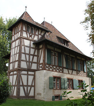
Aesch Castle or Blarer Castle is a castle in the Swiss municipality of Aesch in the canton of Basel-Country.

<span class="mw-page-title-main">Gundeldingen Castle</span>

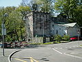
Gundeldingen Castle is a castle in the Gundeldingen neighborhood of the municipality of Basel of the Canton of Basel-Stadt in Switzerland. It is a Swiss heritage site of national significance. Originally four related castles, today parts of only two remain.

<span class="mw-page-title-main">Pfeffingen Castle</span>

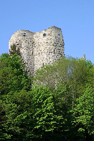
Pfeffingen Castle is a castle in the municipality of Pfeffingen of the canton of Basel-Land in Switzerland. It is a Swiss heritage site of national significance.

<span class="mw-page-title-main">Karlstor</span>

Karlstor in Munich is a medieval city gate, which served as a defensive fortification and a checkpoint.

The following is a timeline of the history of the city of Basel.

<span class="mw-page-title-main">Fortifications of Frankfurt</span> System of military defences of Frankfurt am Main

The fortifications of Frankfurt were a system of military defences of the German city of Frankfurt am Main which existed from the Middle Ages into the 19th century. Around 1000 the first city wall was built. It enclosed the area of what is now the Königspfalz in modern Frankfurt. In the twelfth century the settlement expanded into what is now Altstadt. For its protection an additional wall, the Staufenmauer, was erected. Starting in 1333, the Neustadt suburb developed north of the Altstadt and was encompassed by an additional wall with five gates. In the fifteenth century, a "landwehr border" was created around the entire territory of the Free City of Frankfurt. Beginning in 1628, the medieval city wall was developed to form a bastion fortress under the municipal architect Johann Dilich.

References

  1. 1 2 3 Dickinson, Robert. The West European City: A Geographical Interpretation , Volume 12, pp.66-67 (Taylor & Francis 1998).
  2. Tonjola, Johannes (1661). Basilea Sepulta. Basel. p. 1.
  3. Battegay, Lubrich, Caspar, Naomi (2018). Jewish Switzerland: 50 Objects Tell Their Stories. Jewish Museum of Switzerland / Christoph Merian Verlag. ISBN   978-3-85616-847-6.{{cite book}}: CS1 maint: multiple names: authors list (link)
  4. Swiss inventory of cultural property of national and regional significance (1995), p. 78.
  5. "Aeschenschwibbogen". basler-bauten.ch (in German). Retrieved 17 June 2018.
  6. Müller, C. A. (1956). "Die Stadtbefestigung von Basel". Neujahrsblatt der GGG  [ de ] (in German). 134: 12–14.
  7. Suter, Rudolf (1991). Von der alten zur neuen Aeschenvorstadt (in German). Hoffmann-La Roche. pp. 6, 22. ISBN   3-907946-40-5.
  8. Meier, Eugen A. (1995). Basel Einst und Jetzt (in German) (3rd ed.). Buchverlag Basler Zeitung. pp. 118–119. ASIN   B002YOLWXY. (by Eugen A. Meier  [ de ])

47°33′34″N7°35′18″E / 47.55944°N 7.58833°E / 47.55944; 7.58833