
Location of Walton Street in Oxford

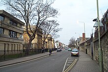
Walton Street is on the eastern edge of the Jericho district of central Oxford, England. [1]
Walton Street is on the eastern edge of the Jericho district of central Oxford, England. [1]
The street runs north from the western end of Beaumont Street and the northern end of Worcester Street by the main entrance of Worcester College. The Clarendon Institute building, which houses the Oxford Centre for Hebrew and Jewish Studies, is on the east side of the street. Somerville College, one of the former women-only colleges, also backs onto the street. The Oxford University Press (just south of the junction with Great Clarendon Street) and the original location of Ruskin College are on the west side of the street, the former Church of England parish church of Saint Paul on the east side is almost opposite the OUP and St Sepulchre's Cemetery is off the street to the west.
The Oxford University Press is a neoclassical building erected 1826–30. [2] The central part was designed by Daniel Robertson and the north and west wings by Edward Blore. [2] Modern extensions were added in 1960–61 and early in the 1970s. [2]
The Freud café-bar stands opposite the Oxford University Press, and at the head of Great Clarendon Street. The bar, which was opened in 1988, is housed in a grand neoclassical building with an Ionic portico. [3] This building was constructed as the Church of St Paul, the first Anglican parish church to be constructed in Oxford after the Reformation. [4] The new church and parish was created to serve the growing community of Jericho. The building was designed by the architect H. J. Underwood and built in 1836. [3] The architect E. G. Bruton added the apse in 1853 and F. C. Eden remodelled the interior in 1908. [3] In the 20th century St Paul's became a redundant church and, after deconsecration, became a theatre and arts centre. In 1988 the building was acquired by Secession Ltd. to prevent its demolition and opened as Freud café-bar. [5]
The Jericho Tavern is a public house and music venue at 56 Walton Street. In the late 1980s and early 1990s it was an important part of the music scene in Oxford, spawning the groups Ride, Radiohead [6] and Supergrass. [7]
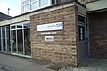
The central part of Walton Street has changed significantly as more areas are developed by the University of Oxford. The former Radcliffe Infirmary site on the east side will become the Radcliffe Observatory Quarter, a large campus for humanities research and administration. The long wall separating the Infirmary from the street has been punctuated by a new pedestrian route to Woodstock Road and a health centre.
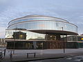
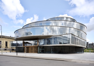
In 2015, a new controversial building [8] for the Blavatnik School of Government of Oxford University on the Radcliffe Observatory Quarter site, designed by Herzog & de Meuron, was opened immediately opposite the Oxford University Press building, dominating the location with its height (taller than Carfax Tower), and resulting in further removal of the high stone wall behind the old Infirmary site. [9] Exeter College has developed the former Ruskin College site opposite to the south for college accommodation as its Cohen Quad.
Little Clarendon Street, a shopping street, links Walton Street with Saint Giles. There are numerous restaurants on Walton Street, often used by Oxford University students because of its central position, such as Branca, Loch Fyne, The Jericho Cafe, Arzoo, Brasserie Blanc (associated with the chef Raymond Blanc) [10] and The Standard Tandoori. Oxford's main independent art house cinema, the Phoenix Picturehouse, is on the west side of the street. [11] A number of cocktail bars and pubs can be found on Walton Street.
Other shops include the speciality florist Daisies [12] and Branca Delicatessen.
Northwards the street continues as Kingston Road through Walton Manor, at a junction with Walton Well Road to the northwest towards Port Meadow and St Bernard's Road to the east, linking with Woodstock Road. Near the northern end of Walton Street, Observatory Street also links Woodstock Road to the east.


Somerville College, a constituent college of the University of Oxford in England, was founded in 1879 as Somerville Hall, one of its first two women's colleges. Among its alumnae have been Margaret Thatcher, Indira Gandhi, Dorothy Hodgkin, Iris Murdoch, Vera Brittain and Dorothy L. Sayers. It began admitting men in 1994. Its library is one of Oxford's largest college libraries. The college's liberal tone derives from its founding by social liberals, as Oxford's first non-denominational college for women, unlike the Anglican Lady Margaret Hall, the other to open that year. In 1964, it was among the first to cease locking up at night to stop students staying out late. No gowns are worn at formal halls.

Little Clarendon Street is a short shopping street in northwest Oxford, England. It runs east-west between the south end of Woodstock Road opposite St Giles' Church to the east, Somerville College to the north and Walton Street to the west. One of the three principal streets in North Oxford off the Woodstock Road, the shops and cafés located there are considered bohemian; the other two streets are North Parade and South Parade. Occasionally nicknamed Little Trendy Street, its reputation was already apparent in the 1960s.

Jericho is an historic suburb of the English city of Oxford. It consists of the streets bounded by the Oxford Canal, Worcester College, Walton Street and Walton Well Road. Located outside the old city wall, it was originally a place for travellers to rest if they had reached the city after the gates had closed. The name Jericho may have been adopted to signify this 'remote place' outside the wall. As of February 2021, the population of Jericho and Osney wards was 6,995.

North Oxford is a suburban part of the city of Oxford in England. It was owned for many centuries largely by St John's College, Oxford and many of the area's Victorian houses were initially sold on leasehold by the college.

The High Street in Oxford, England, known locally as the High, runs between Carfax, generally seen as the centre of the city, and Magdalen Bridge to the east.

Woodstock Road is a major road in Oxford, England, running from St Giles' in the south, north towards Woodstock through the leafy suburb of North Oxford. To the east is Banbury Road, which it meets at the junction with St Giles'.

Parks Road is a road in Oxford, England, with several Oxford University colleges along its route. It runs north–south from the Banbury Road and Norham Gardens at the northern end, where it continues into Bradmore Road, to the junction with Broad Street, Holywell Street and Catte Street to the south.

The Radcliffe Infirmary was a hospital in central north Oxford, England, located at the southern end of Woodstock Road on the western side, backing onto Walton Street.

The Oxford University Science Area in Oxford, England, is where most of the science departments at the University of Oxford are located.
Walton Manor is a residential suburb in Oxford, England. It is north of Jericho and the Radcliffe Observatory Quarter and forms part of North Oxford. The street layout and many of the area's buildings date from the mid-19th century. It was developed on land belonging to St John's College, Oxford.

Green Templeton College (GTC) is a constituent college of the University of Oxford in the United Kingdom. The college is located on the former Green College site on Woodstock Road next to the Radcliffe Observatory Quarter in North Oxford and is centred on the architecturally important Radcliffe Observatory, an 18th-century building, modelled on the ancient Tower of the Winds at Athens. It is the university's second newest graduate college, after Reuben College, having been founded by the historic merger of Green College and Templeton College in 2008.

Jericho Health Centre is a health centre on Walton Street in Oxford, England. It is named after the district of Jericho, just northwest of central Oxford. It is part of the United Kingdom's National Health Service (NHS).

Observatory Street is a street in Oxford, England. It links at the eastern end Woodstock Road in central North Oxford and at the western end Walton Street and the Jericho area of Oxford, England.

The Radcliffe Observatory Quarter (ROQ) is a major University of Oxford development project in Oxford, England, in the estate of the old Radcliffe Infirmary hospital. The site, covering 10 acres is in central north Oxford. It is bounded by Observatory Street and Green Templeton College to the north, the Woodstock Road to the east, Somerville College to the south, and Walton Street to the west. The project and the new university area is named after the grade I listed Radcliffe Observatory to the north east of the site, now the centrepiece of Green Templeton College, which is intended to form the visual centrepiece of the project.
The Blavatnik School of Government is a school of public policy founded in 2010 at the University of Oxford in England. The School was founded following a £75 million donation from a business magnate Len Blavatnik, supported by £26 million from the University of Oxford. It is part of Oxford's Social Sciences Division, which aims to train current and future leaders in the practice of government.
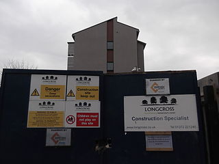
Longcross was a British construction company which entered into administration in June 2015. The head office was based in Ashtead, Surrey, England.

Freud is a café-bar in a Victorian former church building at 119 Walton Street in Jericho, Oxford, England.

The following is a timeline of the history of the city, university and colleges of Oxford, England.

Great Clarendon Street is one of the principal thoroughfares of the Jericho district of Oxford, England, an inner suburb northwest of the centre of the city.
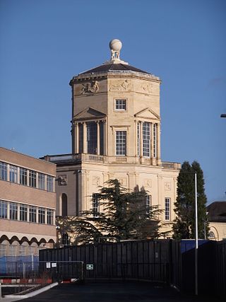
The Tower of the Winds is the prominent octagonal tower on top of the old Radcliffe Observatory building in Oxford, England. The building now forms a centrepiece for Green Templeton College, one of the colleges of Oxford University.
{{cite book}}: CS1 maint: multiple names: authors list (link)