Wareham Castle and town defences

Last updated
Wareham Castle and town defences
Dorset, England
Wareham Town Wall, west - geograph.org.uk - 762804.jpg
Western part of the walls
Dorset UK location map.svg
Red pog.svg
Wareham Castle and town defences
Coordinates 50°41′03″N2°06′44″W / 50.68422°N 2.11218°W / 50.68422; -2.11218 Coordinates: 50°41′03″N2°06′44″W / 50.68422°N 2.11218°W / 50.68422; -2.11218
Grid reference grid reference SY921871
Site information
OwnerPrivate and town council
ConditionEarthworks remain
Site history
MaterialsStone, timber and earth
Battles/wars English Civil War

Wareham Castle and the town defences, known locally as the Walls, were fortifications in the town of Wareham in Dorset, England.

Contents

1st-11th century

The site of the town of Wareham was probably occupied in the pre-Roman period and a Roman settlement was established there, taking advantage of its strategic location along the River Frome. [1] It was taken by the Saxons in the late 6th century and, by the end of the 9th century, it had become one of the most important Anglo-Saxon burhs in Dorset. [2] The burhs were defensive sites created by King Alfred the Great and his son Edward the Elder to defend the borders of the kingdom of Wessex, although the work at Wareham may potentially have built on existing defences. [3]

The defences encompassed a rectangular area, up to 90 acres (36 ha) in size. [4] It took the form of an earthwork bank with a protective ditch, topped by timber-faced ramparts, approximately 585 yards (535 m) long on the west side, 670 yards (610 m) along the north and 760 yards (690 m) on the eastern side – the length of the southern edge along the river is unknown. [5] Four entrances to the town were built, one on each side. [6] Probably at the end of the 10th century, or the beginning of the 11th century, the timber facings were replaced with stone. [7] A system of taxes was established to support the burhs and in the Burghal Hidage record that survives from the reign of Edward, it shows that 1,600 hides – an area of land – were allocated for Wareham, sufficient to maintain 2,200 yards of ramparts. [8]

12th-16th centuries

Wareham Castle was built in the south-west corner of the old Anglo-Saxon earthworks, taking the form of a motte with an inner and outer bailey, protected with timber defences and a ditch. [9] The original size of the motte is not known; 18th- and 19th-century records suggest it was between 55 and 60 feet (17–18 m) across. [10] It is uncertain when the castle was built; it may have been constructed soon after the Norman Conquest in 1066, although no physical evidence has been found to prove this theory. [11] If the castle was built soon after 1066, the construction work may have required the extensive demolition of houses in that part of the town, and the decision to place it in the south-west sector may have been linked to the presence of a former Anglo-Saxon royal residence there. [12]

Robert Beaumont controlled the castle in 1118, when he passed it onto Robert, Earl of Gloucester, who carried out work on it in 1137. [13] A small, square keep 37 feet (11 m) across with pilaster buttresses at the corners, was built from stone rubble on the top of the motte, probably at the beginning of the 12th century. [14] The bailey was protected by a stone curtain wall, known to have been 5 feet (1.5 m) thick in places. [15] During the civil conflict known as The Anarchy in the 1140s, Wareham Castle lay on the border between the territories of the rival claimants for the throne, King Stephen and the Empress Matilda, and was the location of the regional mint. [16] Robert was a supporter of Matilda, and the castle exchanged hands between him and Stephen several times in the next few years, with the town being possibly burnt by Stephen. [17] By the end of the fighting, nearby Corfe Castle had taken over as the most important military fortification in the region. [18]

After 1154 and the end of the civil war, the castle was controlled by the earls of Gloucester. [19] The town's economy stagnated during the late 12th and 13th centuries, although in 1207 the castle, which had been confiscated by King John, was repaired and used by the monarch as a stopping point on the way to Corfe Castle. [20] After John, Wareham passed to the Earls of Clare, who paid it little attention, and the outer bailey ditch was filled in early in the 13th century. [21] The river silted up and the port declined in importance, with trade focusing on Poole instead; by the 14th century, the town was in economic decline. [22]

17th-21st centuries

Depiction of the surviving castle and walls in 1888; red-dotted line shows the line of the castle's inner and outer baileys Wareham Castle and town defences - G. T. Clark.png
Depiction of the surviving castle and walls in 1888; red-dotted line shows the line of the castle's inner and outer baileys

During the English Civil War of the 1640s, Wareham initially supported Parliament, and £60 was spent in 1642 improving the town walls. [23] The Royalists, under Ralph Hopton, 1st Baron Hopton, took the town in 1643, but Parliament retook it in 1644, when soldiers led by Sir Ashley Cooper forced their way through the West Gate in the walls. [24] The town wall was reinforced during the conflict, possibly with circular platforms positioned at key points. [25] Parliament was advised that the defences remained useful and that they were too substantial to be slighted – deliberately damaged to put them beyond use. [26] In 1685, seven men were executed for their part in the Monmouth Rebellion on the west bank of the defences, the section of which now carries the name of the "Bloody Bank". [27]

It is not known when the castle was finally abandoned, but by the 18th century, buildings were encroaching on the eastern edge of the castle site, with the remainder forming an open area, known as Castle Green. [28] During the early 19th century, houses began to be built around the base of the motte, which was then enclosed in the late-19th century, with a villa called Castle Close was built on top of the motte in 1911. [29] This required extensive changes to the shape of the motte, which is now 250 feet (76 m) in diameter, and 120 feet (37 m) across at the top. [30] Most of the castle ditch was filled in, with the remaining elements 70 feet (21 m) across and 22 feet (6.7 m) deep. [31] The foundations of the keep still survive within the motte, and the lines of the inner and outer bailey are traced by the Pound and Trinity lanes. [32]

It is not known when the stone from the Anglo-Saxon defences was removed. [33] Around 1850, a road was cut through part of the western town wall, and further alterations were made in 1940 during the Second World War to protect it against potential attacks by enemy tanks. [34] In 1956, the town authorities took over management and conservation of the remaining walls. [35] The Anglo-Saxon defences remain up to 55 feet (17 m) across and 17 feet (5.2 m) high in places, although the southern line along the river have been lost and only minimal parts of the eastern side remain; the south-eastern corner was destroyed at some point before the 18th century. [36]

Early investigations into the Anglo-Saxon defences were undertaken in 1910, 1930 and 1951, and more substantial excavations were carried out on the Anglo-Saxon defence between 1952 and 1954. [37] The remains of the castle and the town defences are protected under UK law as a scheduled monument. [38]

See also

Related Research Articles

Cardiff Castle Grade I listed castle in Cardiff, Wales

Cardiff Castle is a medieval castle and Victorian Gothic revival mansion located in the city centre of Cardiff, Wales. The original motte and bailey castle was built in the late 11th century by Norman invaders on top of a 3rd-century Roman fort. The castle was commissioned either by William the Conqueror or by Robert Fitzhamon, and formed the heart of the medieval town of Cardiff and the Marcher Lord territory of Glamorgan. In the 12th century the castle began to be rebuilt in stone, probably by Robert of Gloucester, with a shell keep and substantial defensive walls being erected. Further work was conducted by the 6th Earl of Gloucester in the second half of the 13th century. Cardiff Castle was repeatedly involved in the conflicts between the Anglo-Normans and the Welsh, being attacked several times in the 12th century, and stormed in 1404 during the revolt of Owain Glyndŵr.

Tamworth Castle Norman castle in Tamworth, Staffordshire, England

Tamworth Castle, a Grade I listed building, is a Norman castle overlooking the mouth of the River Anker into the Tame in the town of Tamworth in Staffordshire, England. Before boundary changes in 1889, however, the castle was within the edge of Warwickshire while most of the town belonged to Staffordshire.

Wareham, Dorset Human settlement in England

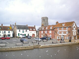
Wareham is a historic market town and, under the name Wareham Town, a civil parish, in the English county of Dorset. The town is situated on the River Frome eight miles (13 km) southwest of Poole.

Wing, Buckinghamshire Human settlement in England

Wing, known in antiquated times as Wyng, is a village and civil parish in east Buckinghamshire, England. The village is on the main A418 road between Aylesbury and Leighton Buzzard. It is about 8 miles (13 km) north-east of Aylesbury, 3 miles (5 km) west of Leighton Buzzard, and 12 miles (19 km) south of Milton Keynes.

Oxford Castle Partly ruined castle in Oxford in Oxfordshire, England

Oxford Castle is a large, partly ruined Norman medieval castle on the western side of central Oxford in Oxfordshire, England. Most of the original moated, wooden motte and bailey castle was replaced in stone in the late 12th or early 13th century and the castle played an important role in the conflict of the Anarchy. In the 14th century the military value of the castle diminished and the site became used primarily for county administration and as a prison. The surviving rectangular St George's Tower is now believed to pre-date the remainder of the castle and be a watch tower associated with the original Saxon west gate of the city.

Hodnet Human settlement in England

Hodnet is a village and civil parish in Shropshire, England. The town of Market Drayton lies 5.7 miles (9.2 km) north-east of the village.

Wallingford Castle Castle in Wallingford, Oxfordshire, UK

Wallingford Castle was a major medieval castle situated in Wallingford in the English county of Oxfordshire, adjacent to the River Thames. Established in the 11th century as a motte-and-bailey design within an Anglo-Saxon burgh, it grew to become what historian Nicholas Brooks has described as "one of the most powerful royal castles of the 12th and 13th centuries". Held for the Empress Matilda during the civil war years of the Anarchy, it survived multiple sieges and was never taken. Over the next two centuries it became a luxurious castle, used by royalty and their immediate family. After being abandoned as a royal residence by Henry VIII, the castle fell into decline. Refortified during the English Civil War, it was eventually slighted, i.e. deliberately destroyed, after being captured by Parliamentary forces after a long siege. The site was subsequently left relatively undeveloped, and the limited remains of the castle walls and the considerable earthworks are now open to the public.

English Bicknor Human settlement in England

English Bicknor is a village and civil parish in the Forest of Dean district of west Gloucestershire, England. The 2011 Census recorded the population as 408. The village is near the county boundary with Herefordshire, opposite which is the village of Welsh Bicknor. The two villages are on opposite sides of the River Wye.

Clare Castle Castle in Suffolk, England

Clare Castle is a high-mounted ruinous medieval castle in the parish and former manor of Clare in Suffolk, England, anciently the caput of a feudal barony. It was built shortly after the Norman Conquest of England in 1066 by Richard Fitz Gilbert, having high motte and bailey and later improved in stone. In the 14th century it was the seat of Elizabeth de Clare, one of the wealthiest women in England, who maintained a substantial household there. The castle passed into the hands of the Crown and by 1600 was disused. The ruins are an unusually tall earthen motte surmounted by tall remnants of a wall and of the round tower, with large grassland or near-rubble gaps on several of their sides. It was damaged by an alternate line of the Great Eastern Railway in 1867, the rails of which have been removed.

Christchurch Castle

Christchurch Castle is located in Christchurch, Dorset, England. The earliest stonework has been dated to 1160. It is a Norman motte and bailey castle. The castle's site is inside the old Saxon burh dominating the River Avon's lowest crossing.

Hough-on-the-Hill Village and civil parish in the South Kesteven district of Lincolnshire, England

Hough-on-the-Hill is a village and civil parish in the South Kesteven district of Lincolnshire, England. The population of the civil parish including Brandon was 399 at the 2011 census. It is situated approximately 7 miles (11 km) due north from the market town of Grantham. The hamlets of Gelston and Brandon are part of the parish. Hough-on-the-Hill is on a significant rise, hence the name.

Deddington Castle Motte-and-bailey castle in Oxfordshire

Deddington Castle is an extensive earthwork in the village of Deddington, Oxfordshire, all that remains of an 11th-century motte-and-bailey castle, with only the earth ramparts and mound now visible.

Driffield Castle is located in the town of Driffield, approximately 12 miles (19 km) north of Beverley, East Riding of Yorkshire, England.

Taunton Castle

Taunton Castle is a castle built to defend the town of Taunton, Somerset, England. It has origins in the Anglo Saxon period and was later the site of a priory. The Normans then built a stone structured castle, which belonged to the Bishops of Winchester. The current heavily reconstructed buildings are the inner ward, which now houses the Museum of Somerset and the Somerset Military Museum. The building was designated a grade I listed building in 1952.

Corfe Castle 11th-century castle in Dorset, England

Corfe Castle is a fortification standing above the village of the same name on the Isle of Purbeck peninsula in the English county of Dorset. Built by William the Conqueror, the castle dates to the 11th century and commands a gap in the Purbeck Hills on the route between Wareham and Swanage. The first phase was one of the earliest castles in England to be built at least partly using stone when the majority were built with earth and timber. Corfe Castle underwent major structural changes in the 12th and 13th centuries.

Berkhamsted Castle Norman castle in Berkhamsted, Hertfordshire

Berkhamsted Castle is a Norman motte-and-bailey castle in Berkhamsted, Hertfordshire. The castle was built to obtain control of a key route between London and the Midlands during the Norman conquest of England in the 11th century. Robert of Mortain, William the Conqueror's half brother, was probably responsible for managing its construction, after which he became the castle's owner. The castle was surrounded by protective earthworks and a deer park for hunting. The castle became a new administrative centre of the former Anglo-Saxon settlement of Berkhamsted. Subsequent kings granted the castle to their chancellors. The castle was substantially expanded in the mid-12th century, probably by Thomas Becket.

St Martins Church, Wareham Church in United Kingdom

St Martin's Church, Wareham, sometimes St Martin's-on-the-walls, is an Anglo-Saxon church in the town of Wareham, Dorset in England. It is the most complete example of an Anglo-Saxon church in Dorset.

Lady St Mary Church, Wareham Church in United Kingdom

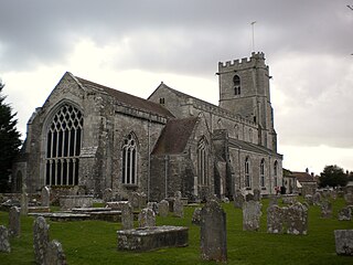
The parish church of Lady St. Mary, Wareham is a church of Anglo-Saxon origin in the town of Wareham, Dorset, in England. The church is notable as the possible burial place of King Beorhtric, and for the discovery of five stones with Brittonic inscriptions dating to the 7th to 9th centuries. A notable feature is the unique hexagonal lead font dating to around 1200. The Anglo-Saxon nave was demolished in 1842.

Scheduled monuments in Somerset Nationally important sites in Somerset, England

There are over 670 scheduled monuments in the ceremonial county of Somerset in South West England. The county consists of a non-metropolitan county, administered by Somerset County Council, which is divided into five districts, and two unitary authorities. The districts of Somerset are West Somerset, South Somerset, Taunton Deane, Mendip and Sedgemoor. The two administratively independent unitary authorities, which were established on 1 April 1996 following the breakup of the county of Avon, are North Somerset and Bath and North East Somerset. These unitary authorities include areas that were once part of Somerset before the creation of Avon in 1974.

References

  1. Royal Commission on the Historical Monuments of England 1959 , pp. 120–121
  2. Royal Commission on the Historical Monuments of England 1959 , p. 122
  3. Royal Commission on the Historical Monuments of England 1959 , pp. 122–123
  4. Royal Commission on the Historical Monuments of England 1959 , pp. 120–121
  5. Royal Commission on the Historical Monuments of England 1959 , p. 137; Royal Commission on the Historical Monuments of England (1970), "Wareham Lady St. Mary", British History Online, retrieved 26 August 2016
  6. "Part of the Defences of the Anglo-Saxon Fortified Centre of Wareham and Part of the Motte and Bailey Castle with Shell Keep", Historic England, retrieved 26 August 2016
  7. Royal Commission on the Historical Monuments of England 1959 , p. 137
  8. "Part of the Defences of the Anglo-Saxon Fortified Centre of Wareham and Part of the Motte and Bailey Castle with Shell Keep", Historic England, retrieved 26 August 2016; Royal Commission on the Historical Monuments of England (1970), "Wareham Lady St. Mary", British History Online, retrieved 26 August 2016
  9. Royal Commission on the Historical Monuments of England (1970), "Wareham Lady St. Mary", British History Online, retrieved 26 August 2016; Dorset County Council 2011 , pp. 29, 34
  10. Royal Commission on the Historical Monuments of England (1970), "Wareham Lady St. Mary", British History Online, retrieved 26 August 2016; Mackenzie 1896 , p. 253
  11. Dorset County Council 2011 , p. 31; Royal Commission on the Historical Monuments of England (1970), "Wareham Lady St. Mary", British History Online, retrieved 26 August 2016
  12. Dorset County Council 2011 , p. 29
  13. Dorset County Council 2011 , pp. 29, 31
  14. Dorset County Council 2011 , p. 31; Royal Commission on the Historical Monuments of England (1970), "Wareham Lady St. Mary", British History Online, retrieved 26 August 2016
  15. Royal Commission on the Historical Monuments of England (1970), "Wareham Lady St. Mary", British History Online, retrieved 26 August 2016
  16. Dorset County Council 2011 , p. 29
  17. Dorset County Council 2011 , p. 29
  18. Dorset County Council 2011 , p. 29
  19. "Part of the Defences of the Anglo-Saxon Fortified Centre of Wareham and Part of the Motte and Bailey Castle with Shell Keep", Historic England, retrieved 26 August 2016
  20. Dorset County Council 2011 , p. 33; "Part of the Defences of the Anglo-Saxon Fortified Centre of Wareham and Part of the Motte and Bailey Castle with Shell Keep", Historic England, retrieved 26 August 2016
  21. Dorset County Council 2011 , pp. 33, 36
  22. Dorset County Council 2011 , p. 33
  23. Dorset County Council 2011 , p. 37; Royal Commission on the Historical Monuments of England 1959 , p. 123
  24. Royal Commission on the Historical Monuments of England 1959 , p. 123; Dorset County Council 2011 , p. 37; Mackenzie 1896 , p. 255
  25. Dorset County Council 2011 , p. 37
  26. Royal Commission on the Historical Monuments of England 1959 , p. 123
  27. Dorset County Council 2011 , p. 40; Mackenzie 1896 , p. 255
  28. Dorset County Council 2011 , pp. 39, 41; Royal Commission on the Historical Monuments of England (1970), "Wareham Lady St. Mary", British History Online, retrieved 26 August 2016
  29. Dorset County Council 2011 , p. 45
  30. Royal Commission on the Historical Monuments of England (1970), "Wareham Lady St. Mary", British History Online, retrieved 26 August 2016
  31. Dorset County Council 2011 , p. 34; Royal Commission on the Historical Monuments of England (1970), "Wareham Lady St. Mary", British History Online, retrieved 26 August 2016
  32. Dorset County Council 2011 , p. 34; Royal Commission on the Historical Monuments of England (1970), "Wareham Lady St. Mary", British History Online, retrieved 26 August 2016
  33. Royal Commission on the Historical Monuments of England 1959 , p. 137
  34. Royal Commission on the Historical Monuments of England 1959 , pp. 124, 137
  35. Dorset County Council 2011 , p. 53
  36. Royal Commission on the Historical Monuments of England 1959 , pp. 120–121; Dorset County Council 2011 , p. 40
  37. Royal Commission on the Historical Monuments of England 1959 , pp. 120, 124
  38. "Part of the Defences of the Anglo-Saxon Fortified Centre of Wareham and Part of the Motte and Bailey Castle with Shell Keep", Historic England, retrieved 26 August 2016

Bibliography