Wari Empire

Last updated
Wari Empire
6th century–11th century
Map of Wari and Tiawaku.svg
Expansion and area of cultural influence.
Capital Huari
Common languages Aymara, others.
Religion
Staff God
Historical era Middle Horizon
 Established
6th century
 Disestablished
11th century
Preceded by
Succeeded by
Map of Wari in Peru.svg Wari culture
Mapa de expansion de Wari y Tiwanaku (Estados Pre-Incas).jpg Tiwanaku Empire
Kingdom of Cusco Kigdomofcuscomap.JPG
Chimor Mapa Chimor.svg
Aymara kingdoms Banner of the Qulla Suyu.svg
Today part of Peru

The Wari Empire or Huari Empire was a political formation that emerged around 600 AD (CE) in Peru's Ayacucho Basin and grew to cover much of coastal and highland Peru. [1] The empire lasted for about 500 years, until 1100 CE. [2] It existed during the same era as the Tiwanaku culture, and at one time, was thought to have been derived from it. [3] In 2008, archeologists found a precolumbian city, the Northern Wari ruins (also called Cerro Pátapo) near modern Chiclayo. [4] The find was the first extensive settlement related to the Wari culture discovered that far north. [5] [6] Archaeological discoveries have continued over the past decade. In 2023, archaeologists discovered a 1200-year-old Wari ritual complex in Arequipa. [7] While more discoveries are being made regarding the Wari Empire, archaeologists are able to draw more conclusions about the Wari Empire's culture.

Contents

Political relations

The Wari Empire was a second-generation state of the Andean region; both it and Tiwanaku had been preceded by the first-generation Moche state. When expanding to engulf new polities, the Wari Empire practiced a policy of allowing the local leaders of the newly acquired territory to retain control of their area if they agreed to join the Wari empire and obey the Wari.

The political relationship between the Wari and Tiwanaku has been compared by archaeologist Joyce Marcus to that of the United States and the Soviet Union during the Cold War: the two empires did not go to war with one another for fear of mutual destruction. The two empires met at Moquegua, where the Wari and Tiwanaku populations co-existed without conflicts. [8]

Administration

While the Wari likely had significant organizational and administrative power, it remains unclear what the origins of its political and artistic forms were. Emerging evidence suggests that rather than being the result of Tiwanaku traits diffusing north, the Wari and Tiwanaku ideological formations may be traceable to previous developments at Pukara, an Early Intermediate Period culture to the north of Lake Titicaca. [8] The polity seems to have survived until ca. AD 1100, when it collapsed, likely as a result of both environmental change and internal socio-political stresses.

The expanding state likely had a fairly symbiotic relationship with local people. The colonizers would likely trade, intermarry, feast, partake in religious rituals, or just directly coerce local residents [9] . There was also likely a wide variety of impacts from community to community, some were largely impacted by the state and others less so, depending on location and time [9] . Contact with the larger empire could have been beneficial for smaller communities because they were able to establish trade and obtain exotic goods not previously available to them. [9]

One of the commodities was beer, communal consumption of beer served as a potent instrument of Wari governance. [10] Forging hierarchical ties within, and between groups, was often a prevalent theme in Wari feasting. At Quilcapampa, guests partaking in Wari-related feasts were served alcohol infused with vilca. The vilca-infused brew fostered collective, psychotropic, experiences. The providers of the brew, Wari leaders, reinforced their elevated status within the social hierarchy. The presence of alcoholic beverages, evidenced by the abundance of maize and molle at Wari sites, indicates their widespread consumption during feasts. [11]

The empire established long-distance exchange networks to obtain hallucinogens. [12] To connect the highland capital and Pacific coast, the Wari constructed an imperial highway. Going through the Sondondo Valley, the highway connected three imperial sites.

With the tremendous amount of effort required to obtain the drug, it hints that vilca was an important part of the Wari political economy.

Infrastructure

Scholars, such as William Isbell, Katherine Schreiber and Luis Lumbreras consider the Wari an Empire largely due to their infrastructure. They note its construction of an extensive network of roadways linking provincial cities, as well as the construction of complex, characteristic architecture in its major centres, some of which were quite extensive. Leaders had to plan projects and organize large amounts of labor to accomplish such projects. [13] [14] At the Wari colony, Pikillacta, irrigation canals and terraces were built. The irrigation canals and terraces served to moved water throughout the colony, allowing the colony to utilize agriculture. [15]

War, Conflict, and Imperialism

The Wari had an expansionist culture beginning sometime in the seventh century AD, [16] given its military related weaponry. It is estimated that their expansionist nature led to a greater level of violence than many of the other pre-Hispanic cultures. [17] It's speculated that the Wari relied on force to conquer and consolidate territories, [18] utilizing of cost-effective strategies. Those may have ranged from implied force, coercive diplomacy, to co-opting local political hierarchies. [19]

Militarism played a significant role in the Wari Empire, evident in various aspects of its structure and iconography. Subsidiary centers surrounding the capital were fortified, indicating a strategic emphasis on defense. [20] A 2-square-kilometer walled complex at Pikillaqta potentially housed a military garrison, fortified with smaller sites and walls designed to resist military threats and control access. [21] Wari iconography frequently depicts soldiers equipped with military weaponry suggesting readiness for violent conflict. [22]

By building imperial-style infrastructure, the empire-controlled areas along the Pacific coast and Andean highlands. Provincial centers include Viracochapampa, Honcopampa, and Cerro Baúl, all of which share similar architectural styles and ceramic vessels. [16] These sites were connected to the capital, Huari, by a network of imperial roads creating a unified polity.

At the World Congress on Mummy Studies, research shed light on the collapse of the Wari Empire, where Wari society transitioned from cooperation to violence. Tiffiny Tung, a bioarchaeologist of Vanderbilt University, showcased a study highlighting the connections seen between environmental stressors, political instability, and societal collapse in the empire's collapse. [2] Following 1000 C.E. was a period marked by violence and hardship following the empire's demise. The collapse, possibly exacerbated by severe drought, unleashed centuries of violence and social breakdown, leaving a vivid record in human bones.

Cerro Baul- an important Wari administrative and ceremonial center. Located in the highlands of Peru. Cerro Baul, Torata, Moquegua, Peru - panoramio.jpg
Cerro Baúl- an important Wari administrative and ceremonial center. Located in the highlands of Peru.

Through analysis of skeletal remains from Huari, violence seemed to be present even during the empire's peak, intensifying afterward, seen by a dramatic increase in fatal injuries. The collapse also affected dietary patterns, with women experiencing significant changes, possibly indicating food scarcity or dietary shifts. Moreover, post-collapse burials showed signs of desecration, suggesting a shift in traditional burial practices and social norms. Ongoing research seeks to uncover molecular indicators of stress in ancient DNA, providing further insights into the health and well-being of Wari society during this period. [2]

Archaeological Sites

Huari- Tomb containing remains in the capital city of the Wari empire Tomb at Wari ruins near Ayacucho.jpg
Huari- Tomb containing remains in the capital city of the Wari empire

Northern Wari Ruins (Cerro Pátapo)

Pikillacta- Large Wari architectural site 20 miles east of Cusco Piquillacta Archaeological site - street.jpg
Pikillacta- Large Wari architectural site 20 miles east of Cusco

In 2008, a team led by archaeologist, Cesar Soriano discovered the ruins of a city near Chiclayo. The Northern Wari Ruins provide the first evidence of the Wari in Northern Peru. [5] There are signs of human sacrifice in the site as Archaeologists have found bones at the bottom of a cliff. Along with the piles of bones, the remains of a young women were found. [5] [6] Evidence found by archaeologists at the site suggests a potential link between the Wari and Moche Civilization. The site has been preserved well due to the hot dry climate of Peru. [23]

Pikillacta (Pikillaqta)

Pikillacta was a 495 acre settlement near the Cusco basin. [15] The central part of Pikillacta was a series of multi-room buildings that Joyce Marcus compared to ice trays. [15] The first archaeological excavation of Pikillacta was conducted in 1927 but minimal evidence was found. [24] Through three separate excavations, Gordon McEwan made extensive discoveries at Pikillacta. Although Pikillacta is one of the largest Wari Archaeological sites that has been found, there is not a substantial amount of evidence suggesting that people actually lived there. [21] Evidence found at the suite, such as the lack of doorways, has led archaeologists to theorize that Pikillacta could have been used as an insane asylum or prison. [21]

Related Research Articles

<span class="mw-page-title-main">Tiwanaku</span> Archaeological site in Bolivia

Tiwanaku is a Pre-Columbian archaeological site in western Bolivia, near Lake Titicaca, about 70 kilometers from La Paz, and it is one of the largest sites in South America. Surface remains currently cover around 4 square kilometers and include decorated ceramics, monumental structures, and megalithic blocks. In AD 800 the site has been conservatively estimated to have been inhabited by 10,000 to 20,000 people.

<span class="mw-page-title-main">Staff God</span> Religious icon in the Andes

In "Southern Andean Iconographic Series" the Staff God pose is a religious icon and a standardized pose reminiscent in its way of the standardized poses in Byzantine art. The pose shows a front-facing human or human-like figure with vertical attributes, one in each hand. There is no uniform representation of a "Staff God". Dozens of variations of "Staff Gods" exist. Some scholars think that some of these personages are possible depictions of Viracocha or Thunupa. However, there is little evidence to support the idea that these front-facing figures do represent deities. Some researchers point to their attributes and spatial organization which seem to indicate that they are ritual practitioners. Some attributes in their hands were identified as Qirus, Snuff trays and Spear-throwers. The "rays" radiating or sprouting out of the faces of Tiwanaku front-facing figures appear to have approximately the value of an aureole. They may represent flows and distribution of energy. At the Wari site of Conchopata a vessel was found which shows a Staff God in which the "rays" can be interpreted as a Anadenanthera colubrina tree sprouting from its head whereas the circular elements do represent its seed pods.

<span class="mw-page-title-main">Wari culture</span> Pre-Inca Culture, c. 500 BCE–1000 CE

The Wari were a Middle Horizon civilization that flourished in the south-central Andes and coastal area of modern-day Peru, from about 500 to 1000 AD.

<span class="mw-page-title-main">Chachapoya culture</span> Andean culture

The Chachapoyas, also called the "Warriors of the Clouds", was a culture of the Andes living in the cloud forests of the southern part of the Department of Amazonas of present-day Peru. The Inca Empire conquered their civilization shortly before the Spanish conquest in the 16th century. At the time of the arrival of the conquistadors, the Chachapoyas were one of the many nations ruled by the Incas, although their incorporation had been difficult due to their constant resistance to Inca troops.

<span class="mw-page-title-main">Chimor</span> Political grouping of the Chimú culture in early Peru

Chimor was the political grouping of the Chimú culture. The culture arose about 900 CE, succeeding the Moche culture, and was later conquered by the Inca emperor Topa Inca Yupanqui around 1470, fifty years before the arrival of the Spanish in the region. Chimor was the largest kingdom in the Late Intermediate Period, encompassing 1,000 kilometres (620 mi) of coastline.

<span class="mw-page-title-main">Paracas culture</span> Archaeological culture of Peru

The Paracas culture was an Andean society existing between approximately 800 BCE and 100 BCE, with an extensive knowledge of irrigation and water management and that made significant contributions in the textile arts. It was located in what today is the Ica Region of Peru. Most information about the lives of the Paracas people comes from excavations at the large seaside Paracas site on the Paracas Peninsula, first formally investigated in the 1920s by Peruvian archaeologist Julio Tello.

<span class="mw-page-title-main">Chakana</span> Andean symbol

The Chakana is a stepped cross motif used by the Inca and pre-incan Andean societies. The most commonly used variation of this symbol today is made up of an equal-armed cross indicating the cardinal points of the compass and a superimposed square. Chakana means 'bridge', and means 'to cross over' in Quechua. The Andean cross motif appears in pre-contact artifacts such as textiles and ceramics from such cultures as the Chavín, Wari, Chancay, and Tiwanaku, but with no particular emphasis and no key or guide to a means of interpretation. The anthropologist Alan Kolata calls the Andean cross "one of the most ubiquitous, if least understood elements in Tiwanaku iconography". The Andean cross symbol has a long cultural tradition spanning 4,000 years up to the Inca Empire.

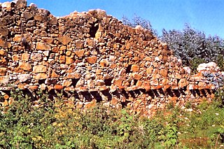
The Cerro Pátapo ruins or Northern Wari ruins are the remains of an entire precolumbian city relatively near the site of present-day Chiclayo, Peru. The ruins are primarily of the Wari (Huari) culture, which flourished from 350 CE to 1000 CE in the area along the coast and reaching to the highlands. These northern Wari ruins are distinguished from the Wari ruins in the Ayacucho Region to the south.

<span class="mw-page-title-main">Andean civilizations</span> Civilizations of South Americas Andes Mountains

The Andean civilizations were South American complex societies of many indigenous people. They stretched down the spine of the Andes for 4,000 km (2,500 mi) from southern Colombia, to Ecuador and Peru, including the deserts of coastal Peru, to north Chile and northwest Argentina. Archaeologists believe that Andean civilizations first developed on the narrow coastal plain of the Pacific Ocean. The Caral or Norte Chico civilization of coastal Peru is the oldest known civilization in the Americas, dating back to 3500 BCE. Andean civilization is one of the six "pristine" civilizations of the world, created independently and without influence by other civilizations.

<span class="mw-page-title-main">History of Andean South America</span>

The history of human habitation in the Andean region of South America stretches from circa 15,000 BCE to the present day. Stretching for 7,000 km (4,300 mi) long, the region encompasses mountainous, tropical and desert environments. This colonisation and habitation of the region has been affected by its unique geography and climate, leading to the development of unique cultural and socn.

<span class="mw-page-title-main">Viracochapampa</span> Archaeological site in Peru

Viracochapampa, Huiracochapampa, or Wiracochapampa is an archaeological site with the remains of a building complex of ancient Peru of pre-Inca times. It was one of the administrative centers of the Wari culture. Viracochapampa is located about 3.5 km north of Huamachuco in the region of La Libertad at an elevation of 3,070 metres (10,072 ft).

<span class="mw-page-title-main">Osmore River</span> River in Moquegua Region, Peru

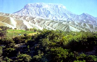
Osmore River system flows northeast to southwest in the Moquegua Region of southern coastal Peru. The river has its origin in the snow peaks of the Chuqi Ananta and Arundane mountains, at an elevation of 5,100 metres (16,700 ft) above sea level. It changes names as it descends from the Andes: From its origin it is called the Moquegua, then Osmore in the middle valley as Rio Coscori and Rio Tumilaca including where the river disappears into subterranean channels, and further down in the lower reaches as Rio Ilo.

<span class="mw-page-title-main">Tiwanaku Empire</span> Pre-Columbian polity in Western Bolivia

The Tiwanaku Polity was a Pre-Columbian polity in western Bolivia based in the southern Lake Titicaca Basin. Tiwanaku was one of the most significant Andean civilizations. Its influence extended into present-day Peru and Chile and lasted from around 600 to 1000 AD. Its capital was the monumental city of Tiwanaku, located at the center of the polity's core area in the southern Lake Titicaca Basin. This area has clear evidence for large-scale agricultural production on raised fields that probably supported the urban population of the capital. Researchers debate whether these fields were administered by a bureaucratic state (top-down) or through a federation of communities with local autonomy. Tiwanaku was once thought to be an expansive military empire, based mostly on comparisons to the later Inca Empire. However, recent research suggests that labelling Tiwanaku as an empire or even a state may be misleading. Tiwanaku is missing a number of features traditionally used to define archaic states and empires: there is no defensive architecture at any Tiwanaku site or changes in weapon technology, there are no princely burials or other evidence of a ruling dynasty or a formal social hierarchy, no evidence of state-maintained roads or outposts, and no markets.

Sonia Alconini Mujica is a Bolivian anthropologist and archaeologist specializing in the socioeconomic and political development of early states and empires in the Andes. She has studied the dynamics of ancient imperial frontiers, and the ways in which Guarani tropical tribes expanded over these spaces. She has also conducted work in the eastern Bolivian valleys and Lake Titicaca region.

<span class="mw-page-title-main">Cerro Baúl</span>

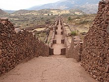
Cerro Baúl is an ancient political outpost and ceremonial center settlement in Peru established by the pre-Incan empire called the Wari. Cerro Baúl is a terraced mountain, 2000 feet above its surroundings, with a settlement on the cliff tops themselves and in the immediate surroundings. Among other finds are the remnants of a brewery and large buildings that may have been used for ceremonial feasting. There is evidence of damage that has been interpreted as a careful and deliberate destruction, by the city's own people, of several buildings prior to the mesa's being vacated.

<span class="mw-page-title-main">Chiribaya culture</span>

The Chiribaya culture flourished near the coast of southern Peru and adjacent Chile from 700 CE until Spanish settlement in the late 16th century. The classic phase of the Chiribaya culture was from 1000 CE until 1360 CE. The Chiribaya culture consisted of both maritime settlements along 220 kilometres (140 mi) of the Pacific Ocean coast and agricultural settlements inland in valleys of the Osmore and Tambo rivers in Peru and the Lluta river and Azapa Valley in Chile.

<span class="mw-page-title-main">Pre-Columbian Bolivia</span>

Pre-Columbian Bolivia covers the historical period between 10,000 BCE, when the Upper Andes region was first populated and 1532, when Spanish conquistadors invaded Inca empire. The Andes region of Pre-Columbian South America was dominated by the Tiwanaku civilization until about 1200, when the regional kingdoms of the Aymara emerged as the most powerful of the ethnic groups living in the densely populated region surrounding Lake Titicaca. Power struggles continued until 1450, when the Incas incorporated upper Bolivia into their growing empire. Based in present-day Peru, the Incas instituted agricultural and mining practices that rivaled those put in place many years later by European conquerors. They also established a strong military force, and centralized political power. Despite their best efforts however, the Incas never completely controlled the nomadic tribes of the Bolivian lowlands, nor did they fully assimilate the Aymara kingdoms into their society. These internal divisions doomed the Inca Empire when European conquerors arrived.

A snuff tray, also known as a snuff tablet, is a hand-carved tablet or tray that was made for the purpose of inhaling a psychoactive drug (also referred to as being hallucinogenic, entheogenic, or psychedelic, in the form similar to tobacco snuff prepared as a powder using a snuff tube. Snuff trays are best-known from the Tiwanaku culture of the Andes in South America. The principal substance thought to have been inhaled was known as willka, also referred to as cebil, and known as yopó in northern South America and cohoba in the Greater Antilles, where it was also prepared from other species of the genus Anadenanthera.

On the Cerro Baúl mesa, in the central highlands of Peru, elite women from the Wari Empire made a drink called chicha in the years before 600 AD.

References

  1. Schreiber, Katharina J. (April 1987). "Conquest and Consolidation: A Comparison of the Wari and Inka Occupations of a Highland Peruvian Valley". American Antiquity. 52 (2): 266–284. doi:10.2307/281780. ISSN   0002-7316. JSTOR   281780. S2CID   155131409.
  2. 1 2 3 Wade, Lizzie (August 17, 2016). "The Wari's grisly end—the fall of a South American empire". Science. Retrieved April 28, 2024.
  3. Williams, Patrick Ryan (2001). "Cerro Baúl: A Wari Center on the Tiwanaku Frontier". Latin American Antiquity. 12 (1): 67–83. doi:10.2307/971758. ISSN   1045-6635. JSTOR   971758.
  4. "Archaeologists unearth ancient Wari city". NBC News. 2008-12-17. Retrieved 2024-05-27.
  5. 1 2 3 "'Ancient city unearthed' in Peru". BBC. 17 December 2008. Retrieved 2008-12-17.
  6. 1 2 "Archeologists in Peru unearth ancient Wari city". Reuters. 16 December 2008. Retrieved 2008-12-17.
  7. Reid, David (March 2023). "The role of temple institutions in Wari imperial expansion at Pakaytambo, Peru". Journal of Anthropological Archaeology. 69. doi:10.1016/j.jaa.2023.101485 . Retrieved May 2, 2024.
  8. 1 2 Flannery, Kent; Marcus, Joyce (2012). The Creation of Inequality: How Our Prehistoric Ancestors Set the Stage for Monarchy, Slavery, and Empire. Harvard University Press. ISBN   978-0-674-06469-0. JSTOR   j.ctt2jbvjr.
  9. 1 2 3 Bélisle, Véronique (2015). "Understanding Wari State Expansion: A "Bottom-up" Approach at the Village of Ak'awillay, Cusco, Peru". Latin American Antiquity. 26 (2): 180–199. doi:10.7183/1045-6635.26.2.180. ISSN   1045-6635. JSTOR   43460460.
  10. Cook, A. G., Glowacki, M., & Bray, T. (2003). The Archaeology and Politics of Food and Feasting in Early States and Empires.
  11. Biwer, Matthew E.; Álvarez, Willy Yépez; Bautista, Stefanie L.; Jennings, Justin (12 January 2022). "Hallucinogens, alcohol and shifting leadership strategies in the ancient Peruvian Andes". Cambridge Core Home. 96 (385): 142–158. doi:10.15184/aqy.2021.177. ISSN 0003-598X.
  12. Wilkinson, Darryl. "The influence of Amazonia on state formation in the ancient Andes." Antiquity 92.365 (2018): 1362-1376.
  13. Susan E. Bergh (2012). Wari: Lords of the Ancient Andes. Thames & Hudson. ISBN   978-0-500-51656-0 . Retrieved 31 August 2013.
  14. Isbell, William H.; Schreiber, Katharina J. (July 1978). "Was Huari a State?". American Antiquity. 43 (3): 372–389. doi:10.2307/279393. ISSN   0002-7316. JSTOR   279393. S2CID   164117358.
  15. 1 2 3 Flannery, Kent; Marcus, Joyce (2012). The Creation of Inequality: How Our Prehistoric Ancestors Set the Stage for Monarchy, Slavery, and Empire. Harvard University Press. ISBN   978-0-674-06469-0. JSTOR   j.ctt2jbvjr.
  16. 1 2 Marsh, Erik J; Schreiber, Katharina (21 February 2015). "Eyes of the empire: A viewshed-based exploration of Wari site-placement decisions in the Sondondo Valley, Peru". Journal of Archaeological Science: Reports. 4: 54–64 – via Science Direct.
  17. Tung, Tiffiny A. (July 2007). "Trauma and violence in the Wari empire of the Peruvian Andes: Warfare, raids, and ritual fights". American Journal of Physical Anthropology. 133 (3). doi:10.1002/ajpa.20565. ISSN   0002-9483. PMID   17506491.
  18. Arkush, Elizabeth N. "Collapse, conflict, conquest: The transformation of warfare in the late prehispanic Andean highlands." The archaeology of warfare: prehistories of raiding and conquest (2006): 286-335.
  19. Sinopoli, Carla M. "The archaeology of empires." Annual review of anthropology 23.1 (1994): 159-180.
  20. Pérez Calderón, I., & Cabrera, R. M. (2001). Investigations on the periphery of the Huari complex. In XII Peruvian Congress of Man and Andean Culture Luis G. Lumbreras (Vol. 2, pp. 246-270). Ayacucho, Peru: National University of San Cristóbal de Huamanga.
  21. 1 2 3 McEwan, G. F. (1991). Investigations at the Pikillacta site: a provincial Huari center in the valley of Cuzco. Huari Administrative Structure: Prehistoric Monumental Architecture and State Government, 93119.
  22. Paravicino, J. O., & Romero, M. C. (2002). Religious ideology and military organization in the iconography of a D-shaped ceremonial precinct at Conchopata. In Andean archaeology II: Art, landscape, and society (pp. 225-247). Boston, MA: Springer US.
  23. "Cerro Pátapo". History Hit. Retrieved 2024-05-28.
  24. Pikillacta: The Wari Empire in Cuzco. University of Iowa Press. 2005. doi:10.2307/j.ctt20krzhs. ISBN   978-0-87745-931-6. JSTOR   j.ctt20krzhs.

Further reading