Warm Springs, Oregon

Last updated

Warm Springs, Oregon
Warm Springs Indian Reservation1.JPG
Warm Springs
Jefferson County Oregon Incorporated and Unincorporated areas Warm Springs Highlighted.svg
Location of Warm Springs, Oregon
Coordinates: 44°45′37″N121°16′6″W / 44.76028°N 121.26833°W / 44.76028; -121.26833
Country United States
State Oregon
County Jefferson
Area
[1]
  Total42.57 sq mi (110.25 km2)
  Land42.44 sq mi (109.92 km2)
  Water0.13 sq mi (0.34 km2)
Elevation
1,539 ft (469 m)
Population
 (2020) [2]
  Total2,435
  Density57.38/sq mi (22.15/km2)
Time zone UTC-8 (Pacific (PST))
  Summer (DST) UTC-7 (PDT)
ZIP code
97761
Area code 541
FIPS code 41-78600 [3]
GNIS feature ID1128648 [4]

Warm Springs is a census-designated place (CDP) and an unincorporated community in Jefferson County, Oregon, United States. [5] Located on the Warm Springs Indian Reservation, the community is also known as the "Warm Springs Agency". The population was 2,945 at the 2010 census, [6] up from 2,431 at the 2000 census.

Contents

Geography

A church in Warm Springs Warm Springs Indian Reservation2.JPG
A church in Warm Springs

Warm Springs is located in northern Jefferson County at 44°45′37″N121°16′06″W / 44.760168°N 121.268233°W / 44.760168; -121.268233 (44.760168, -121.268233). [7] The center of the community is situated at 1,539 feet (469 m) above sea level in the valley of Shitike Creek. [5] The Deschutes River forms the eastern boundary of the CDP.

U.S. Route 26 passes through the center of the community, leading southeast 14 miles (23 km) to Madras and northwest 100 miles (160 km) to Portland.

According to the United States Census Bureau, the Warm Springs CDP has a total area of 42.6 square miles (110.4 km2), of which 42.5 square miles (110.1 km2) are land and 0.1 square miles (0.3 km2), or 0.30%, are water. [6]

Climate

This region experiences warm, (but not hot), and dry summers, with no average monthly temperatures above 71.6 °F (22.0 °C). According to the Köppen Climate Classification system, Warm Springs has a warm-summer Mediterranean climate, abbreviated "Csb" on climate maps. [8]

Demographics

As of the census [3] of 2000, there were 2,431 people, 603 households, and 507 families residing in the CDP. The population density was 57.2 inhabitants per square mile (22.1/km2). There were 642 housing units at an average density of 15.1 per square mile (5.8/km2). The racial makeup of the CDP was 93.46% Native American, 2.47% White, 0.08% African American, 0.08% Pacific Islander, 1.11% from other races, and 2.80% from two or more races. Hispanic or Latino of any race were 6.50% of the population.

There were 603 households, out of which 50.9% had children under the age of 18 living with them, 35.3% were married couples living together, 34.2% had a female householder with no husband present, and 15.9% were non-families. 11.4% of all households were made up of individuals, and 2.7% had someone living alone who was 65 years of age or older. The average household size was 4.02 and the average family size was 4.19.

Historical population
CensusPop.Note
1930 50
1940 150200.0%
1950 550266.7%
1960 450−18.2%
1970 55022.2%
1980 500−9.1%
1990 2,287357.4%
2000 2,4316.3%
2010 2,94521.1%
2020 2,435−17.3%
source: [9] [2]

In the CDP, the population was spread out, with 41.1% under the age of 18, 10.7% from 18 to 24, 28.4% from 25 to 44, 15.4% from 45 to 64, and 4.4% who were 65 years of age or older. The median age was 24 years. For every 100 females, there were 104.8 males. For every 100 females age 18 and over, there were 101.5 males.

The median income for a household in the CDP was $29,886, and the median income for a family was $28,300. Males had a median income of $27,083 versus $20,897 for females. The per capita income for the CDP was $8,583. About 28.2% of families and 32.3% of the population were below the poverty line, including 37.9% of those under age 18 and 15.9% of those age 65 or over.

See also

Related Research Articles

<span class="mw-page-title-main">San Lucas, California</span> Census-designated place in California, United States

San Lucas is an unincorporated community and census-designated place (CDP) in Monterey County, California, United States. It was founded in 1886 and named after the Rancho San Lucas, which was granted in 1842. The post office was first established in 1892.

<span class="mw-page-title-main">Canyondam, California</span> Census-designated place in California, United States

Canyondam is a census-designated place (CDP) in Plumas County, California, United States. Canyondam is located near the dam that forms Lake Almanor, 6.25 miles (10.1 km) east-southeast of Almanor. The population was 31 as of the 2010 census, down from 37 as of the 2000 census. On August 6, 2021, the community was destroyed in the Dixie Fire.

<span class="mw-page-title-main">Meadow Valley, California</span> Census-designated place in California, United States

Meadow Valley is a census-designated place (CDP) in Plumas County, California, United States. The population was 453 at the 2020 census, down from 464 at the 2010 census.

<span class="mw-page-title-main">Twain, California</span> Census-designated place in California, United States

Twain is a census-designated place (CDP) in Plumas County, California, United States. As of the 2010 census, the CDP population was 82, down from 87 at the 2000 census.

<span class="mw-page-title-main">Tennant, California</span> Census-designated place in California

Tennant is a census-designated place (CDP) in Siskiyou County, California, United States. Its population is 63 as of the 2020 census, up from 41 from the 2010 census.

<span class="mw-page-title-main">Mineral, California</span> Census designated place in California, United States

Mineral is a boundaried but unincorporated forest village in Tehama County, California, United States. It has been part of a much larger census-designated place since 1980, for which the population was 123 at the 2010 census, down from 143 at the 2000 census.

<span class="mw-page-title-main">Gardnerville Ranchos, Nevada</span> Census-designated place in Nevada, United States

Gardnerville Ranchos is a census-designated place in Douglas County, Nevada, United States. As of the 2010 census, the population was 11,312. The area is the namesake for the Gardnerville Ranchos Micropolitan Statistical area which includes other areas of Douglas County.

<span class="mw-page-title-main">Terrebonne, Oregon</span> Unincorporated community in the state of Oregon, United States

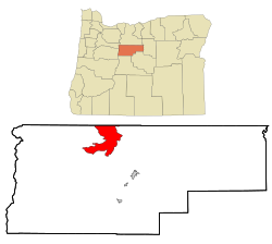
Terrebonne is an unincorporated community and census-designated place (CDP) in Deschutes County, Oregon, United States. It is part of the Bend, Oregon Metropolitan Statistical Area. The population was 1,257 at the 2010 census.

<span class="mw-page-title-main">Odell, Oregon</span> Unincorporated community in the state of Oregon, United States

Odell is an unincorporated community and census-designated place (CDP) in Hood River County, Oregon, United States. Odell was named for an early pioneer, William Odell, a native of Tennessee by way of California, who settled in the area in 1861. The population was 2,255 as of the 2010 census.

<span class="mw-page-title-main">Parkdale, Oregon</span> Unincorporated community in the state of Oregon, United States

Parkdale is an unincorporated community and census-designated place (CDP) in Hood River County, Oregon, United States. As of the 2010 census, the population was 311, up from 266 at the 2000 census.

<span class="mw-page-title-main">White City, Oregon</span> Unincorporated community in the state of Oregon, United States

White City is an unincorporated community and census-designated place (CDP) in Jackson County, Oregon, United States. The population was 7,975 at the 2010 census, up from 5,466 at the 2000 census. White City is about 9 miles (14 km) north of the center of Medford and 4 miles (6 km) south of Eagle Point.

<span class="mw-page-title-main">Four Corners, Oregon</span> Unincorporated community in the state of Oregon, United States

Four Corners is a census-designated place (CDP) in Marion County, Oregon, United States, just outside the city limits of Salem but within the city's urban growth boundary. It is part of the Salem Metropolitan Statistical Area. The population of the CDP was 16,740 at the 2020 census. It is named after the intersection of State Street and Lancaster Drive.

<span class="mw-page-title-main">Cloverdale, Oregon</span> Census-designated place in Oregon, United States

Cloverdale is an unincorporated community in Tillamook County, Oregon, United States. For statistical purposes, the United States Census Bureau has defined Cloverdale as a census-designated place (CDP). The census definition of the area may not precisely correspond to local understanding of the area with the same name. The population was 242 at the 2000 census.

<span class="mw-page-title-main">Hobart, Washington</span> Census-designated place in Washington, United States

Hobart is an unincorporated community and census-designated place (CDP) in King County, Washington, United States. The population was 6,767 at the 2020 census.

<span class="mw-page-title-main">Easton, Washington</span> Census-designated place in Washington, United States

Easton is an unincorporated community and census-designated place (CDP) in Kittitas County, Washington, United States. The population was 478 at the 2010 census. Easton is the annual site of the start/finish line for the Cascade Crest 100-mile ultra-running race.

<span class="mw-page-title-main">Ronald, Washington</span> Census-designated place in Washington, United States

Ronald is an unincorporated community and census-designated place (CDP) in Kittitas County, Washington, United States. The population was 308 at the 2010 census.

<span class="mw-page-title-main">Dallesport, Washington</span> Census-designated place in Washington, United States

Dallesport is an unincorporated community and census-designated place (CDP) in Klickitat County, Washington, United States. The population was 1,328 at the 2020 census.

<span class="mw-page-title-main">Lyle, Washington</span> Census-designated place in Washington, United States

Lyle is an unincorporated community and census-designated place (CDP) in Klickitat County, Washington, United States. The population was 499 at the 2010 census.

<span class="mw-page-title-main">Roosevelt, Washington</span> Census-designated place in Washington, United States

Roosevelt is an unincorporated community and census-designated place (CDP) in Klickitat County, Washington, United States. The population was 156 at the 2010 census, up from 79 at the 2000 census. The Roosevelt Regional Landfill, one of the largest landfills in the United States, is located at Roosevelt.

<span class="mw-page-title-main">Greenwater, Washington</span> CDP in Washington, United States

Greenwater is a census-designated place (CDP) in the northwest United States in Pierce County, Washington. Southeast of Seattle, the population was 67 at the 2010 census, down from 91 in 2000.

References

  1. "ArcGIS REST Services Directory". United States Census Bureau. Retrieved October 12, 2022.
  2. 1 2 "Census Population API". United States Census Bureau. Retrieved October 12, 2022.
  3. 1 2 "U.S. Census website". United States Census Bureau . Retrieved January 31, 2008.
  4. "US Board on Geographic Names". United States Geological Survey. October 25, 2007. Retrieved January 31, 2008.
  5. 1 2 "Warm Springs". Geographic Names Information System . United States Geological Survey, United States Department of the Interior. November 28, 1980. Retrieved August 29, 2010.
  6. 1 2 "Geographic Identifiers: 2010 Census Summary File 1 (G001): Warm Springs CDP, Oregon". American Factfinder. U.S. Census Bureau. Archived from the original on February 13, 2020. Retrieved October 31, 2018.
  7. "US Gazetteer files: 2010, 2000, and 1990". United States Census Bureau. February 12, 2011. Retrieved April 23, 2011.
  8. Climate Summary for Warm Springs, Oregon
  9. Moffatt, Riley. Population History of Western U.S. Cities & Towns, 1850–1990. Lanham: Scarecrow, 1996, 216.