Coleville is a village in the Canadian province of Saskatchewan within the Rural Municipality of Oakdale No. 320 and Census Division No. 13. The village's main economic factors are oil and farming, namesake of the Coleville oilfields. The village is named for Malcolm Cole who became the community's first postmaster in 1908.
Roblin is an unincorporated urban community in the Municipality of Roblin, Manitoba, Canada. It is located approximately 400 km (250 mi) northwest of Winnipeg.

The Rural Municipality of Corman Park No. 344 is a rural municipality (RM) in the Canadian province of Saskatchewan within Census Division No. 11 and SARM Division No. 5. Located in the central portion of the province, the RM surrounds the City of Saskatoon.
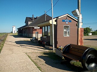
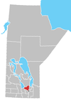
Rivers is an unincorporated urban community in the Riverdale Municipality within the Canadian province of Manitoba. It is located 40 kilometres (25 mi) northwest of Brandon, 473 metres (1,552 ft) above sea level. It is within the Westman Region. Agriculture, health and related businesses provide income for the community and area. Rivers has a population of 1,257 people in the 2016 census.

Togo is a village in the Canadian province of Saskatchewan within the Rural Municipality of Cote No. 271 and Census Division No. 9. It is 800 metres west of the Manitoba border and approximately 72 km (45 mi) northeast of the City of Yorkton.

Champion is a village in southern Alberta, Canada within Vulcan County. It is located on Highway 23, approximately 74 kilometres (46 mi) north of Lethbridge and 147 kilometres (91 mi) south of Calgary.

Springfield is a rural municipality (RM) in Manitoba, Canada. It stretches from urban industrial development on the eastern boundary of the city of Winnipeg, through urban, rural residential, agricultural and natural landscapes, to the Agassiz Provincial Forest on the municipality's eastern boundary. Birds Hill Provincial Park nestles into the north-western corner of Springfield.
Russell is an unincorporated urban community in the Municipality of Russell – Binscarth, Manitoba.
Ashmont, Alberta is a hamlet in northern Alberta, Canada within the County of St. Paul No. 19. It is located near the intersection of Highway 28 and Highway 36, approximately 33 kilometres (21 mi) northwest of the Town of St. Paul. It has an elevation is 2,073 feet (632 m).
Notre Dame de Lourdes is an unincorporated community recognized as a local urban district in the Municipality of Lorne within the Canadian province of Manitoba that held village status prior to January 1, 2015. It is located within the Central Plains Region, 100 km southwest of Winnipeg. The community had a population of 683 inhabitants in the 2011 census, an increase of 16.0% from the 589 inhabitants during the 2006 census.
Semans is a village in the Canadian province of Saskatchewan within the Rural Municipality of Mount Hope No. 279 and Census Division No. 10. The village is located approximately 125 km north of the City of Regina and 195 km southeast of the City of Saskatoon.
Cheadle is a hamlet in Alberta, Canada within Wheatland County. It is located on Highway 24, 2 kilometers (1.2 mi) south of the Highway 1 and approximately 35 kilometers (22 mi) east of the City of Calgary.

Gainsborough is a village in the Canadian province of Saskatchewan within the Rural Municipality of Argyle No. 1 and Census Division No. 1. A farming community, the village is located on Highway 18 in the southeastern corner of Saskatchewan. Gainsborough is approximately 6 km (3.7 mi) from the Manitoba border, and 19 km (12 mi) from the North Dakota, United States border. The first post office was established on April 1, 1884 as the community of Antler. On September 1, 1885 the name of the community changed to Gainsborough, after Gainsborough, Lincolnshire in England, which was the former home of J. J. Sadler, an early settler.
Woodlands is a rural municipality (RM) in the province of Manitoba in Western Canada. It lies in the southern part of the Interlake and is named for the community of Woodlands, which itself is named for the wooded lands of the area.
Ruthilda is a former village in the Rural Municipality of Grandview No. 349, Saskatchewan, Canada. It dissolved from village status to become part of the Rural Municipality of Grandview No. 349 on December 31, 2013. Ruthilda is located about 5 km south of Highway 51 approximately 30 km southwest of the Town of Biggar.

The Rural Municipality of Moose Mountain No. 63 is a rural municipality (RM) in the Canadian province of Saskatchewan within Census Division No. 1 and SARM Division No. 1. It is located in the south-east portion of the province.
Alexander, Manitoba, is a local urban district in the Rural Municipality of Whitehead, situated on Highway 1, west of Brandon.
Oak Bluff is an incorporated community located in the Rural Municipality of Macdonald, Manitoba, Canada. It is situated seven kilometres southwest of the City of Winnipeg, between Manitoba Highway (PTH) 3's intersections with PTH 2 and PTH 100. The community has a population of 1,442 as of the 2021 Canadian census
Gordon is an unincorporated community in Manitoba, Canada, within the Rural Municipality of Rosser. The community is centred on PTH 6, approximately 3.5 kilometres north-west of Winnipeg and 9.5 kilometres south-east of Grosse Isle. It is named for James Gordon, who was in charge of leases in the General Manager's Office of the Canadian National Railway.