Warrensburg (CDP), New York

Last updated

Warrensburg
CDP
USA New York location map.svg
Red pog.svg
Warrensburg
Location within the state of New York
Coordinates: 43°30′N73°46′W / 43.500°N 73.767°W / 43.500; -73.767
Country United States
State New York
County Warren
Town Warrensburg
Area
[1]
  Total6.96 sq mi (18.02 km2)
  Land6.76 sq mi (17.50 km2)
  Water0.20 sq mi (0.53 km2)
Elevation
745 ft (227 m)
Population
 (2020)
  Total3,045
  Density450.71/sq mi (174.03/km2)
Time zone UTC-5 (Eastern (EST))
  Summer (DST) UTC-4 (EDT)
ZIP code
12885
Area code 518
FIPS code 36-78289 [2]
GNIS feature ID0968825 [3]

Warrensburg is a census-designated place (CDP) in Warren County, New York, United States. The population was 3,045 at the 2020 census. [2] It is part of the Glens Falls Metropolitan Statistical Area. [4]

Contents

Warrensburg is located on U.S. Route 9, on the Schroon River, east of the Hudson River, and west of Interstate 87 (The Northway). The CDP is entirely within the town of Warrensburg.

According to the 2000 United States Census, the CDP comprises less than one-fifth of the town's total area, yet has about 75% of the town's population. [2] The CDP's population density is more than fourteen times that of the town outside the CDP. [2] Much of the town's historic core is within the Hamlet of Warrensburgh Historic District, listed on the National Register of Historic Places in 2001. [5] Also listed on the National Register of Historic Places are the Merrill MaGee House, Mixter Blacksmith Shop, and Warrensburg Mills Historic District. [5]

Geography

Lithograph of Warrensburgh published by L.R. Burleigh 1891 with list of landmarks Warrensburgh, N.Y. LOC 75694864.jpg
Lithograph of Warrensburgh published by L.R. Burleigh 1891 with list of landmarks

According to the United States Census Bureau, the CDP has a total area of 11.3 square miles (29.2 km2), of which 11.1 square miles (28.7 km2) is land and 0.2 square mile (0.5 km2) (1.86%) is water.

Warrensburg is located west of Lake George and is entirely inside the Adirondack Park.

Demographics

Historical population
CensusPop.Note
2020 3,045
U.S. Decennial Census [6] [2]

As of the census of 2000, there were 3,208 people, 1,297 households, and 865 families residing in the CDP. The population density was 289.4 inhabitants per square mile (111.7/km2). There were 1,453 housing units at an average density of 131.1 per square mile (50.6/km2). The racial makeup of the CDP was 98.38% White, 0.12% Black or African American, 0.09% Native American, 0.44% Asian, 0.09% from other races, and 0.87% from two or more races. Hispanic or Latino of any race were 0.50% of the population. [2]

There were 1,297 households, out of which 32.9% had children under the age of 18 living with them, 47.1% were married couples living together, 15.0% had a female householder with no husband present, and 33.3% were non-families. 26.8% of all households were made up of individuals, and 11.6% had someone living alone who was 65 years of age or older. The average household size was 2.42 and the average family size was 2.90. [2]

In the CDP, the population was spread out, with 25.0% under the age of 18, 7.2% from 18 to 24, 27.4% from 25 to 44, 25.7% from 45 to 64, and 14.6% who were 65 years of age or older. The median age was 39 years. For every 100 females, there were 88.4 males. For every 100 females age 18 and over, there were 82.5 males. [2]

The median income for a household in the CDP was $27,372, and the median income for a family was $32,689. Males had a median income of $31,322 versus $20,833 for females. The per capita income for the CDP was $15,585. About 14.1% of families and 17.7% of the population were below the poverty line, including 27.1% of those under age 18 and 6.7% of those age 65 or over. [2]

Transportation

Warrensburg is a flag stop for Trailways of New York between New York City and Montreal. [7]

Related Research Articles

<span class="mw-page-title-main">Georgetown, Connecticut</span> Census-designated place in Connecticut, United States

Georgetown is a census-designated place in Fairfield County, Connecticut, United States. It is located in the area where the towns of Wilton, Redding, Weston, and Ridgefield meet.

<span class="mw-page-title-main">Harris, Kansas</span> Unincorporated community in Anderson County, Kansas

Harris is an unincorporated community in Anderson County, Kansas, United States. As of the 2020 census, the population of the community and nearby areas was 47.

<span class="mw-page-title-main">Kingstown, Maryland</span> CDP in Maryland, United States

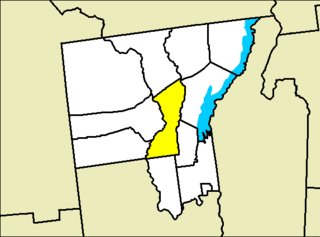
Kingstown is a census-designated place (CDP) in Queen Anne's County, Maryland, United States. The population was 1,644 at the 2000 census.

Clark Mills is a hamlet in Oneida County, New York, United States. The population was 1,905 at the 2010 census.

<span class="mw-page-title-main">Napanoch, New York</span> CDP in New York, United States

Napanoch is a hamlet in Ulster County, New York, United States. It is at the junction of routes 209 and 55. The population was 1,131 at the 2020 census. Napanoch is on the Shawangunk Ridge National Scenic Byway, and is part of the Hudson River Valley National Heritage Area.

<span class="mw-page-title-main">Stone Ridge, New York</span> CDP in New York, United States

Stone Ridge is a hamlet in Ulster County, New York, United States. The population was 1,234 at the 2020 census.

<span class="mw-page-title-main">Altamahaw, North Carolina</span> Census-designated place in North Carolina, United States

Altamahaw is a census-designated place (CDP) in Alamance County, North Carolina, United States. It is part of the Burlington, North Carolina Metropolitan Statistical Area. As of the 2010 census it had a population of 347. The community was listed as Altamahaw-Ossipee at the 2000 census, at which time the population was 996. The town of Ossipee incorporated in 2002 and currently has a population of 543. The remainder of the territory was reassigned as the Altamahaw CDP.

<span class="mw-page-title-main">Buies Creek, North Carolina</span> Census-designated place in North Carolina, United States

Buies Creek is a census-designated place (CDP) located in the Neills Creek Township of Harnett County, North Carolina, United States. It is the home of Campbell University. The population was 3,253 at the 2020 census, up from 2,942 in 2010. Buies Creek is a part of the Dunn Micropolitan Area, which is also a part of the greater Raleigh–Durham–Cary Combined Statistical Area (CSA) as defined by the United States Census Bureau.

<span class="mw-page-title-main">Etowah, North Carolina</span> Census-designated place in Henderson County, North Carolina, USA

Etowah is an unincorporated community and census-designated place (CDP) in Henderson County, North Carolina, United States. The population was 6,944 at the 2010 census. It is part of the Asheville Metropolitan Statistical Area.

<span class="mw-page-title-main">Hartstown, Pennsylvania</span> Census-designated place in Pennsylvania, United States

Hartstown is a census-designated place (CDP) in Crawford County, Pennsylvania, United States. The population was 201 at the 2010 census, down from 246 in 2000.

<span class="mw-page-title-main">Evansburg, Pennsylvania</span> Census-designated place in Pennsylvania, United States

Evansburg is a census-designated place (CDP) in Montgomery County, Pennsylvania, United States. The population was 2,129 at the 2010 census. It is a section of Lower Providence Township and is the namesake of Evansburg State Park.

<span class="mw-page-title-main">Willington, South Carolina</span> CDP in South Carolina, United States

Willington is a census-designated place (CDP) in McCormick County, South Carolina, United States. The population was 177 at the 2000 census.

<span class="mw-page-title-main">Roebuck, South Carolina</span> CDP in South Carolina, United States

Roebuck is a census-designated place (CDP) in Spartanburg County, South Carolina, United States. The population was 2,200 at the 2010 census.

<span class="mw-page-title-main">Rustburg, Virginia</span> Census-designated place in Virginia, United States

Rustburg is a census-designated place (CDP) in and the county seat of Campbell County, Virginia, United States. The population was 1,431 at the 2010 census. It is part of the Lynchburg Metropolitan Statistical Area.

<span class="mw-page-title-main">Gloucester Courthouse, Virginia</span> CDP in Virginia, United States

Gloucester Courthouse is a census-designated place (CDP) in and the county seat of Gloucester County, Virginia, United States. The population was 2,951 at the 2010 census.

Coeymans is a hamlet in Albany County, New York, United States. It is located on Route 144 in the southeastern part of the Town of Coeymans. The population was 835 at the 2000 census, which listed the community as a census-designated place (CDP), but it was not included as a CDP in the 2010 census.

<span class="mw-page-title-main">Constantia (CDP), New York</span> CDP in New York, United States

Constantia is a census-designated place (CDP) in the town of Constantia in Oswego County, New York, United States. Located on Oneida Lake, the community lies along State Route 49 and Scriba Creek. The population was 1,182 at the 2010 census.

<span class="mw-page-title-main">Middlebury (CDP), Vermont</span> Census-designated place in Vermont, United States

Middlebury is the main settlement in the town of Middlebury in Addison County, Vermont, United States, and a census-designated place (CDP). The population was 7,304 at the 2020 census, out of a total population of 9,152 in the town of Middlebury. Most of the village is listed on the National Register of Historic Places as the Middlebury Village Historic District.

<span class="mw-page-title-main">Warrensburg, New York</span> Town in New York, United States

Warrensburg is a town in Warren County, New York, United States. It is centrally located in the county, west of Lake George. It is part of the Glens Falls metropolitan area. The town population was 3,959 at the 2020 census. While the county is named after General Joseph Warren, the town is named after James Warren, a prominent early settler. U.S. Route 9 passes through the town, which is immediately west of Interstate 87.

Ontario is a hamlet and census-designated place (CDP) in the town of Ontario, Wayne County, New York, United States. The CDP extends into land surrounding the hamlet, including the east half of the hamlet of Ontario Center. The population of the CDP was 2,160 at the 2010 census. Government offices for the Town of Ontario are located in the hamlet.

References

  1. "ArcGIS REST Services Directory". United States Census Bureau. Retrieved September 20, 2022.
  2. 1 2 3 4 5 6 7 8 9 "U.S. Census website". United States Census Bureau . Retrieved January 31, 2008.
  3. "US Board on Geographic Names". United States Geological Survey. October 25, 2007. Retrieved January 31, 2008.
  4. "Metropolitan Areas and Components, 1999, with FIPS Codes". US Census Bureau. Retrieved July 7, 2009.
  5. 1 2 "National Register Information System". National Register of Historic Places . National Park Service. March 13, 2009.
  6. "Census of Population and Housing". Census.gov. Retrieved June 4, 2016.
  7. "Bus station details: Warrensburg, New York". Trailways. Retrieved July 19, 2023.