Warringah Civic Centre

Last updated

Warringah Civic Centre
Warringah Civic Centre (Front facade and entrance) May 2016.jpg
Front facade and entrance
Warringah Civic Centre
Former namesWarringah Shire Civic Centre
Alternative namesDee Why Civic Centre, Northern Beaches Civic Centre
General information
TypeGovernment town hall
Architectural style Brutalist style
AddressPittwater Road
Town or cityDee Why, New South Wales
CountryAustralia
Construction started1971
Completed1 September 1973
ClientWarringah Shire Council
Owner Northern Beaches Council (current)
Design and construction
Architect(s) Christopher Kringas
Colin Madigan
Bruce Mackenzie (landscape)
Architecture firmEdwards, Madigan, Torzillo and Briggs
Main contractorDowsett Engineering (Aust) Pty. Ltd.

The Warringah Civic Centre is a landmark civic building in Dee Why, a suburb of Sydney. It stands in the centre of Dee Why, along Pittwater Road. Designed in the Brutalist style by Christopher Kringas and Colin Madigan, it replaced the Warringah Shire Hall, a 1923 building also on Pittwater Road but in Brookvale opposite Brookvale Oval. The Civic Centre was the seat of Warringah Council from its opening on 1 September 1973 to 12 May 2016, when it became a seat (primary from September 2017) of the new Northern Beaches Council.

Contents

History

Early history and development

By the late 1960s, Warringah Shire Council had recognised the inefficiencies of their headquarters in the Shire Hall at Brookvale, and that it was far too small for the needs of the growing council. In December 1968, the Shire President Colin Huntingdon noted that "A new Shire Hall is so overdue it isn't funny. The staff are working in rabbit warrens which doesn't help efficiency." [1]

Brookvale remained the administrative centre for Warringah until 1971 when the council resolved to commence the construction of a new Civic Centre in Dee Why. When the council eventually moved to the new Civic Centre in 1973, the Warringah Shire Hall in Brookvale was threatened with demolition in the mid-1970s. Despite some calls for the historic hall to be saved and be used as a community centre, their efforts were to no avail and the hall was demolished in late 1978. [2]

Planning and completion

In the early 1960s, the Council initiated planning for a new 'Civic Centre' located in Dee Why to serve as a new home for the council. After commissioning architects Edwards Madigan Torzillo & Briggs, Kringas and Madigan came up with designs for a 'new acropolis' on a three-acre site along Pittwater Road that rises steeply from a flat coastal plain. In the early, ambitious stages of the masterplan design, Kringas and Madigan drew up a 100-year plan for the site, which included a civic centre, library, gymnasium, art gallery, public plaza and war memorial and a music auditorium. However, the vision proved too ambitious and council commissioned an initial project of the Dee Why Library. [3] The library, completed in 1966, was praised for its innovative modernist design and was awarded the 1966 Sir John Sulman Medal from the NSW Chapter of the Royal Australian Institute of Architects.

Kringas and Madigan were commissioned for the Civic Centre in 1970, which, although designed in a starker Brutalist style to the library, was created to complement the library and, like the library, to sit within the natural bushland setting of the site. The sympathetic landscape setting of native bushland was overseen by landscape architect Bruce Mackenzie. Work began on the Civic Centre in 1971. It was designed in conjunction with the development of the National Gallery and was completed in 1973. The centre adjoins Madigan and Kringas's earlier library. Together they form the first two elements of a proposed cultural and administrative complex. The Civic Centre has been described as a 'testing ground' for the National Gallery [1982] and High Court [1980]. [4]

The Civic Centre was officially opened on 1 September 1973 by the Shire President, Councillor Dick Legg, and has been the seat of the council since then. After completing the design of the High Court of Australia, Kringas died of bowel cancer in 1975, aged 38. Madigan was awarded the Gold Medal by the Royal Australian Institute of Architects for lifetime efforts in the field of architecture in 1981. In 2008 the Civic Centre precinct, including the library and surrounding bushland, was nominated for State Heritage listing. This was deferred, but has again been nominated in 2017, with the centre precinct being noted as "significant examples of the Brutalist Style demonstrating the move away from the constraints of the modular structural systems to a more flexible form of architecture" and as "of state heritage significance for its aesthetic significance and landmark qualities derived largely from the integration of the sculptural man-made elements with natural landscape elements." [5] The Civic Centre precinct has been listed on the NSW Chapter of the Australian Institute of Architects' register of Nationally Significant 20th-Century Architecture. [6]

See also

Related Research Articles

Brutalist architecture is an architectural style that emerged during the 1950s in the United Kingdom, among the reconstruction projects of the post-war era but commonly known for its presence in post-war communist nations. Brutalist buildings are characterised by minimalist constructions that showcase the bare building materials and structural elements over decorative design. The style commonly makes use of exposed, unpainted concrete or brick, angular geometric shapes and a predominantly monochrome colour palette; other materials, such as steel, timber, and glass, are also featured.

<span class="mw-page-title-main">Northern Beaches</span> Region in New South Wales, Australia

The Northern Beaches is a region within Northern Sydney, in the state of New South Wales, Australia, near the Pacific coast. This area extends south to the entrance of Port Jackson, west to Middle Harbour and north to the entrance of Broken Bay. The area was formerly inhabited by the Garigal or Caregal people in a region known as Guringai country.

<span class="mw-page-title-main">Pittwater Council</span> Former local government area in New South Wales, Australia

Pittwater Council was a local government area on the Northern Beaches of Sydney, in the state of New South Wales, Australia. It covered a region adjacent to the Tasman Sea about 30 kilometres (19 mi) north of the Sydney central business district. The area is named after Pittwater, the body of water adjacent to much of the area governed. First proclaimed in 1906 as the A Riding of Warringah Shire, the area was proclaimed as the Municipality of Pittwater on 1 May 1992. On 12 May 2016, the Minister for Local Government announced that Pittwater Council would be subsumed into the newly formed Northern Beaches Council. The last mayor of Pittwater Council was Councillor Jacqui Townsend, an independent politician.

<span class="mw-page-title-main">Warringah Council</span> Former local government area in New South Wales, Australia

Warringah Council was a local government area in the northern beaches region of Sydney, in the state of New South Wales, Australia. It was proclaimed on 7 March 1906 as the Warringah Shire Council, and became "Warringah Council" in 1993. In 1992, Pittwater Council was formed when the former A Riding of Warringah Shire voted to secede. From this point on until amalgamation, Warringah Council administered 152 square kilometres (59 sq mi) of land, including nine beaches and 14 kilometres (9 mi) of coastline. Prior to its abolition it contained 6,000 hectares of natural bushland and open space, with Narrabeen Lagoon marking Warringah's northern boundary and Manly Lagoon marking the southern boundary.

<span class="mw-page-title-main">Wynyard railway station, Sydney</span> Heritage-listed railway station in Sydney, New South Wales, Australia

Wynyard railway station is a heritage-listed underground commuter rail station located in the north-west precinct of the Sydney central business district, in New South Wales, Australia. The station opened on 28 February 1932 to coincide with the opening of the Sydney Harbour Bridge.

<span class="mw-page-title-main">Dee Why</span> Suburb of Sydney, New South Wales, Australia

Dee Why is a coastal suburb of northern Sydney, in the state of New South Wales, Australia, 18 kilometres north-east of the Sydney central business district. It is the administrative centre of the local government area of Northern Beaches Council and, along with Brookvale, is considered to be the main centre of the Northern Beaches region.

<span class="mw-page-title-main">Division of Warringah</span> Australian federal electoral division

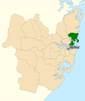
The Division of Warringah is an Australian electoral division in the state of New South Wales.

Forestville is a suburb of Northern Sydney, in the state of New South Wales, Australia. Forestville is 12 kilometres north of the Sydney central business district in the local government area of Northern Beaches Council. Forestville is part of the Forest District.

Warringah is a name taken from the local Aboriginal word for Middle Harbour, in Sydney, New South Wales, Australia. It may refer to:

<span class="mw-page-title-main">Curl Curl</span> Suburb of Sydney, New South Wales, Australia

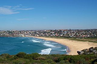
Curl Curl is a suburb of northern Sydney in the state of New South Wales, Australia, 18 kilometres (11 mi) north-east of the Sydney central business district, in the local government area of Northern Beaches Council. It is part of the Northern Beaches region.

<span class="mw-page-title-main">Brookvale, New South Wales</span> Suburb of Sydney, New South Wales, Australia

Brookvale is a suburb of northern Sydney, in the state of New South Wales, Australia. Brookvale is 16 kilometres north-east of the Sydney central business district, in the local government area of Northern Beaches Council. It is part of the Northern Beaches region.

<span class="mw-page-title-main">Westfield Warringah Mall</span> Shopping mall in New South Wales, Australia

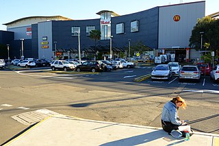
Westfield Warringah Mall is a large indoor/outdoor shopping centre in the suburb of Brookvale in the Northern Beaches region of Sydney.

Colin Frederick Madigan AO was an Australian architect. He is best known for designing the National Gallery of Australia in Canberra.

Michael John Regan is an Australian politician and former public servant. He was mayor of Warringah Council from 13 September 2008 to May 2016 following its amalgamation into the Northern Beaches Council. In September 2017, Regan was elected as the first Mayor of Northern Beaches Council, holding office until May 2023. At the March 2023 state election, Regan was elected to the NSW Legislative Assembly seat of Wakehurst, which covers a large portion of the area of Northern Beaches Council.

<span class="mw-page-title-main">Mackellar County Council</span>

The Mackellar County Council (MCC) was a state–owned enterprise of the Government of New South Wales, Australia. Established in 1951, it was an electricity and gas supplier and retailer which primarily supplied the Northern Beaches area of Sydney, New South Wales, being jointly managed and operated by Manly Municipal Council and Warringah Shire Council.

<span class="mw-page-title-main">Warringah Shire Hall</span> Government town hall in New South Wales, Australia

The Warringah Shire Hall was an Australian municipal town hall located on Pittwater Road opposite Robert Street in Brookvale, a suburb of the Northern Beaches of Sydney, New South Wales. Initially built in 1910 as a Federation bungalow, the complex was expanded with the addition of "Shire Hall" in 1912, the final form was completed in 1923 with the addition of a second floor to a design by Trenchard Smith and Maisey. The Shire Hall was the seat of Warringah Council from 1910 to 1973, when the council moved to a new purpose-built Civic Centre on further down Pittwater Road in Dee Why. The Shire Hall survived amid uncertainty over its future but was eventually sold and demolished in 1978.

<span class="mw-page-title-main">Northern Beaches Council</span> Local government area in New South Wales, Australia

The Northern Beaches Council is a local government area located in the Northern Beaches region of Sydney, in the state of New South Wales, Australia. The council was formed on 12 May 2016 after the amalgamation of Manly, Pittwater, and Warringah councils.

<span class="mw-page-title-main">Feiko Bouman</span> Dutch Australian architect and author

Feiko Bouman is a Dutch Australian architect and author, best known for his outback museum, The Australian Stockman’s Hall of Fame, Longreach Queensland. The building was opened by Queen Elizabeth in 1988.

<span class="mw-page-title-main">High Court of Australia Building</span> Court house in ACT, Australia

The High Court of Australia building is located on the shore of Lake Burley Griffin in Canberra's Parliamentary Triangle. It has been the permanent home of the High Court of Australia since 1980. The High Court building was designed between 1972 and 1974 by the Australian architect Christopher Kringas (1936–1975) – a director of the firm Edwards Madigan Torzillo and Briggs – who is commemorated by a plaque in the public hall.

<span class="mw-page-title-main">Christopher Kringas</span> Australian Architect

Christopher Kringas (1936-1975) is best known as the architect of the High Court of Australia.

References

  1. Carpenter, Paul (22 December 1968). "'Hot seat man' ready for action". The Sydney Morning Herald. Retrieved 18 January 2016.
  2. Morcombe, John (15 October 2015). "Councils continuously purge urge to merge but government may force the issue". The Manly Daily. Retrieved 29 February 2016.
  3. Lewi, Dr. Hannah (7 July 2011). "Life Cycle: Warringah Shire Civic Centre". Australian Design Review. Retrieved 31 March 2015.
  4. "Warringah Council Civic Centre Dee Why" (PDF). Fiche Report. Docomomo Australia. 2010. Retrieved 31 March 2015.
  5. "Warringah Civic Centre Precinct (under consideration)". Heritage Items register. Office of Environment and Heritage. Retrieved 9 September 2017.
  6. "Warringah Shire Council Civic Centre & Library precinct, Warringah. (formerly Dee Why Library)" (PDF). Nationally Significant 20th-Century Architecture. Australian Institute of Architecture. Retrieved 9 September 2017.

33°45′05″S151°17′13″E / 33.7513°S 151.2870°E / -33.7513; 151.2870