
Door County is the easternmost county in the U.S. state of Wisconsin. As of the 2020 census, the population was 30,066. Its county seat is Sturgeon Bay, making it one of three Wisconsin counties on Lake Michigan not to have a county seat with the same name. Instead it is named after the strait between the Door Peninsula and Washington Island. The dangerous passage, known as Death's Door, contains shipwrecks and was known to Native Americans and early French explorers. The county was created in 1851 and organized in 1861. Door County is a popular Upper Midwest vacation destination. It is home to a small Walloon population.

Washington Island is a town in northern Door County, Wisconsin, United States, with a population of 708 at the 2010 census. The unincorporated communities of Detroit Harbor and Washington are located in the town.

Menasha is a city in Calumet and Winnebago counties in the U.S. state of Wisconsin. The population was 17,353 at the 2010 census. Of this, 15,144 were in Winnebago County, and 2,209 were in Calumet County. The city is located mostly in Winnebago County; only a small portion is in the Town of Harrison in Calumet County. Doty Island is located partially in Menasha. The city's name comes from the Winnebago word meaning "thorn" or "island". In the Menominee language, it is known as Menāēhsaeh, meaning "little island". Menasha is home to the Barlow Planetarium and Weis Earth Science Museum, both housed at the University of Wisconsin-Fox Valley.

Port Washington is the county seat of Ozaukee County in the U.S. state of Wisconsin. Located on Lake Michigan's western shore east of Interstate 43, the community is a suburb in the Milwaukee metropolitan area 27 miles north of the City of Milwaukee. The city's artificial harbor at the mouth of Sauk Creek was dredged in the 1870s and was a commercial port until the early 2000s. The population was 11,250 at the 2010 census.
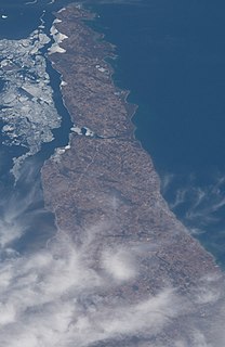
The Door Peninsula is a peninsula in eastern Wisconsin, separating the southern part of the Green Bay from Lake Michigan. The peninsula includes northern Kewaunee County, northeastern Brown County, and the mainland portion of Door County. It is on the western side of the Niagara Escarpment. Well known for its cherry and apple orchards, the Door Peninsula is a popular tourism destination. With the 1881 completion of the Sturgeon Bay Ship Canal, the northern half of the peninsula became an island.

Gills Rock is an unincorporated community located on Highway 42 at the northern tip of the Door Peninsula in Door County, Wisconsin, United States. It is within the town of Liberty Grove and was formerly known as Hedgehog Harbor.

Washington Island is an island of the state of Wisconsin situated in Lake Michigan. Lying about 7 miles (11 km) northeast of the tip of the Door Peninsula, it is part of Door County, Wisconsin. The island has a year-round population of 708 people according to the 2010 census. It has a land area of 60.89 km² and comprises over 92 percent of the land area of the town of Washington, as well as all of its population. The unincorporated community of Detroit Harbor is situated on the island. It is the largest in a group of islands that includes Plum, Detroit, Hog, Pilot, Fish, and Rock Islands. These islands form the Town of Washington. Detroit Harbor bay is on the south side of the island. A large part of Washington Island's economy is based on tourism.
Belgian Americans are Americans who can trace their ancestry to immigrants from Belgium who emigrated to the United States. While the first natives of the then-Southern Netherlands arrived in America in the 17th century, the majority of Belgian immigrants arrived during the 19th and 20th centuries.
Bethel was a city described in the Hebrew Bible.

Bethel is a rural unincorporated community located west of U.S. Route 259 in McCurtain County, Oklahoma, United States. The post office opened January 24, 1900. The ZIP code is 74724.
Namur, Wisconsin is an unincorporated community in the town of Union in Door County, Wisconsin. The community is located on County Road DK at its intersection with County Road N. It is located approximately 5 miles west of the unincorporated community of Brussels, Wisconsin. The community is located inside the Namur Historic District, a historic district of farms near the community.
The Potawatomi Islands is the most common historic name given to the string of islands that delineate the transition from Green Bay to Lake Michigan, one of the Great Lakes. The archipelago is also termed the "Grand Traverse Islands".
Bethel is an unincorporated community located in the town of Richfield, in Wood County, Wisconsin, United States.

Detroit Harbor is an unincorporated community located in the Town of Washington Island on Washington Island in Door County, Wisconsin. The Washington Island Ferry runs scheduled passenger service to Northport from Detroit Harbor. Detroit Harbor is also home to a United States Post Office and Coast Guard Station Washington Island. A bay named Detroit Harbor is adjacent to the community.
Center is an unincorporated community in the Town of Center, Rock County, Wisconsin, United States. Located in section 22 of Township 3 North Range 11 East of the Fourth Principal Meridian, Center has been published on USGS maps since 1891. Bethel Cemetery, the Town of Center town hall and Zion Lutheran Church are located in the community in section 22 at the intersection of Rock County Highway A and Church Road.
Detroit Harbor is a bay between the southern end of Washington Island, and the northern end of Detroit Island. It is located in Washington, Door County, Wisconsin. An unincorporated community also named Detroit Harbor is found on the northern side of the bay. There are three islands inside of the bay, Snake Island, Big Susie Island, and Little Susie Island. The bay is dredged on either side to allow boats through, forming the East and West channels. Both car and passenger ferries to Washington Island go through Detroit Harbor, before they dock. The United States Coast Guard maintains operations in Detroit Harbor through the Washington Island Station. Detroit Harbor is designated as a Wisconsin State Natural Area by the Wisconsin Department of Natural Resources.
The flora of Door County, Wisconsin comprise a variety of plant species. Geobotanically, Door County belongs to the North American Atlantic Region.

Little Lake is a lake located in Door County, Wisconsin. The lake is found on Washington Island in Green Bay of Lake Michigan. Little Lake has a surface area of 41 acres (0.17 km2) and a max depth of 6 ft (1.8 m). Most of the lake is shallow and has a bottom that is muck. Although the northwest corner of the lake is only 250 ft (76 m) from Lake Michigan, the lake is spring fed. It is a recursive lake, due to it being a lake on an island. The shore around the lake is partially owned by the Door County Land Trust. This area is designated as a Wisconsin State Natural Area by the Wisconsin Department of Natural Resources.


