Related Research Articles

Emery County is a county in east-central Utah, United States. As of the 2010 United States Census, the population was 10,976. Its county seat is Castle Dale, and the largest city is Huntington.
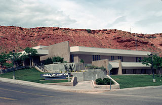
Washington County is a county in the southwestern corner of Utah, United States. As of the 2010 United States Census, the population was 138,115, making it the fifth-most populous county in Utah. Its county seat and largest city is St. George. The county was created in 1852 and organized in 1856. It was named after the first President of the United States, George Washington. In 2008, a Yahoo News article stated that Washington County had the fifth-highest job-growth rate in the United States. A portion of the Paiute Indian Reservation is in western Washington County. Washington County comprises the St. George, UT Metropolitan Statistical Area.

Hurricane is a city in Washington County, Utah, United States. Its population was 13,748 at the 2010 U.S. Census. Along with several other areas of southwestern Utah, the Hurricane area has undergone large population growth since the 1970s.

La Verkin is a city in Washington County, Utah, United States. The population was 4,060 as of 2010, an increase from 3,392 in 2000. La Verkin is within walking distance of Hurricane, and the two cities have historically had close ties.

The geology of the Zion and Kolob canyons area includes nine known exposed formations, all visible in Zion National Park in the U.S. state of Utah. Together, these formations represent about 150 million years of mostly Mesozoic-aged sedimentation in that part of North America. Part of a super-sequence of rock units called the Grand Staircase, the formations exposed in the Zion and Kolob area were deposited in several different environments that range from the warm shallow seas of the Kaibab and Moenkopi formations, streams and lakes of the Chinle, Moenave, and Kayenta formations to the large deserts of the Navajo and Temple Cap formations and dry near shore environments of the Carmel Formation.

The Metropolitan Water District of Southern California is a regional wholesaler and the largest supplier of treated water in the United States. The name is usually shortened to "Met," "Metropolitan," or "MWD." It is a cooperative of fourteen cities, eleven municipal water districts, and one county water authority, that provides water to 19 million people in a 5,200-square-mile (13,000 km2) service area. It was created by an act of the California Legislature in 1928, primarily to build and operate the Colorado River Aqueduct. Metropolitan became the first contractor to the State Water Project in 1960.

The Washington Suburban Sanitary Commission is a bi-county political subdivision of the State of Maryland that provides safe drinking water and wastewater treatment for Montgomery and Prince George's Counties in Maryland except for a few cities in both counties that continue to operate their own water facilities.
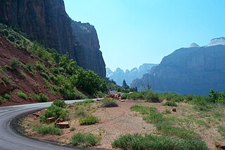
State Route 9 (SR-9) is a 57.075-mile-long (91.853 km) state highway in southern Utah, serving Zion National Park. It starts at the western terminus at exit 16 on Interstate 15 (I-15), passing through Zion National Park, and ending at the eastern junction with U.S. Route 89 (US-89). The entire length of the highway has been designated the Zion Park Scenic Byway. There is a fee to travel through Zion National Park, but the Zion-Mt. Carmel Highway is open to private vehicles year-round. A separate fee is required for vehicles 7'10" wide and/or 11'4" tall or larger. This fee pays for a park employee to stop traffic from the other side of the Zion - Mt. Carmel Tunnel to allow the larger vehicles to pass through. There is a smaller tunnel in Zion National Park that does not require an escort. Commercial vehicles are prohibited from using SR-9 and are directed to use SR-20 instead.
Dallas Water Utilities (DWU) is the water and wastewater service operated by the City of Dallas, Texas, in the United States. DWU is a non-profit City of Dallas department that provides services to the city and 31 nearby communities, employs approximately 1450 people, and consists of 26 programs. DWU's budget is completely funded through the rates charged for water and wastewater services provided to customers. Rates are based on the cost of providing the services. The department does not receive any tax revenues. Primary authority and rules for the department are listed in Chapter 49 of the Dallas City Code.
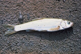
The Virgin spinedace is a cyprinid fish of the Virgin River, a tributary of the Colorado River in the United States.
Clean Water Services is the water resources management utility for more than 600,000 residents in urban Washington County, Oregon and small portions of Multnomah County, Oregon and Clackamas County, Oregon, in the United States. Clean Water Services operates four wastewater treatment facilities, constructs and maintains flood management and water quality projects, and manages flow into the Tualatin River to improve water quality and protect fish habitat. They are headquartered in Hillsboro.
The Central Utah Project is a US federal water project that was authorized for construction under the Colorado River Storage Project Act of April 11, 1956, as a participating project. In general, the Central Utah Project develops a portion of Utah's share of the yield of the Colorado River, as set out in the Colorado River Compact of 1922.
In Section 203(a) of the Central Utah Project Completion Act, the United States Congress authorized a federally authorized and funded replacement project to replace the Uinta and Upalco Units of the Central Utah Project (CUP) which were not constructed. The replacement project is the Uinta Basin Replacement Project (UBRP). The UBRP will provide: 2,500 acre-feet (3,100,000 m3) of irrigation water; 3,000 acre-feet (3,700,000 m3) of municipal and industrial water; reduced wilderness impacts; increased instream flows; and improved recreation. Design work began in 2002. Construction began in 2004 and is anticipated to be completed in 2011. The Central Utah Water Conservancy District is responsible for construction. The United States Department of the Interior oversees funding and compliance with law and environmental regulation.

Zion National Park is an American national park located in southwestern Utah near the town of Springdale. A prominent feature of the 229-square-mile (590 km2) park is Zion Canyon, which is 15 miles (24 km) long and up to 2,640 ft (800 m) deep. The canyon walls are reddish and tan-colored Navajo Sandstone eroded by the North Fork of the Virgin River. The lowest point in the park is 3,666 ft (1,117 m) at Coalpits Wash and the highest peak is 8,726 ft (2,660 m) at Horse Ranch Mountain. Located at the junction of the Colorado Plateau, Great Basin, and Mojave Desert regions, the park has a unique geography and a variety of life zones that allow for unusual plant and animal diversity. Numerous plant species as well as 289 species of birds, 75 mammals, and 32 reptiles inhabit the park's four life zones: desert, riparian, woodland, and coniferous forest. Zion National Park includes mountains, canyons, buttes, mesas, monoliths, rivers, slot canyons, and natural arches.

LaVerkin Creek Wilderness is a 445-acre (1.8 km2) wilderness area in the US state of Utah. It was designated March 30, 2009, as part of the Omnibus Public Land Management Act of 2009. Located adjacent to the Kolob Canyons region of Zion National Park, it encompasses and protects the upper headwaters of LaVerkin Creek, a tributary of the Wild & Scenic Virgin River. Another portion of the creek is protected by the Blackridge Canyon Wilderness. LaVerkin Creek Wilderness is bordered by the Zion Wilderness to the south.
Beartrap Canyon Wilderness is a 40-acre (0.2 km2) wilderness area in the US state of Utah. It was designated March 30, 2009, as part of the Omnibus Public Land Management Act of 2009. Located adjacent to the Kolob Canyons region of Zion National Park, it encompasses and protects part of Beartrap Canyon Creek, a tributary of the Wild & Scenic Virgin River. Beartrap Canyon Wilderness is bordered by the Zion Wilderness to the east.
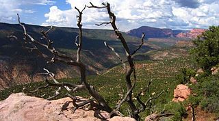
Blackridge Wilderness is a 13,108-acre (5,305 ha) wilderness area in the state of Utah. It was designated March 30, 2009, as part of the Omnibus Public Land Management Act of 2009. Located adjacent to the Kolob Canyons section of Zion National Park, it protects a Black Ridge, formed by the Hurricane Fault, as well as a long stretch of LaVerkin Creek, a tributary of the Wild and Scenic Virgin River. Blackridge Wilderness is bordered by the Zion Wilderness to the northeast.

Quail Creek State Park is a state park of Utah, United States, featuring a 600-acre (240 ha) reservoir. The park is located within Hurricane, Utah, 9 miles (14 km) west of the city center and 1.5 miles (2.4 km) south of the historic ghost town of Harrisburg. Quail Creek State Park offers camping, boating, swimming, and fishing.

Beatty Point is a 7,780-foot (2,370 m) elevation summit located in the Kolob Canyons area of Zion National Park in Washington County, Utah, United States.
References
- ↑ Mission and History
- 1 2 Municipal
- ↑ Retail
- 1 2 3 Water Treatment Plant
- ↑ Infrastructure
- ↑ Wells
- ↑ Pipelines
- ↑ "Reservoirs" . Retrieved 2020-10-10.
- ↑ "Hydro Plants" . Retrieved 2020-10-10.
- ↑ Wastewater
- ↑ Water Conservation Plan, December 2015
- ↑ Secondary
- ↑ Toquerville Springs / Water Development in Toquerville
- ↑ Hot Springs
- ↑ Does St. George really need Lake Powell water?
- ↑ "LPP Permitting Steps and Milestones" . Retrieved 2021-10-10.
- ↑ Cost and Repayment
- ↑ Chapter 28 / Lake Powell Pipeline Development Act