
The Missouri Botanical Garden is a botanical garden located at 4344 Shaw Boulevard in St. Louis, Missouri. It is also known informally as Shaw's Garden for founder and philanthropist Henry Shaw. Its herbarium, with more than 6.6 million specimens, is the second largest in North America, behind that of the New York Botanical Garden.

The South Carolina State Museum has four floors of permanent and changing exhibits, a digital dome planetarium, 4D interactive theater and an observatory. The State Museum, is located along the banks of the Congaree River in downtown Columbia, South Carolina. It is the largest museum in the state, and is a Smithsonian Affiliate and part of the American Alliance of Museums. Positioned on an old shipping canal that dates back to pre-Civil War times, the museum is widely recognized as a resource for South Carolina history and lifestyle. The museum opened on October 29, 1988 and is housed in what it calls its largest artifact, the former Columbia Mills Building, listed on the National Register of Historic Places in 1982. When the mill opened in 1894, manufacturing cotton duck cloth, it was the first totally electric textile mill in the world. It was also the first major industrial installation for the General Electric corporation. On certain levels of the museum, the original flooring has been kept intact, distinguishable by hundreds of textile brads and rings that became embedded in the floor while it was still being used as a mill. The South Carolina Confederate Relic Room & Military Museum is located within the Columbia Mills Building, and is the oldest museum exhibit in Columbia.

Druid Hill Park is a 745-acre (3.01 km2) urban park in northwest Baltimore, Maryland. Its boundaries are marked by Druid Park Drive (north), Swann Drive and Reisterstown Road, and the Jones Falls Expressway / Interstate 83 (east).

The Central West End is a neighborhood in St. Louis, Missouri, stretching from Midtown's western edge to Union Boulevard and bordering on Forest Park with its outstanding array of free cultural institutions. It includes the Cathedral Basilica of Saint Louis on Lindell Boulevard at Newstead Avenue, which houses the largest collection of mosaics in the world. The Central West End is represented by three aldermen as it sits partially in the 17th, 18th, and 28th Wards.

Stix, Baer and Fuller was a department store chain in St. Louis, Missouri that operated from 1892 to 1984.

The Washington Avenue Historic District is located in Downtown West, St. Louis, Missouri along Washington Avenue, and bounded by Delmar Boulevard to the north, Locust Street to the south, 8th Street on the east, and 18th Street on the west. The buildings date from the late 19th century to the early 1920s. They exhibit a variety of popular architectural styles of those years, but most are revival styles or in the commercial style that would later come to be known as the Chicago School of architecture. Most are large multi-story buildings of brick and stone construction, built as warehouses for the St. Louis garment district. Many have terra cotta accents on their facades. After World War II, the decline in domestic garment production and the preference for single-story industrial space led to many of the buildings being vacant or underused due to functional obsolescence.
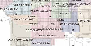
Marconi Plaza is an urban park square located in South Philadelphia, Philadelphia, Pennsylvania. The plaza was named to recognize the 20th-century cultural identity in Philadelphia of the surrounding Italian-American enclave neighborhood and became the designation location of the annual Columbus Day Parade.

Castle Hill refers to either a 165-acre (67 ha) drumlin surrounded by sea and salt marsh or to the mansion that sits on the hill. Both are part of the 2,100-acre (850 ha) Crane Estate located on Argilla Road in Ipswich, Massachusetts. The former summer home of Mr. and Mrs. Richard T. Crane, Jr., the estate includes a historic mansion, 21 outbuildings, and designed landscapes overlooking Ipswich Bay, on the seacoast off Route 1, north of Boston. Its name derives from a promontory in Ipswich, Suffolk, England, whence many early Massachusetts Bay Colony settlers immigrated, and predates the Crane mansion.
Henry Wright (1878-1936), was a planner, architect, and major proponent of the garden city, an idea characterized by green belts and created by Sir Ebenezer Howard.

Theodore C. Link, FAIA, was a German-born American architect and newspaper publisher. He designed buildings for the 1904 World's Fair, Louisiana State University, and the Mississippi State Capitol.

The Upper Eastside is a neighborhood in Miami, Florida, United States. It is north of Edgewater, east of Little Haiti, south of the village of Miami Shores, and sits on Biscayne Bay. In geographical order from south to north and east to west, it contains the subdivisions of Magnolia Park, Bay Point, Morningside, Bayside, Belle Meade, Shorecrest, and Palm Grove. The MiMo District along Biscayne Boulevard in the area is host to many art galleries, shops and restaurants.

Parkview, also known as a "Saint Louis Urban Oasis," is a historic, private subdivision of St. Louis, Missouri. It is partly within the city limits of St. Louis and partly in University City. It is bounded by the Skinker-DeBaliviere neighborhood to the east, the Delmar Loop to the north, the Ames Place section of University City to the west, Washington University to the south, and Forest Park to the southeast.
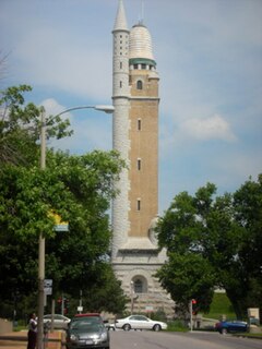
The Compton Heights historic neighborhood, located near the south side of St. Louis, Missouri in the shadow of the great water tower of Reservoir Park, is one of the earliest planned residential developments of the American nineteenth century. Laid out in 1889 in accordance with a plan that viewed nature as neighbor and not as an enemy to be subjugated by some rectilinear grid, its wide setbacks and curving streets create remarkable vistas, which are punctuated by more than 200 homes of extraordinary and varied interest. The entire neighborhood is a national historic district.
A private place is a self-governing enclave whose common areas are owned by the residents, and whose services are provided by the private sector.
Julius Pitzman (1837–1923) was a Prussian-born American surveyor and city planner best known for his development of the private, gated neighborhoods in St. Louis, Missouri from 1867 through about 1914.

John Lawrence Mauran, FAIA was an American architect responsible for many downtown landmarks in St. Louis, Missouri. He was also active in Wisconsin and Texas.

The architecture of St. Louis exhibits a variety of commercial, residential, and monumental architecture. St. Louis is known for the Gateway Arch, the tallest monument constructed in the United States. Architectural influences reflected in the area include French Colonial, German, early American, European influenced, French Second Empire, Victorian, and modern architectural styles.

The Hi-Pointe–DeMun Historic District is a historic district that was listed on the National Register of Historic Places in 2005. The district, commonly referred to as “DeMun,” is a neighborhood straddling the city limits of St. Louis, Missouri and Clayton, Missouri. The district is roughly bounded by Clayton Road to the south, Big Bend Boulevard to the west, Northwood Avenue to the north, and Skinker Boulevard to the east, and consists of two subdivisions: DeMun Park and Hi-Pointe.
Frederick Widmann (1859-1925) was a German-born American architect and philanthropist.
George William Hellmuth (1870-1955) was an American architect based in St. Louis, Missouri.


