Water resources management in Syria

Last updated
The Barada river, shown here in Damascus in 2009, is the only notable river flowing entirely within Syrian territory Barada river in Damascus (April 2009).jpg
The Barada river, shown here in Damascus in 2009, is the only notable river flowing entirely within Syrian territory

Water resources management in Syria is confronted with numerous challenges. First, all of the country's major rivers are shared with neighboring countries, and Syria depends to a large extent on the inflow of water from Turkey through the Euphrates and its tributaries. Second, high population growth and urbanisation increase the pressure on water resources, resulting in localized groundwater depletion and pollution, for example in the Ghouta near Damascus. Third, there is no legal framework for integrated water resources management. Finally, the institutions in charge of water resources management are weak, being both highly centralized and fragmented between sectors, and they often lack the power to enforce regulations. Water resources policies have been focused on the construction of dams, the development of irrigated agriculture and occasional interbasin transfers, such as a pipeline to supply drinking water to Aleppo from the Euphrates. There are 165 dams in Syria with a total storage capacity of 19.6 km³. [1] Demand management through metering, higher tariffs, more efficient irrigation technologies and the reduction of non-revenue water in drinking water supply has received less emphasis than supply management. The government implements a large program for the construction of wastewater treatment plants including the use of reclaimed water for irrigation.

Contents

Water is regulated by the Ministry of Water Resources.

Water resources base

The Euphrates River, shown here near Raqqa, is the most important water source for Syria. ArRaqqahEuphrates.jpg
The Euphrates River, shown here near Raqqa, is the most important water source for Syria.

Surface water

The most important rivers of Syria are the Euphrates, the Tigris, the Orontes and the Yarmouk River. All these rivers are shared between Syria and its neighbors. The Euphrates, by far the most important river in Syria, flows from Turkey through Syria to Iraq. In Syria, it is joined by the Khabur and the Balikh rivers, which both originate in the Syro-Turkish border region. The Tigris River originates in the eastern Taurus Mountains in Turkey and forms the border between Syria and Turkey on a small mountainous stretch of the river. Its mean annual flow is 18 km³/year, but very little can be used by Syria due to its remote location. The Orontes River, which flows from Lebanon through Syria to Turkey, has an average flow of 0.4 km³/year (13 m³/s). The water resources of the Yarmouk River, which is shared with Jordan and Israel and flows into the Jordan River, average some 0.4 km³/year (14 m³/s).

Among Syria's smaller rivers is the Barada River, which flows through Damascus and is one of the few notable rivers that flows entirely inside Syrian territory. The Quweiq River flows from Turkey to Syria and the city of Aleppo. The Nahr al-Kabir al-Shamali (Northern Great River) rises in Turkey and flows through the northern coastal plain and Latakia. The Nahr al-Kabir al-Janoubi (Southern Great River) flows through the southern coastal plain and, on its lower stretch, forms the border between Syria and Lebanon. It has an average flow of 0.3 km³/year (8 m³/s). Both rivers form part of what is called the "coastal basin", which is actually a group of small river basins in Syria that drain to the Mediterranean.

International agreements on transboundary rivers

While Syria has signed written agreements with its neighbors on transboundary rivers, none of these agreements is an international treaty that would have to be ratified by the Parliaments of the respective countries. The agreements are rather non-binding memorandums of understanding. [2]

Euphrates River. In 1989 Iraq and Syria signed a water-sharing agreement under which a maximum of 42% (210 m³/s) of the surface water inflow through the Euphrates granted by Turkey unilaterally to the downstream riparians (500 m³/s) were considered as Syria’s share. [3] There is no final agreement regarding the Syrian water rights on the Euphrates and Tigris rivers. However, since 2005 a group of scholars and retired officials from Syria, Iraq and Turkey initiated Track II diplomacy under the Euphrates-Tigris Initiative for Cooperation. Its aim is to promote cooperation among the three countries, including through a joint data inventory. [2] In March 2008 the three riparian countries formed a joint "water institute" based in Turkey that will "work toward the solution of water-related problems among the three". [4]

The Yarmouk River forms the border between Jordan and Syria Yarmooch.jpg
The Yarmouk River forms the border between Jordan and Syria

Orontes River. There is an agreement between Lebanon and Syria over the Orontes signed in 1994, which stipulates that Lebanon receives 80 million cubic meters of water per year "if the river flow inside Lebanon is 400 million cubic meters per year or more". This means that the risk of drought is borne by Lebanon. No new wells were allowed to be drilled in the Lebanese portion of the Orontes basin since the agreement has been signed. [2] [5]

There is apparently no such agreement over the Orontes between Syria and Turkey. However, in March 2008 Syria and Turkey reportedly agreed to jointly build a dam on the river, which suggests that some kind of agreement has been made. [4]

Yarmouk River. In 1987 Syria and Jordan signed an agreement about the sharing of the river's water and have subsequently built a dam, the Unity Dam, on the border between the two countries.

Groundwater

Historical groundwater recharge has been estimated at 4 km³/year, out of which 2 km³/year was estimated to discharge through springs into rivers (average 1977–2001). [6] After deducting this "overlap" between surface water and groundwater net renewable groundwater resources were estimated at 2 km³/year. Groundwater in Syria is heavily overexploited (see below).

Overall estimates

Estimates of water resources in Syria vary greatly, which is due to different assumptions about inflows from and outflows to other countries, different methodologies to account for overlaps between surface water and groundwater, and poor data. For example, one report estimates "internal" renewable water resources at 7.1 km³/year (long-term average 1977–2001), taking into account overlaps between data between surface water and groundwater. [1] However, UNDP estimates the renewable surface and groundwater resources at 10 km³/year. [7] FAO estimates "total actual renewable water resources" at 16.8 km³/year. The same report estimates "actual external renewable surface water resources" at 17.3 km³/year, including 15.8 km³ of water "entering" with the Euphrates, as unilaterally proposed by Turkey, 0.3 km³ of water "entering" with the Asi-Orontes, as agreed with Lebanon, and 1.3 km³/year from the Tigris. [8] No specific estimates are provided for outflows of surface water to neighboring countries. If 58% of the flow of the Euphrates entering Syria (9.16 km³/year) are considered Iraq's share as stipulated in the 1989 agreement, actual water resources available to Syria would be much lower than stated above. Finally, official data are questionable because better hydro-geological investigations of groundwater are needed to obtain more reliable data. [9]

Water use

Total annual water withdrawal was estimated at 19.4 km³/year in 2008-2009, including 2.4 km³/year taken by depleting groundwater and surface water reservoirs. [10] It was estimated at 16.7 km³/year in 2003, 88% of which was for agricultural purposes. [8]

Overexploitation of groundwater

In some basins, such as that of the Barada around Damascus, total water use exceeds availability of renewable water resources, resulting in overexploitation of groundwater. In the Mleita plain around the town of Al-Nabk in the Kalamoon Mountains north of Damascus, for example, the water table declined from 35 meter in 1984 to below 250 meter in 2009. Agriculture all but disappeared and the fertile valley was turned into a dusty wasteland. [11] Other areas of heavy groundwater overexploitation are the area around Mhardeh in Hama Governorate, Khan Shaykhun in Idlib Governorate and the Damascus Ghouta where groundwater levels dropped by more than 6 meters per year in some areas between 1993 and 2000. Overexploitation of groundwater has contributed to a decline in the flow of the Khabur River which has ceased to flow during summer since 1999. The number of wells in Syria has been estimated to have increased from 135,089 in 1999 to over 213,335 in 2007, according to the National Agricultural Policy Centre (NAPC). The lands irrigated by groundwater increased from 652,000ha in 1985 to 1.4m ha in 2005. Rural electrification, diesel subsidies and subsidized loans for the drilling and equipment of wells contributed to the boom in groundwater irrigation. [12]

Water pollution

According to the Syrian National Environmental Action Plan of 2003, surface and groundwater are contaminated in many areas with domestic and industrial wastewater. For example, in the Barada River concentrations of biological oxygen demand (BOD) and ammonia exceeded Syrian Standards for 86% of collected samples between 1995 and 2000. Well and spring water in the basin is bacteriologically contaminated because of sewage discharge. The concentrations of nitrates in some wells in the Ghouta near Damascus exceeded the limits set by the drinking water standards. Because of discharges by tanneries concentrations of Chromium III reach 10 mg/liter in Al Daiyani River and exceed the allowable limits ten-fold in the wells of Al Zablatini area, all located in the Barada basin. [7]

On the Orontes River analyses of water samples for ammonia, suspended solids and BOD indicated that concentrations exceeded the allowable limits, particularly in the lower part of the river. In the upper part, water quality is acceptable. On the Quweiq River flowing through Aleppo concentrations of BOD, ammonia and heavy metals exceeded allowable limits. In the coastal region wells used for drinking purposes are contaminated with high concentrations of nitrates and ammonia because of sewage discharge and use of fertilizers. Water salinity is also high in some wells because of seawater intrusion into the fresh groundwater aquifers. [7]

Dams

The Tabqa Dam, Syria's largest dam, and Lake Assad on the Euphrates from space, June 1996. North is at the top left of the image. Tabaqah assad.jpg
The Tabqa Dam, Syria's largest dam, and Lake Assad on the Euphrates from space, June 1996. North is at the top left of the image.

There are 165 dams in Syria with a total storage capacity of 19.6 km³. [1] By far the largest dam is the Tabqa Dam, located near Raqqa on the Euphrates and forming Lake Assad. Its purpose is production of hydropower, irrigation and storage of water for drinking water for Aleppo. Medium-size dams include the Al-Rastan (0.2 km³), the Lake Homs Dam (Qattinah) (0.2 km³), the Mouhardeh (0.07 km³) and the Taldo (0.02 km³). [8] In 2007 there were 49 dams on the Orontes River with a total storage capacity of 1.5 km³, or more than three times the average annual flow of the river. There were 42 dams on the Yarmouk with a total storage capacity of 0.3 km³. Twenty-one dams are located in the coastal area with a total storage capacity of 0.6 km³.

A comprehensive regulatory framework for integrated water resources management does not exist in Syria. Over 140 laws dealing with water have been passed since 1924. Prohibitions on well drilling and groundwater pollution have been passed, but there are no clear mechanisms for their enforcement. [8] The Syrian water sector is both highly centralized and fragmented between sector institutions that have overlapping functions and responsibilities. A Council of General Commission for Water Resource Management is in charge of integrating water policies between various Ministries. [8] According to another source there is a Higher Water Committee, which is presided by the Deputy Prime Minister for service affairs. [7] According to a report on Syria's water resources, "one of the consequences of the fragmentation and lack of coordination within the water sector is that key water resource data are not exchanged between the different institutions, which in turn hampers effective policy making." [12]

Ministries with responsibilities related to water resources management include:

Water resources assessment and planning

From 2002 to 2004, the Ministry of Irrigation, with the support of Dutch development cooperation, prepared an integrated water resources management plan for the coastal basins. The project included detailed water resources assessment studies, the analysis and selection of strategies and an action plan developed in consultation with various government stakeholders. [13] From 2002 onwards, a Water Resources Information Center in the Ministry of Irrigation has been established with the assistance of JICA. The center established Geographical Information Systems for the Barada-Awaj Basin around Damascus and the coastal basins, including data on groundwater, surface water and water quality. [14]

Syria plans to irrigate 25,000ha in the Northeast by pumping water from the Tigris. [2]

Water shortages during the Syrian Civil War

During the Wadi Barada offensive, there were periods of water shortages in Damascus due to rebels' control of Ain al-Fijah in late 2016, [15] until it was controlled by the Syrian army in early 2017. [16] [17]

In 2020, the Turkish authorities started to cut water supplies from the Euphrates, which caused huge water shortages in Al-Hasakah Governorate. [18] Those schemes might have been used to affect the Kurdish-controlled areas in north Syria. [19] [20]

See also

Related Research Articles

<span class="mw-page-title-main">Euphrates</span> River in Turkey, Iraq, and Syria

The Euphrates is the longest and one of the most historically important rivers of Western Asia. Together with the Tigris, it is one of the two defining rivers of Mesopotamia. Originating in Turkey, the Euphrates flows through Syria and Iraq to join the Tigris in the Shatt al-Arab, which empties into the Persian Gulf.

<span class="mw-page-title-main">Geography of Syria</span> Geographical features of Syria

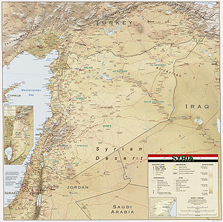
Syria is located in Western Asia, north of the Arabian Peninsula, at the eastern end of the Mediterranean Sea. It is bordered by Turkey to the north, Lebanon and Israel to the west and southwest, Iraq to the east, and Jordan to the south. It consists of mountain ranges in the west and a steep area inland. In the east is the Syrian Desert and in the south is the Jabal al-Druze Range. The former is bisected by the Euphrates valley. A dam built in 1973 on the Euphrates created a reservoir named Lake Assad, the largest lake in Syria. The highest point in Syria is Mount Hermon on the Lebanese border at 2,814 metres or 9,232 feet. Between the humid Mediterranean coast and the arid desert regions lies a semiarid steep zone extending across three-quarters of the country, which receives hot, dry winds blowing across the desert. Syria is extensively depleted, with 28 percent of the land arable, 4 percent dedicated to permanent crops, 46 percent utilized as meadows and pastures, and only 3 percent forest and woodland.

<span class="mw-page-title-main">Tigris</span> River in Turkey, Iraq, and Syria

The Tigris is the easternmost of the two great rivers that define Mesopotamia, the other being the Euphrates. The river flows south from the mountains of the Armenian Highlands through the Syrian and Arabian Deserts, and empties into the Persian Gulf.

<span class="mw-page-title-main">Tigris–Euphrates river system</span> River system in the Middle East

The Tigris–Euphrates river system is a large river system in Western Asia which discharges into the Persian Gulf. Its principal rivers are the Tigris and Euphrates along with smaller tributaries.

<span class="mw-page-title-main">Barada</span> River in Syria

The Barada is the main river of Damascus, the capital city of Syria.

The Atatürk Dam, originally the Karababa Dam, is the third largest dam in the world and it is a zoned rock-fill dam with a central core on the Euphrates River on the border of Adıyaman Province and Şanlıurfa Province in the Southeastern Anatolia Region of Turkey. Built both to generate electricity and to irrigate the plains in the region, it was renamed in honour of Mustafa Kemal Atatürk (1881–1938), the founder of the Turkish Republic. The construction began in 1983 and was completed in 1990. The dam and the hydroelectric power plant, which went into service after the upfilling of the reservoir was completed in 1992, are operated by the State Hydraulic Works (DSİ). The reservoir created behind the dam, called Atatürk Reservoir, is the third largest in Turkey.

<span class="mw-page-title-main">Tabqa Dam</span> Dam in Raqqa Governorate, Syria

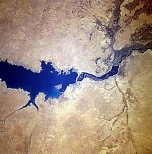
The Tabqa Dam, or al-Thawra Dam as it is also named, most commonly known as Euphrates Dam, is an earthen dam on the Euphrates, located 40 kilometres (25 mi) upstream from the city of Raqqa in Raqqa Governorate, Syria. The city of Al-Thawrah is located immediately south of the dam. The dam is 60 metres (200 ft) high and 4.5 kilometres (2.8 mi) long and is the largest dam in Syria. Its construction led to the creation of Lake Assad, Syria's largest water reservoir. The dam was constructed between 1968 and 1973 with help from the Soviet Union. At the same time, an international effort was made to excavate and document as many archaeological remains as possible in the area of the future lake before they would be flooded by the rising water. When the flow of the Euphrates was reduced in 1974 to fill the lake behind the dam, a dispute broke out between Syria and Iraq that was settled by intervention from Saudi Arabia and the Soviet Union. The dam was originally built to generate hydroelectric power, as well as irrigate lands on both sides of the Euphrates. The dam has not reached its full potential in either of these objectives.

<span class="mw-page-title-main">Lake Assad</span> Reservoir on the Syrian Euphrates

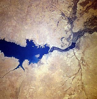
Lake Assad is a reservoir on the Euphrates in Raqqa Governorate, Syria. It was created in 1974 when construction of the Tabqa Dam was completed. Lake Assad is Syria's largest lake, with a maximum capacity of 11.7 cubic kilometres (2.8 cu mi) and a maximum surface area of 610 square kilometres (240 sq mi). A vast network of canals uses water from Lake Assad to irrigate lands on both sides of the Euphrates. In addition, the lake provides drinking water for the city of Aleppo and supports a fishing industry. The shores of Lake Assad have developed into important ecological zones.

<span class="mw-page-title-main">State Hydraulic Works (Turkey)</span> Government agency of Turkey

The State Hydraulic Works is a state agency, under the Ministry of Environment and Forestry of Turkey, responsible for the utilization of all the country's water resources. The institution's four major functions are energy, agriculture, services and environment. The General Manager of DSI is Kaya Yıldız.

<span class="mw-page-title-main">Water conflict</span> Conflict over an access to water resources

Water conflict is a term describing a conflict between countries, states, or groups over the rights to access water resources. The United Nations recognizes that water disputes result from opposing interests of water users, public or private. A wide range of water conflicts appear throughout history, though rarely are traditional wars waged over water alone. Instead, water has historically been a source of tension and a factor in conflicts that start for other reasons. Water conflicts arise for several reasons, including territorial disputes, a fight for resources, and strategic advantage.

<span class="mw-page-title-main">Water politics in the Middle East</span>

Water politics in the Middle East deals with control of the water resources of the Middle East, an arid region where issues of the use, supply, control, and allocation of water are of central economic importance. Politically contested watersheds include the Tigris–Euphrates river system which drains to the south-east through Iraq into the Persian Gulf, the Nile basin which drains northward through Egypt into the eastern Mediterranean Sea, and the Jordan River basin which flows into the Dead Sea, a land-locked and highly saline sea bordered by Jordan to the east and Israel to the west.

Syria is a semi-arid country with scarce water resources. The largest water-consuming sector in Syria is agriculture. Domestic water use is only about 9% of total water use. A big challenge for Syria is its high population growth, with a rapidly increasing demand for urban and industrial water. In 2006, the population of Syria was 19.4 million with a growth rate of 2.7%.

Water politics in the Jordan River basin refers to political issues of water within the Jordan River drainage basin, including competing claims and water usage, and issues of riparian rights of surface water along transnational rivers, as well as the availability and usage of ground water. Water resources in the region are scarce, and these issues directly affect the five political subdivisions located within and bordering the basin, which were created since the collapse, during World War I, of the former single controlling entity, the Ottoman Empire. Because of the scarcity of water and a unique political context, issues of both supply and usage outside the physical limits of the basin have been included historically.

Water resources management in El Salvador is characterized by difficulties in addressing severe water pollution throughout much of the country's surface waters due to untreated discharges of agricultural, domestic and industrial run off. The river that drains the capital city of San Salvador is considered to be polluted beyond the capability of most treatment procedures.

Water management in Greater Damascus, a metropolitan area with more than 4 million inhabitants, is characterized by numerous challenges, including groundwater overexploitation, increasing water demand, intermittent supply, and pollution. These challenges could be exacerbated by the impact of climate change, since projections indicate that a decrease in rainfall is likely. The quality of residential water supply mirrors social divisions within the metropolitan area, with the poorest neighborhoods receiving the worst service. Irrigation in the rural parts of Greater Damascus, in particular in the Ghouta, still accounts for about 70% of water use in the metropolitan area, with the remainder being used for residential, commercial and industrial use.

Water supply and sanitation in Lebanon is characterized by a number of achievements and challenges. The achievements include the reconstruction of infrastructure after the 1975–90 Civil War and the 2006 war with Israel, as well as the reform of the water and sanitation sector through a water law passed in 2000. The law created four Regional Water Establishments to consolidate numerous smaller utilities.

Water supply and sanitation in Iraq is characterized by poor water and service quality. Three decades of war, combined with limited environmental awareness, have destroyed Iraq's water resources management system. Thus, Iraq faces difficulties to realize the target of 91% of households using safe drinking water supply by 2015. Currently, 16% of households report daily problems with supply and 20% use an unsafe drinking water source. Furthermore, animal waste and septic tanks pollute the drinking water network.(11)

Water conflict in the Middle East and North Africa (MENA) primarily deals with three major river basins: the Jordan River Basin, the Tigris-Euphrates River Basin, and the Nile River Basin. The MENA region covers roughly 11.1 million square km. There are three major deserts in the MENA region:

<span class="mw-page-title-main">Afrin Dam</span> Dam in northwest Syria

The Afrin Dam, officially 17 April Dam, also called Maydanki Dam, is an earth-filled water storage and hydroelectric power dam on the Afrin River in northwest Syria. It provides drinking water to almost 200,000 people, irrigates about 30,000 hectares of olives, fruit trees and agricultural crops, and supplies 25 MW of hydroelectric power. It is currently under the control of the Turkish Land Forces.

References

  1. 1 2 3 FAO:FAO Water Report 43 (2009), accessed on October 31, 2009
  2. 1 2 3 4 Syria Today:Parting the Waters, by John Dagge, January 2010, accessed on January 18, 2010
  3. Syria Today:Syrian-Turkish Hydrodiplomacy, by Marwa Daoudy, January 2010, accessed on January 18, 2010
  4. 1 2 Today's Zaman:Turkey, Iraq, Syria to initiate water talks, 12 March 2000, accessed on October 31, 2009
  5. Oregon State University: Transboundary Freshwater Dispute Database, International Freshwater Treaties Database: Bilateral agreement, Act No. 15 concerning the division of the water of Al-Asi River (Orontes) between the Syrian Arab Republic and the Lebanese Republic, September 20, 1994, retrieved on February 5, 2010
  6. World Resources Institute:Water Resources and Freshwater Ecosystems-- Syrian Arab Republic,[ dead link ] 2003, based on FAO Aquastat 2002
  7. 1 2 3 4 The Ministry of State for Environmental Affairs/World Bank/United Nations Development Program:Strategy and National Environmental Action Plan for Syria, 2003, accessed on October 31, 2009
  8. 1 2 3 4 5 FAO:FAO Aquastat Country Profile, 2008, accessed on October 31, 2009
  9. Federal Ministry for Economic Cooperation and Development (Germany) & Ministry of Irrigation (Syria). Initial Assessment Study of Water Sector Management in the Syrian Arab Republic, Final Report. Damascus, September 2004
  10. Syria Today:Q&A: Nader al-Bunni, Syrian Minister of Irrigation, by Francesca de Châtel, January 2010, accessed on January 18, 2010
  11. Syria Today:When Every Drop Counts, by Francesca de Châtel, January 2010, accessed on January 18, 2010
  12. 1 2 Syria Today:Mining the Deep, by Francesca de Châtel, January 2010, accessed on January 18, 2010
  13. DHV:Coastal Water Resources Management Project 2002-2004, presentation at the seminar on Dutch-Syrian water cooperation, November 22, 2004
  14. Water Resources Information Center, Ministry of Irrigation, Syria, WRIC Chief Advisor Noriyuki Mori, JICA, presentation at the seminar on Dutch-Syrian water cooperation, November 22, 2004
  15. "Damascus water supply cut after rebels pollute it: authority". Reuters. 23 December 2016.
  16. "Update on water cuts in Syria". UNICEF. 6 January 2017.
  17. "Syria regains Damascus water supply plant". BBC. 28 January 2017.
  18. "2020: The year of the worst water shortage in Hassakeh, Syria". icrc.org. 2020.
  19. "The role of water in the Syrian and Iraqi Civil Wars". clingendael.org. 5 March 2020.
  20. "Syria: Are water supplies being weaponized by Turkey?". DW. 24 January 2021.

Further reading