Watford Gap

Last updated
Watford Gap: West Coast Main Line and M1 motorway in parallel WCML and M1.jpg
Watford Gap: West Coast Main Line and M1 motorway in parallel
Grand Union Canal at Watford Gap. Watford Gap - Grand Union Canal - geograph.org.uk - 71453.jpg
Grand Union Canal at Watford Gap.

Watford Gap is a low-lying area between two hills, close to the village of Watford, Northamptonshire, England. Engineers from Roman times onwards have found it to be an ideal route for connecting the Midlands with South East England. The A5 road, the West Coast Main Line railway, the M1 motorway and a branch of the Grand Union Canal traverse in parallel a space about 400 metres (1,300 ft) wide. It has been written and spoken of as marking the divide between Northern England and Southern England.

Contents

Focal point

Watford Gap is a low point through a range of hills providing an easy route between the South Eastern and Midland areas of England. It is near the small village of Watford, Northamptonshire. The gap is 3.5 miles (6 km) north-east of Daventry and 2 miles (3 km) west of Long Buckby. In the era of Roman Britain, the Watling Street Roman road used the gap. The road here forms the A5, which for national journeys has generally been superseded by the M1 motorway which also passes through this gap.

Later the road was joined by the Leicester Line of the Grand Union Canal, which passes through the Watford Locks just to the north of the gap.

The historical geographic importance of the area led to many modern communication routes passing through this narrow gap: the coming of the railways brought the London and Birmingham Railway, now known as the West Coast Main Line; the most recent addition, in 1959, was the M1, Britain's first inter-urban motorway, bringing with it Watford Gap services, the first motorway service station.

Division

Geological divide

Topographically the gap is a pass caused by a tectonic plate shift[ citation needed ], between east and west hill ranges. A tributary of the River Nene rises at Watford and flows east to the Wash, whereas at Kilsby a tributary of the River Leam rises and flows west.

Sociological divide

Isogloss

Foot-strut split isogloss Foot-strut split.svg
Foot-strut split isogloss

In linguistics the Watford Gap is often regarded as where England experiences its division of north and south dialects. It is close to the north/south isogloss of the three key hallmarks of Northern English and Southern English: foot–strut split, bad-lad split and the Bath vowel.

North/South divide

Making use of the above linguistic divide, authors, journalists [1] [2] and social commentators have written and spoken of a north–south divide between Northern England and Southern England (although, in this context, the reference is sometimes assumed to be to the town of Watford in Hertfordshire, some 61 miles / 98 km to the southeast by road).

The expression "North of Watford" is used to mean the north of England, especially a place remote from London. [3] This is often taken to mean "North of Watford Gap" because of the Watford Gap services being a main stopping point on the M1 motorway. [4] However, the original expression was already in use many years before the Watford Gap Service Station or M1 opened in 1959. [5] [6] [7] It is unknown whether the original expression referred to Watford, Northamptonshire, or the much larger Watford town in Hertfordshire, which was the last urban stop on the main railway line out of London to the north of England. There is evidence to support the latter, as the phrase "North of Watford Junction" was used with similar meaning in the past, referring to Watford Junction railway station at Watford, Hertfordshire. [8] [9] [10]

Stagecoach route

Historically, this was a junction of the West Midlands to London or East Anglia stagecoach routes across England. Its coaching inn, the Watford Gap, plied the passing trade of the area.

The pub, as well as the route from Cambridge to Coventry, is mentioned as early as 1769. [11] This route ran through Northampton, Duston, Harlestone, past Althorp Park, Brington, Long Buckby, Watford, Watford Gap itself—the map indicating that the coaching inn was on the west side of Watling Street, and then into Kilsby. The route from Watford Gap to Kilsby is now part of the diverted A5 road following construction of the M1 motorway.

The location of the Watford Gap coaching inn is the subject of confusion, with a location on the east side of the Grand Junction Canal (within the confines of the modern service station) being the most frequently cited, near the disused Welton railway station. There is no mention of a Watford Gap pub or any other pub at the suggested location on the 1889 or 1927 or 1952 Ordnance Survey maps of Northamptonshire. The nearest pub was the now-closed Stag's Head Inn in Station Road, Watford. The original location is further north on Watling Street. The canal-side building still stands but is closed for business and in poor repair.[ citation needed ] The earlier Watford Gap Inn is in good repair and generally unaltered, with the stabling yards and main structures used as farm buildings.

Motorway service station

The village is near to Watford Gap services on the M1 motorway, which was the first motorway service station in the United Kingdom.

Cultural references

Roy Harper's 1977 album Bullinamingvase contains a song titled "Watford Gap". Motorway service areas, which have since undergone radical innovations, were at the time in the United Kingdom typecast as spartan. The owners of Watford Gap services objected to his first reference to the place being ("Watford Gap, Watford Gap / A plate of grease and a load of crap…"). Harper was advised[ by whom? ] to drop the track from future UK copies of the album, though it reappeared on a CD reissue and remained on the American LP.[ citation needed ]

Related Research Articles

<span class="mw-page-title-main">M1 motorway</span> First inter-urban motorway in the UK

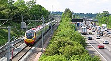
The M1 motorway connects London to Leeds, where it joins the A1(M) near Aberford, to connect to Newcastle. It was the first inter-urban motorway to be completed in the UK; the first motorway in the country was the Preston Bypass, which later became part of the M6.

<span class="mw-page-title-main">Long Buckby</span> Human settlement in England

Long Buckby is a large village and civil parish in West Northamptonshire, England. In the 2021 census the parish of Long Buckby, which includes the hamlet of Long Buckby Wharf, was recorded as having a population of 4,511.

<span class="mw-page-title-main">London and Birmingham Railway</span> Early British railway company (1837–1846)

The London and Birmingham Railway (L&BR) was a railway company in the United Kingdom, in operation from 1833 to 1846, when it became part of the London and North Western Railway (L&NWR).

<span class="mw-page-title-main">Daventry</span> Market town and civil parish in Northamptonshire, England

Daventry is a market town and civil parish in the West Northamptonshire unitary authority area of Northamptonshire, England, close to the border with Warwickshire. At the 2021 Census, Daventry had a population of 28,123, making it the sixth-largest town in Northamptonshire.

<span class="mw-page-title-main">A41 road</span> Road in England

The A41 is a trunk road between London and Liverpool, England. Now in parts replaced by motorways, it passes through or near Watford, Kings Langley, Hemel Hempstead, Aylesbury, Bicester, Solihull, Birmingham, West Bromwich, Wolverhampton, Newport, Whitchurch, Chester and Ellesmere Port.

<span class="mw-page-title-main">A5 road (Great Britain)</span> Major road in England and Wales

The A5, the London-Holyhead trunk road, is a major road in England and Wales. It runs for about 243 miles (391 km) from London to the Irish Sea at the ferry port of Holyhead. In many parts the route follows that of the Roman Iter II route which later took the Anglo-Saxon name Watling Street.

<span class="mw-page-title-main">A361 road</span> Longest three-digit road in England

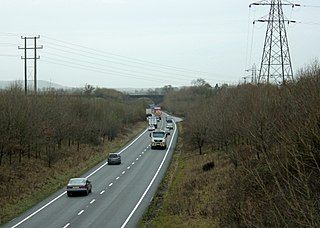
The A361 is an A class road in southern England, which at 195 miles (314 km) is the longest three-digit A road in the UK.

<span class="mw-page-title-main">Watford, Northamptonshire</span> Village and civil parish in England

Watford is a village and civil parish in West Northamptonshire in England. At the time of the 2001 census, the parish's population was 224 people, including Murcott and increasing to 320 at the 2011 Census. Watford is home to Watford Gap services, the UK's oldest motorway service station, located directly on the M1 motorway and alongside the West Coast Main Line.

<span class="mw-page-title-main">Whilton Locks</span>

Whilton Locks is the name of a flight of seven locks on the Grand Union Canal near Daventry, in the county of Northamptonshire, England. They are also referred to as Buckby Lock Flight.

<span class="mw-page-title-main">Norton, Northamptonshire</span> Human settlement in England

Norton is a village in West Northamptonshire. The population including Brokhall and Norton at the 2011 census was 434. The village is about 2 miles (3.2 km) east of Daventry, 11 miles (18 km) west of Northampton. Junction 16 of the M1 motorway is about 7 miles (11 km) south-east and the nearest railway station is at Long Buckby 3 miles (5 km) to the east. Near the village, on Watling Street, is the Roman settlement of Bannaventa.

<span class="mw-page-title-main">Kilsby</span> Human settlement in England

Kilsby is a village and civil parish in West Northamptonshire, England. It is situated a short distance south of the border with Warwickshire approximately five miles southeast of Rugby. The parish of Kilsby, which includes Barby Nortoft, was estimated to have a population of 1,268 in 2020.

<span class="mw-page-title-main">Watford Locks</span>

Watford Locks is a group of seven locks on the Leicester Line of the Grand Union Canal, in Northamptonshire, England, famous for the Watford Gap service area.

<span class="mw-page-title-main">Welton, Northamptonshire</span> Human settlement in England

Welton is a village and civil parish in the English county of Northamptonshire. The village is located 2.6 miles (4.2 km) north of the nearest town Daventry. It is 13 miles (21 km) west-north west of Northampton, 9 miles (14 km) south east of Rugby and 78 miles (126 km) north-west of London. The village is 1 mile (1.6 km) off the A361 that runs between Daventry and Crick where the A5 and the M1 junction 18 gives access to the national motorway network north and south. Welton formerly had its own railway station, but today, the nearest railway station is at Long Buckby for the West Midlands Trains services to Birmingham New Street, Northampton and London Euston stations, on the Northampton loop of the West Coast Main Line. For inter-city services, passengers should change at Rugby, the next station westbound. The Village and parish of Welton had in the 2021 census, a population of 596. For the purposes of local government, the village falls within West Northamptonshire.

<span class="mw-page-title-main">Northampton loop</span>

The Northampton loop is a railway line serving the town of Northampton. It is a branch of the West Coast Main Line, deviating from the faster direct main line which runs to the west. The WCML is a four track line up to either end of the Loop: the 'up' and 'down' fast tracks take the direct route while the 'up' and 'down' slow tracks are diverted via Northampton railway station. Generally, fast express trains run via the direct line, while freight and slower passenger services run via the loop line.

<span class="mw-page-title-main">Watford Gap services</span> Motorway services in Northamptonshire, England

Watford Gap services are motorway services on the M1 motorway in Northamptonshire, England. They opened on 2 November 1959, the same day as the M1, making them one of the oldest motorway services in Britain. The facilities were originally managed by Blue Boar, a local company that had run a nearby petrol station before the M1 opened. Roadchef bought the services from Blue Boar in 1995.

<span class="mw-page-title-main">Blisworth</span> Human settlement in England

Blisworth is a village and civil parish in the West Northamptonshire, England. The West Coast Main Line, from London Euston to Manchester and Scotland, runs alongside the village partly hidden and partly on an embankment. The Grand Union Canal passes through the village and the north portal of the Blisworth tunnel is near Stoke Road.

<span class="mw-page-title-main">Milton Keynes grid road system</span> Top layer of street hierarchy

The Milton Keynes grid road system is a network of predominantly national speed limit, fully landscaped routes that form the top layer of the street hierarchy for both private and public transport in Milton Keynes, Buckinghamshire. The system is unique in the United Kingdom for its innovative use of street hierarchy principles: the grid roads run in between districts rather than through them. This arrangement permits higher speed limits due to the absence of buildings close to the roads – although more recently some have been limited in part to 40 mph (64 km/h). The grid road system also serves an important purpose of discouraging through-traffic from travelling through neighbourhoods and thus reduces traffic noise and pollution in pedestrian areas. Motor traffic is segregated from pedestrian and leisure cycling traffic, which uses the alternative Milton Keynes redway system. Almost all grid junctions are roundabouts, and the absence of traffic lights enables free and efficient movement of traffic.

<span class="mw-page-title-main">Transport in Buckinghamshire</span>

Transport in Buckinghamshire has been shaped by its position within the United Kingdom. Most routes between the UK's two largest cities, London and Birmingham, pass through this county. The county's growing industry first brought canals to the area, then railways and then motorways.

<span class="mw-page-title-main">Welton railway station</span> Former railway station in Northamptonshire, England

Welton was a railway station on the West Coast Main Line serving the villages of Welton and Watford in Northamptonshire. The station was opened in 1838 as part of the London and Birmingham Railway. It was located closer to Watford than to Welton, however it was named after the latter in order to avoid confusion with the much larger town of Watford further south. The station had an unusual arrangement of staggered platforms, one platform on each side of the road bridge. This was because of the confined site, being hemmed in by the Grand Union Canal and A5 road.

<span class="mw-page-title-main">Houlton, Warwickshire</span> Human settlement in England

Houlton is a large housing development to the east of Rugby, Warwickshire, England. It is located between the Rugby suburb of Hillmorton, Warwickshire and Crick, Northamptonshire, west of the A5 road and M1 motorway.

References

  1. Jennings, Charles (26 February 2008). "Why the Watford Gap will never be Bridged". The Daily Telegraph . Retrieved 8 July 2013.
  2. Nugent, Helen (5 July 2013). "Northern Soul: my antidote to Fleet Street's abandonment of the North". The Guardian . Retrieved 8 July 2013.
  3. Longman Dictionary
  4. Robshaw, Brandon (7 August 2017). "North of Watford Gap". WordPress.
  5. Manchester Evening News , 23 May 1949
  6. Staffordshire Sentinel , 7 November 1950
  7. Birmingham Daily Gazette , 4 February 1953
  8. Birmingham Daily Post, 8 May 1967
  9. Birmingham Daily Post, 29 December 1970
  10. Liverpool Echo, 1 January 1972
  11. "unimag_cam-cov-roads_1769". freepages.rootsweb.com.

52°18′22″N1°07′26″W / 52.306°N 1.124°W / 52.306; -1.124