Cortez Municipal Airport is three miles southwest of Cortez, in Montezuma County, Colorado, United States. It has passenger service from one airline: Key Lime Air DBA Denver Air Connection.

Del Norte County Regional Airport is a public airport three miles northwest of Crescent City, in Del Norte County, California, United States. It has one airline flight per day to/from Oakland and Los Angeles/Hawthorne under the Essential Air Service program. The National Plan of Integrated Airport Systems for 2011–2015 categorized it as a primary commercial service airport.
Grant County Airport is a county-owned, public-use airport in Grant County, New Mexico, United States. It is located 10 nautical miles southeast of the central business district of Silver City, New Mexico. The airport is mostly used for general aviation, but is also served by one commercial airline. Service is subsidized by the Essential Air Service program.
Clovis Regional Airport is a city-owned, public-use airport located six nautical miles east of the central business district of Clovis, a city in Curry County, New Mexico, United States. The facility opened in April, 1959 and is mostly used for general aviation, but is also served by one commercial airline. Current scheduled passenger service is subsidized by the Essential Air Service program. The airport was previously known as Clovis Municipal Airport but underwent a name change to Clovis Regional Airport in 2021 when it was upgraded to Part 121 status.

San Luis Valley Regional Airport is two miles south of Alamosa, in Alamosa County, Colorado, United States. It sees one airline, subsidized by the Essential Air Service program. The airport reached 10,000 enplanements for the first time in its EAS participation with Boutique Air and is now classified as a non-hub primary airport.

Dodge City Regional Airport is three miles east of Dodge City, in Ford County, Kansas. It is used for general aviation and is subsidized by the Essential Air Service program.
Thief River Falls Regional Airport is a public use airport located three nautical miles (6 km) south of the central business district of Thief River Falls, a city in Pennington County, Minnesota, United States. The airport is owned by the Thief River Falls Regional Airport Authority. It is mostly used for general aviation but is also served by one commercial airline subsidized by the Essential Air Service program.
Greenville Mid-Delta Airport, operating as Mid Delta Regional Airport until 2011, is a public use airport in unincorporated Washington County, Mississippi, United States. It is located five nautical miles northeast of the central business district of Greenville, the city that owns the airport. It is served by one commercial airline, Contour Airlines, which is subsidized by the Essential Air Service program. Formerly, the facility was known as Greenville Air Force Base.

Rutland–Southern Vermont Regional Airport, is a state-owned, public use airport located five nautical miles south of the central business district of Rutland, a city in Rutland County, Vermont, United States. Situated in North Clarendon, it was formerly known as Rutland State Airport. Scheduled commercial service is subsidized by the Essential Air Service and provided by Cape Air, with three flights daily on eleven-passenger Tecnam P2012 Traveller aircraft to Boston with typical flight times of 40 minutes.

Bradford Regional Airport is 11 miles south of Bradford, in Lafayette Township, McKean County, Pennsylvania. It has scheduled airline service subsidized by the Essential Air Service program.

Watertown International Airport is in the Town of Hounsfield in Jefferson County, New York, United States, 6 mi west of Watertown. The airport is used for general aviation, but has scheduled passenger service subsidized by the Essential Air Service program. The airport has no scheduled international passenger flights, but is available as an international port of entry for private aircraft on two hours' advance notice from pilots.
DuBois Regional Airport, formerly DuBois–Jefferson County Airport, is in Jefferson County, Pennsylvania, eight miles northwest of DuBois, a city in Clearfield County. The airport is in Washington Township. It is owned and operated by the Clearfield-Jefferson Counties Regional Airport Authority, based at the airport. It has scheduled service on one airline, Southern Airways Express, subsidized by the Essential Air Service program.
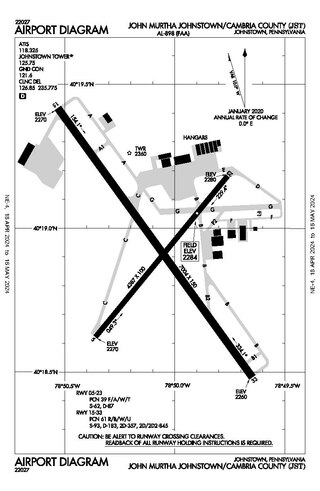
John Murtha Johnstown–Cambria County Airport is a civil-military airport three miles (5 km) northeast of Johnstown, in Cambria County, Pennsylvania. It is owned by Johnstown–Cambria County Airport Authority and is named after the late Congressman John Murtha. It sees one airline, subsidized by the Essential Air Service.

Wrangell Airport is a state-owned public-use airport located one nautical mile (2 km) northeast of the central business district of Wrangell, a city and borough in the U.S. state of Alaska which has no road access to the outside world. Scheduled airline service is subsidized by the Essential Air Service program.
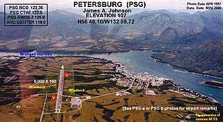
Petersburg James A. Johnson Airport is a state owned, public use airport located one nautical mile (2 km) southeast of the central business district of Petersburg, a city in the Petersburg Borough of the U.S. state of Alaska that has no road access to the outside world. Airline service is subsidized by the Essential Air Service program.

Yakutat Airport is a state-owned public-use airport located three nautical miles (6 km) southeast of the central business district of Yakutat, a city and borough in the U.S. state of Alaska which has no road access to the outside world. Airline service is subsidized by the Essential Air Service program.

Veterans Airport of Southern Illinois , also known as Williamson County Regional Airport, is five miles west of Marion, in Williamson County, Illinois, United States. The airport is owned by the Williamson County Airport Authority. It sees one airline, subsidized by the federal government's Essential Air Service program at an annual cost of $2,562,819 or $141 per passenger. On November 11, 2016 during the grand opening ceremony for the new terminal, the airport was renamed to "Veterans Airport of Southern Illinois" to honor veterans and better reflect the regional nature of the airport.
McKellar–Sipes Regional Airport is a public use airport located four nautical miles (7 km) west of the central business district of Jackson, a city in Madison County, Tennessee, United States. It is owned by the city and county. The airport is mostly used for general aviation, and is served by one commercial airline, Southern Airways Express, subsidized by the Essential Air Service program.

Massena International Airport is in St. Lawrence County, New York. It is two nautical miles (3.7 km) east of the village of Massena. The airport sees one airline, subsidized by the Essential Air Service program.
Kake Seaplane Base is a public-use seaplane base located in Kake, a city in the Petersburg Borough of the U.S. state of Alaska. Scheduled airline passenger service is subsidized by the U.S. Department of Transportation via the Essential Air Service program.


