
Glendalough is a glacial valley in County Wicklow, Ireland, renowned for an Early Medieval monastic settlement founded in the 6th century by St Kevin. From 1825 to 1957, the head of the Glendalough Valley was the site of a galena lead mine. Glendalough is also a recreational area for picnics, for walking along networks of maintained trails of varying difficulty, and also for rock climbing.

Malham Cove is a large curved limestone formation 0.6 miles (1 km) north of the village of Malham, North Yorkshire, England. It was formed by a waterfall carrying meltwater from glaciers at the end of the last Ice Age more than 12,000 years ago. Today it is a well-known beauty spot and rock climbing crag within the Yorkshire Dales National Park. A large limestone pavement lies above the cove.

In geography and geology, a cliff is an area of rock which has a general angle defined by the vertical, or nearly vertical. Cliffs are formed by the processes of weathering and erosion, with the effect of gravity. Cliffs are common on coasts, in mountainous areas, escarpments and along rivers. Cliffs are usually composed of rock that is resistant to weathering and erosion. The sedimentary rocks that are most likely to form cliffs include sandstone, limestone, chalk, and dolomite. Igneous rocks such as granite and basalt also often form cliffs.

Yoho National Park is a national park of Canada. It is located within the Rocky Mountains along the western slope of the Continental Divide of the Americas in southeastern British Columbia, bordered by Kootenay National Park to the south and Banff National Park to the east in Alberta. The word Yoho is a Cree expression of amazement or awe, and it is an apt description for the park's spectacular landscape of massive ice fields and mountain peaks, which rank among the highest in the Canadian Rockies.
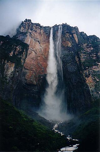
Angel Falls is a waterfall in Venezuela.

Ice climbing is a climbing discipline that involves ascending routes consisting of frozen water. To ascend the route, the ice climber uses specialist equipment, particularly double ice axes and rigid crampons. To protect the route, the ice climber uses steel ice screws that require skill to employ safely and rely on the ice holding firm in any fall. Ice climbing routes can vary significantly by type, and include seasonally frozen waterfalls, high permanently frozen alpine couloirs, and large hanging icicles.

The Montmorency Falls is a large waterfall on the Montmorency River in Quebec, Canada.
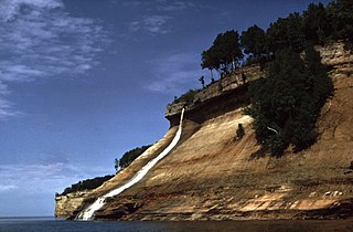
Pictured Rocks National Lakeshore is a U.S. National Lakeshore in the Upper Peninsula of Michigan, United States. It extends for 42 mi (68 km) along the shore of Lake Superior and covers 73,236 acres. The park has extensive views of the hilly shoreline between Munising and Grand Marais in Alger County, with picturesque rock formations, waterfalls, and sand dunes.

Bridal Veil Falls Provincial Park is a BC Park situated on the Trans-Canada Highway just east of Rosedale, British Columbia, Canada, within of the City of Chilliwack. The community of Bridal Falls is located adjacent to the falls and park, as well as the interchange between the Trans-Canada and BC Highway 9, offering a variety of highway-based tourism services. Access to the falls requires a short hike from the parking lot and well-groomed trails, taking most groups 15-25 minutes.

Tettegouche State Park is a Minnesota state park on the north shore of Lake Superior 58 miles (93 km) northeast of Duluth in Lake County on scenic Minnesota Highway 61. The park's name stems from the Tettegouche Club, an association of local businessmen which purchased the park in 1910 from the Alger-Smith Lumber Company. The club's members protected the area until its sale in 1971 to the deLaittres family. In 1979, the state of Minnesota acquired 3,400 acres (1,400 ha) from the Nature Conservancy, including Tettegouche Camp. The land was added to Baptism River State Park, which was renamed Tettegouche State Park.

Shannon Falls Provincial Park is a provincial park in British Columbia, Canada. It is located 58 kilometers (36 mi) from Vancouver and 2 kilometers (1.2 mi) south of Squamish along the Sea to Sky Highway.
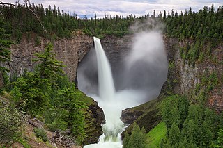
Helmcken Falls is a 141 m (463 ft) waterfall on the Murtle River within Wells Gray Provincial Park in British Columbia, Canada. The protection of Helmcken Falls was one of the reasons for the creation of Wells Gray Provincial Park in 1939.

U-shaped valleys, also called trough valleys or glacial troughs, are formed by the process of glaciation. They are characteristic of mountain glaciation in particular. They have a characteristic U shape in cross-section, with steep, straight sides and a flat or rounded bottom. Glaciated valleys are formed when a glacier travels across and down a slope, carving the valley by the action of scouring. When the ice recedes or thaws, the valley remains, often littered with small boulders that were transported within the ice, called glacial till or glacial erratic.
Johnston Creek is a tributary of the Bow River in Canada's Rocky Mountains. The creek is located in Banff National Park.
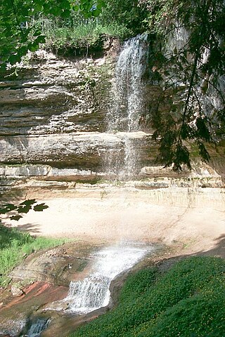
Munising Falls is a waterfall located in Munising in the westernmost portion of the Pictured Rocks National Lakeshore in Alger County, Michigan. The falls drops about 50 feet (15 m) over a sandstone cliff. With the exception of the spring thaw, the amount of water falling is relatively small. There are trails leading to multiple viewpoints around the falls.

Sōunkyō is a range of gorges located in Kamikawa, Hokkaidō, Japan. Situated in the Daisetsuzan National Park, the area is known for its hotels and onsen resorts as well as waterfalls and magnificent cliffs scenery. The term "Sōunkyō" means respectively the layer (層), cloud (雲) and gorge (峡) in Japanese, and the origin of the name is a word "Souunbetsu" in Ainu language, which means "the river with many waterfalls".
Cirque of the Unclimbables, located inside the Nahanni National Park Reserve, in the Northwest Territories, Canada, approximately 500 km (311 mi) west of Yellowknife, is a cluster of peaks and walls in the Mackenzie Mountains Natural Region.

Havasu Creek is a stream in the U.S. state of Arizona associated with the Havasupai people. It is a tributary to the Colorado River, which it enters in the Grand Canyon.
Poke-O-Moonshine Mountain, spelled Pokamoonshine on U.S. Geological Survey maps, and sometimes known as just Poke-O, is a minor peak of the Adirondack Mountains. The name is believed to be a corruption of the Algonquin words pohqui, meaning 'broken', and moosie, meaning 'smooth'. It is located in the town of Chesterfield, New York, United States, on New York state Forest Preserve land, part of the Taylor Pond Wild Forest complex within the Adirondack Park. Due to its location next to the pass through which most travelers from the north enter the range, it has been called the "gateway to the Adirondacks".

Cirrus Mountain is a 3,270-metre (10,730-foot) mountain summit located in the upper North Saskatchewan River valley on the shared boundary between Banff National Park and White Goat Wilderness Area, in the Canadian Rockies of Alberta, Canada. Cirrus Mountain is situated along the east side the Icefields Parkway midway between Saskatchewan Crossing and Sunwapta Pass. Topographic relief is significant as the summit rises 1,740 meters (5,708 ft) above the parkway in 3 km (1.9 mi). The nearest higher peak is Mount Stewart, 5.92 km (3.68 mi) to the north-northeast.


