Weilrod

Last updated
Weilrod
DEU Weilrod Banner.svg
DEU Weilrod COA.svg
Location of Weilrod within Hochtaunuskreis district
Weilrod in HG.svgGlashütten
Germany adm location map.svg
Red pog.svg
Weilrod
Hesse location map.svg
Red pog.svg
Weilrod
Coordinates: 50°20′N8°25′E / 50.333°N 8.417°E / 50.333; 8.417
Country Germany
State Hesse
Admin. region Darmstadt
District Hochtaunuskreis
Government
   Mayor (201723) Götz Esser [1] (FW)
Area
  Total71.16 km2 (27.48 sq mi)
Highest elevation
626 m (2,054 ft)
Lowest elevation
210 m (690 ft)
Population
 (2022-12-31) [2]
  Total6,652
  Density93/km2 (240/sq mi)
Time zone UTC+01:00 (CET)
  Summer (DST) UTC+02:00 (CEST)
Postal codes
61276
Dialling codes 06083, 06084
Vehicle registration HG, USI
Website www.weilrod.de

Weilrod is a municipality made up of several villages in the northwest Hochtaunuskreis lying in the Weil Valley in Hesse, Germany.

Contents

Geography

District Altweilnau as seen from the observation tower on top of the mountain Pferdskopf (Taunus), south of Weilrod DSC07357 Altweilnau aus Richtung Suden gesehen vom Aussichtsturm Pferdskopf.jpg
District Altweilnau as seen from the observation tower on top of the mountain Pferdskopf (Taunus) , south of Weilrod

Location

Weilrod lies north of the crest of the Taunus, from 210 to 600 m above sea level. The nearest bigger towns are Limburg (25 km) in the west, Wetzlar (30 km) in the north, Wiesbaden (35 km) in the south and Frankfurt am Main (35 km) in the southeast.

Neighbouring communities

Weilrod borders in the north on the communities of Weilmünster (Limburg-Weilburg) and Grävenwiesbach, in the east on the town of Usingen, in the south on the communities of Schmitten (all in the Hochtaunuskreis) and Waldems (Rheingau-Taunus-Kreis), and in the west on the town of Bad Camberg and the community of Selters (both in Limburg-Weilburg).

Constituent communities

The community has 13 centres named Altweilnau, Cratzenbach, Emmershausen, Finsternthal, Gemünden, Hasselbach  [ de ], Mauloff, Niederlauken, Neuweilnau, Oberlauken, Rod an der Weil, Riedelbach and Winden.

History

The earliest written record of a village in the area is of Mauloff ("Mulefo") in 1156. The imposing round tower at the castle ruins in Altweilnau has been dated to about 1200.

The merger of the individual communities into the greater community of Weilrod took place in 1972.

Community's name

The name Weilrod stems on the one hand from the river Weil, a brook that forms Weilrod's and neighbouring Schmitten's landscape, and on the other hand from the German word Roden – "clearing".

Both these name stems are also found in constituent communities' names:

The village of Mauloff has a rather interesting name origin, according to the local lore, anyway. Since the name Mauloff does not fit any usual German name pattern, it affords wonderful fodder for legends and quaint stories. One of these stories holds that the village was originally nameless, and that to give it a name, the mayor called a meeting, deciding beforehand that the first word out of anyone's mouth would be the village's new name. Those gathered for the meeting, however, sat there without uttering a word. At last, the mayor ran out of patience and shouted "Maul off!" (roughly "Mouth open!" ie "Say something!", using Maul – more commonly the zoological word for mouth – and off, a variant of auf).

Mauloff had its first documentary mention in 1156 as "Mulefo", a stopping place on the mediaeval road through the heights, the Rennstraße.

Politics

Municipal council

The municipal elections on 26 March 2006 yielded the following results:

SPD 10 seats
CDU 9 seats
FWG8 seats
Greens 3 seats
FDP 1 seat

Note: FWG is a citizens' coalition.

Economy

During the economic boom in the 1950s, the villages that now make up Weilrod were a favourite local recreation area for people who lived in the nearby Frankfurt Rhein-Main Region. Since then, tourism has dropped off noticeably. Nevertheless, the landscape in the municipal area attracts hikers and cyclists, for which a certain amount of credit must go to the Weiltalweg, a trail through the Weil Valley.

The loudspeaker manufacturer Canton Elektronik GmbH was founded in Weilrod and still has its headquarters there. Other companies in the community are Mania (tool technology), Grünauer Maschinen GmbH and AZ (Armaturen-Zimmermann, founded in Hasselbach).

Related Research Articles

The Hochtaunuskreis is a Kreis (district) in the middle of Hesse, Germany and is part of the Frankfurt/Rhine-Main Metropolitan Region. Neighbouring districts are Lahn-Dill, Wetteraukreis, district-free Frankfurt, Main-Taunus, Rheingau-Taunus, Limburg-Weilburg.

Rheingau-Taunus is a Kreis (district) in the west of Hesse, Germany. Rheingau-Taunus-Kreis is part of the Darmstadt region; its main administrative seat is Bad Schwalbach. Outposted sections of the local administration are located in Idstein and Rüdesheim am Rhein.

Limburg-Weilburg is a Kreis (district) in the west of Hesse, Germany. Neighboring districts are Lahn-Dill, Hochtaunuskreis, Rheingau-Taunus, Rhein-Lahn, Westerwaldkreis.

<span class="mw-page-title-main">Oberursel (Taunus)</span> Town in Hesse, Germany

Oberursel (Taunus) (German:[oː.bɐ.ˈʊʁ.zl̩] ) is a town in Germany and part of the Frankfurt Rhein-Main urban area. It is located to the north west of Frankfurt, in the Hochtaunuskreis county. It is the 13th largest town in Hesse. In 2011, the town hosted the 51st Hessentag state festival.

<span class="mw-page-title-main">Neu-Anspach</span> Town in Hesse, Germany

Neu-Anspach is a town in the Hochtaunuskreis in Hesse, Germany.

<span class="mw-page-title-main">Usingen</span> Town in Hesse, Germany

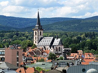
Usingen is a small town in the Hochtaunuskreis in Hessen, Germany. Until 1972, this residential and school town was the seat of the former district of Usingen.

<span class="mw-page-title-main">Schmitten im Taunus</span> Municipality in Hesse, Germany

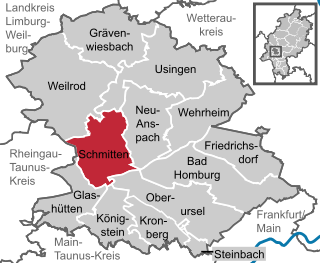
Schmitten im Taunus is a municipality in the Hochtaunuskreis in Hessen, Germany.

<span class="mw-page-title-main">Leun</span> Town in Hesse, Germany

Leun is a small town in the Lahn-Dill-Kreis in Hesse, Germany.

<span class="mw-page-title-main">Selters (Taunus)</span> Municipality in Hesse, Germany

Selters (Taunus) is a municipality with 8,000 inhabitants north of Bad Camberg in Limburg-Weilburg district in Hesse, Germany.

<span class="mw-page-title-main">Grävenwiesbach</span> Municipality in Hesse, Germany

Grävenwiesbach is a municipality in the Hochtaunuskreis in Hesse, Germany.

<span class="mw-page-title-main">Wehrheim</span> Municipality in Hesse, Germany

Wehrheim is a municipality in Hesse, Germany some 30 km (20 mi) north of Frankfurt am Main.

<span class="mw-page-title-main">Bad Camberg</span> Town in Hesse, Germany

Bad Camberg is, with 14,200 inhabitants, the second largest town in Limburg-Weilburg district in Hesse, Germany, as well as the southernmost town in the Regierungsbezirk of Gießen. It is located in the eastern Taunus in the Goldener Grund some 30 km north of Wiesbaden, 18 km southeast of Limburg an der Lahn, and 44 km northwest of Frankfurt, as well as on the German Timber-Frame Road. Bad Camberg is the central community of the Goldener Grund with good infrastructure, and a lower centre partly with a middle centre's function.

<span class="mw-page-title-main">Hünfelden</span> Municipality in Hesse, Germany

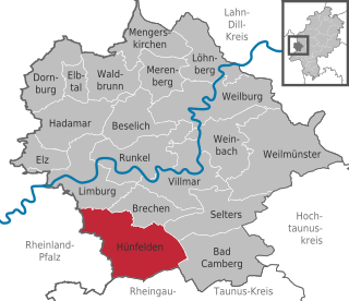
Hünfelden is a municipality in Limburg-Weilburg district in Hesse, Germany. Hünfelden lies on the Hühnerstraße, an historic part of Bundesstraße 417.

<span class="mw-page-title-main">Waldsolms</span> Municipality in Hesse, Germany

Waldsolms is a municipality located in the Lahn-Dill-Kreis in Hesse, Germany.

<span class="mw-page-title-main">Glashütten (Taunus)</span> Municipality in Hesse, Germany

Glashütten is a small municipality in the Hochtaunuskreis. This community in the Taunus, which is made up of the three formerly independent communities of Glashütten, Schloßborn and Oberems, lies in the Hochtaunus Nature Park, not far from Königstein im Taunus, Germany.

<span class="mw-page-title-main">Weilmünster</span> Municipality in Hesse, Germany

Weilmünster is a municipality in Limburg-Weilburg district in Hesse, Germany.

<span class="mw-page-title-main">Mengerskirchen</span> Municipality in Hesse, Germany

Mengerskirchen is a municipality in Limburg-Weilburg district in Hesse, Germany.

<span class="mw-page-title-main">Waldems</span> Municipality in Hesse, Germany

Waldems is a municipality in the Rheingau-Taunus-Kreis in the Regierungsbezirk of Darmstadt in Hesse, Germany. The municipality's administrative seat is Waldems-Esch.

<span class="mw-page-title-main">Weil (river)</span> River in Germany

The Weil is 46.6-kilometre-long (29.0 mi) river in Hesse, Germany. It is a left tributary to the Lahn river and the town of Weilburg is located next to its mouth. The river flows exclusively through the Taunus mountain range with its source being located between the Kleiner Feldberg and Großer Feldberg mountains. It flows through Schmitten, Weilrod and Weilmünster. A hiking trail as well as a biking trail follow the course of the river.

<span class="mw-page-title-main">Taunus Nature Park</span>

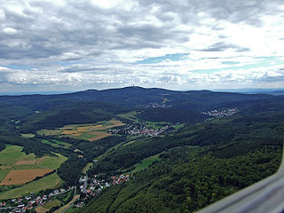
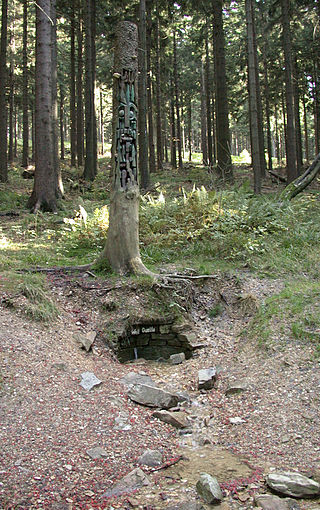
The Taunus Nature Park is a nature park in Central Germany with an area of 134,775 hectares (1347.75 km2) in the Central Upland range of the Taunus. It is one of two Hessian nature parks in the Taunus and the second largest nature park in Hesse.

References

  1. "Ergebnisse der letzten Direktwahl aller hessischen Landkreise und Gemeinden" (XLS) (in German). Hessisches Statistisches Landesamt. 5 September 2022.
  2. "Bevölkerung in Hessen am 31.12.2022 nach Gemeinden" (XLS) (in German). Hessisches Statistisches Landesamt. June 2023.