The New York Central Railroad was a railroad primarily operating in the Great Lakes and Mid-Atlantic regions of the United States. The railroad primarily connected greater New York and Boston in the east with Chicago and St. Louis in the Midwest, along with the intermediate cities of Albany, Buffalo, Cleveland, Cincinnati, Detroit, Rochester and Syracuse. New York Central was headquartered in New York City's New York Central Building, adjacent to its largest station, Grand Central Terminal.

The Merchandise Mart is a commercial building located in downtown Chicago, Illinois. When it was opened in 1930, it was the largest building in the world, with 4 million square feet (372,000 m2) of floor space. The Art Deco structure is located at the junction of the Chicago River's branches. The building is a leading retailing and wholesale location, hosting 20,000 visitors and tenants per day in the late 2000s.

The Galena and Chicago Union Railroad (G&CU) was a railroad running west from Chicago to Freeport, Illinois, never reaching Galena, Illinois. A later route went to Clinton, Iowa. Incorporated in 1836, the G&CU became the first railroad built out from Chicago.

The Brown Line of the Chicago "L" system, is an 11.4-mile (18.3 km) route with 27 stations between Chicago's Albany Park neighborhood and downtown Chicago. It runs completely above ground and is almost entirely grade-separated. It is the third-busiest 'L' route, with an average of 28,315 passengers boarding each weekday in 2022.

The Illinois Central Railroad, sometimes called the Main Line of Mid-America, was a railroad in the Central United States, with its primary routes connecting Chicago, Illinois, with New Orleans, Louisiana, and Mobile, Alabama, and thus, the Great Lakes to the Gulf of Mexico. A line also connected Chicago west to Sioux City, Iowa (1870). There was a significant branch to Omaha, Nebraska (1899), west of Fort Dodge, Iowa, and another branch reaching Sioux Falls, South Dakota (1877), starting from Cherokee, Iowa. The IC also serviced Miami, Florida, on trackage owned by other railroads

For the purposes of this article, the Jersey City area extends North to Edgewater, South to Bayonne and includes Kearny Junction and Harrison but not Newark. Many routes east of Newark are listed here.

The Boston and Albany Railroad was a railroad connecting Boston, Massachusetts to Albany, New York, later becoming part of the New York Central Railroad system, Conrail, and CSX Transportation. The line is currently used by CSX for freight. Passenger service is provided on the line by Amtrak, as part of their Lake Shore Limited service, and by the MBTA Commuter Rail system, which owns the section east of Worcester and operates it as its Framingham/Worcester Line.

The Fitchburg Railroad is a former railroad company, which built a railroad line across northern Massachusetts, United States, leading to and through the Hoosac Tunnel. The Fitchburg was leased to the Boston and Maine Railroad in 1900. The main line from Boston to Fitchburg is now operated as the MBTA Fitchburg Line; Pan Am Railways runs freight service on some other portions.

The Chicago North Shore and Milwaukee Railroad, also known as the North Shore Line, was an interurban railroad that operated passenger and freight service over an 88.9-mile (143.1 km) route between the Chicago Loop and downtown Milwaukee, as well as an 8.6-mile (13.8 km) branch line between the villages of Lake Bluff and Mundelein, Illinois. The North Shore Line also provided streetcar, city bus and motor coach services along its interurban route.
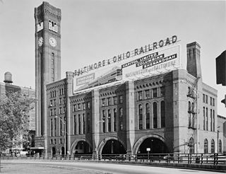
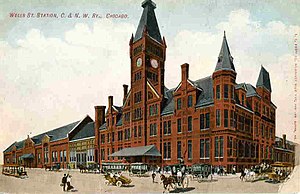
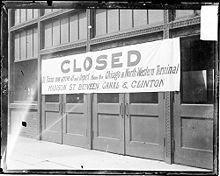
Grand Central Station was a passenger railroad terminal in downtown Chicago, Illinois, from 1890 to 1969. It was located at 201 West Harrison Street on a block bounded by Harrison, Wells and Polk Streets and the Chicago River in the southwestern portion of the Chicago Loop. Grand Central Station was designed by architect Solon Spencer Beman for the Wisconsin Central Railroad (WC), and was completed by the Chicago and Northern Pacific Railroad.
The St. Charles Air Line is a rail line in Chicago, Illinois, partially owned by the BNSF Railway, Union Pacific Railroad, and Canadian National Railway.

The Illinois Terminal Railroad Company, known as the Illinois Traction System until 1937, was a heavy duty interurban electric railroad with extensive passenger and freight business in central and southern Illinois from 1896 to 1956. When Depression era Illinois Traction was in financial distress and had to reorganize, the Illinois Terminal name was adopted to reflect the line's primary money making role as a freight interchange link to major steam railroads at its terminal ends, Peoria, Danville, and St. Louis. Interurban passenger service slowly was reduced, ending in 1956. Freight operation continued but was hobbled by tight street running in some towns requiring very sharp radius turns. In 1956, ITC was absorbed by a consortium of connecting railroads.

The Sacramento Northern Railway was a 183-mile (295 km) electric interurban railway that connected Chico in northern California with Oakland via the California capital, Sacramento. In its operation it ran directly on the streets of Oakland, Sacramento, Yuba City, Chico, and Woodland and ran interurban passenger service until 1941 and freight service into the 1960s.

Merchandise Mart is a station on the Chicago Transit Authority's 'L' system, located in the Near North Side neighborhood at 350 North Wells Street in Chicago, Illinois. The station is elevated above street level, on a steel structure. The turnstiles and customer assistant booth of the station are located on the second level of the Merchandise Mart itself. This is the main entrance to the station.

Forest Park is a station on the Chicago Transit Authority's 'L' system, located in the village of Forest Park, Illinois and serving the Blue Line. Before the Congress Line was built, it served as terminal for the Garfield Line. It is the western terminus of the Forest Park branch. The station was known as Des Plaines until 1994. It is also referred to as the Forest Park Transit Center by Pace because it is a major terminal for Pace buses. The station contains a 1,051-space Park and Ride lot which uses the "Pay and Display" system, in which fees are paid at the lot entrance. It is located south of the Baltimore and Ohio Chicago Terminal Railroad tracks which curve to the north of the station towards Madison Street where the line rechristens itself to the Canadian National Railway's Waukesha Subdivision.
The Galena and Southern Wisconsin Railroad Company (G&SWRR) existed as a functioning 3 ft narrow gauge railroad from 1874 to 1880, when it was ultimately bought by the Chicago and North Western Railway (C&NW) after a series of short ownership and name changes. Originally it had connections between Galena, Illinois and Platteville, Wisconsin, with later additions reaching up to Monfort Junction, Wisconsin, near Montfort, Wisconsin, where it ran west to Fennimore, WI, and connected to the Chicago and Tomah Railroad.

The Chicago and North Western Railway's Kinzie Street railroad bridge is a single leaf bascule bridge across the north branch of the Chicago River in downtown Chicago, Illinois. At the time of its opening in 1908 it was the world's longest and heaviest bascule bridge. The previous bridges on the same site included a pedestrian span that was the first bridge across the Chicago River; a second bridge that served as Chicago's first railroad bridge; and a third bridge that was one of the first all-steel spans in the United States.
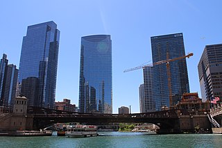
Wolf Point is the location at the confluence of the North, South and Main Branches of the Chicago River in the present day Near North Side, Loop, and Near West Side community areas of Chicago. This fork in the river is historically important in the development of early Chicago. Located about 1.6 miles (2.6 km) from Lake Michigan, this was the location of Chicago's first three taverns, its first hotel, Sauganash Hotel, its first ferry, its first drug store, its first church, its first theater company, and the first bridges across the Chicago River. The name is said to possibly derive from a Native American Chief whose name translated to wolf, but alternate theories exist.

DeKalb station is a former railway station in Downtown DeKalb, Illinois. It served passenger trains of the Chicago and North Western Railway (C&NW) along its main line between Chicago and Omaha. The station was designed by Charles Sumner Frost and Alfred Hoyt Granger in 1891 and closed for passenger service in 1971. The building still stands and is used by the Union Pacific Railroad for offices.