West, Mississippi

Last updated

West, Mississippi
Holmes County Mississippi Incorporated and Unincorporated areas West Highlighted.svg
Location of West, Mississippi
Usa edcp location map.svg
Red pog.svg
West, Mississippi
Location in the United States
Coordinates: 33°11′49″N89°46′38″W / 33.19694°N 89.77722°W / 33.19694; -89.77722
Country United States
State Mississippi
County Holmes
Government
  MayorMichael Fancher
Area
[1]
  Total0.56 sq mi (1.44 km2)
  Land0.56 sq mi (1.44 km2)
  Water0.00 sq mi (0.00 km2)
Elevation
292 ft (89 m)
Population
 (2020)
  Total153
  Density274.19/sq mi (105.96/km2)
Time zone UTC-6 (Central (CST))
  Summer (DST) UTC-5 (CDT)
ZIP code
39192
Area code 662
FIPS code 28-78680
GNIS feature ID679466 [2]

West is a town in northeastern Holmes County, Mississippi, United States. [2] Per the 2020 census, the population was 153. [3] The Mayor of West, MS as of December 2020 is Michael Fancher. [4]

Contents

History

West made national news in 1989 when all-white East Holmes Academy, now closed but formerly located in West, initially refused to play a football game against Heritage Academy because Heritage had a black player. After seven East Holmes players quit the team, two board members resigned and the Mississippi Private School Association threatened to eject the school, East Holmes relented. [5]

Geography

West is bordered to the east by the Big Black River, which is also the Attala County line. West is the easternmost municipality in Holmes county.

U.S. Route 51 passes through the center of town, leading north 10 miles (16 km) to Vaiden and south 9 miles (14 km) to Durant. Interstate 55 passes 3 miles (5 km) west of town, with access from Exit 164 (Emory Road). I-55 leads south 70 miles (110 km) to Jackson, the state capital, and north 140 miles (230 km) to Memphis, Tennessee. Mississippi Highway 19 leads 17 miles (27 km) southeast from West to Kosciusko.

According to the United States Census Bureau, the town of West has a total area of 0.54 square miles (1.4 km2), all land. [6]

Demographics

Historical population
CensusPop.Note
1880 200
1900 196
1910 27640.8%
1920 236−14.5%
1930 37056.8%
1940 4028.6%
1950 354−11.9%
1960 282−20.3%
1970 3058.2%
1980 253−17.0%
1990 184−27.3%
2000 22019.6%
2010 185−15.9%
2020 153−17.3%
U.S. Decennial Census [7]
2010 [8] 2020 [9]

2020 census

West town, Mississippi – Demographic Profile
(NH = Non-Hispanic)
Race / EthnicityPop 2010 [8] Pop 2020 [9] % 2010% 2020
White alone (NH)888047.47%52.29%
Black or African American alone (NH)976852.43%44.44%
Native American or Alaska Native alone (NH)000.00%0.00%
Asian alone (NH)020.00%1.31%
Pacific Islander alone (NH)000.00%0.00%
Some Other Race alone (NH)000.00%0.00%
Mixed Race/Multi-Racial (NH)020.00%1.31%
Hispanic or Latino (any race)010.00%0.65%
Total185153100.00%100.00%

Note: the US Census treats Hispanic/Latino as an ethnic category. This table excludes Latinos from the racial categories and assigns them to a separate category. Hispanics/Latinos can be of any race.

2000 Census

As of the census [10] of 2000, there were 220 people, 94 households, and 64 families residing in the town. The population density was 394.6 inhabitants per square mile (152.4/km2). There were 113 housing units at an average density of 202.7 per square mile (78.3/km2). The racial makeup of the town was 56.36% White, 42.73% African American, 0.45% Asian, and 0.45% from two or more races. Hispanic or Latino of any race were 2.27% of the population.

There were 94 households, out of which 26.6% had children under the age of 18 living with them, 54.3% were married couples living together, 13.8% had a female householder with no husband present, and 30.9% were non-families. 29.8% of all households were made up of individuals, and 20.2% had someone living alone who was 65 years of age or older. The average household size was 2.34 and the average family size was 2.88.

In the town, the population was spread out, with 22.7% under the age of 18, 7.7% from 18 to 24, 25.9% from 25 to 44, 18.6% from 45 to 64, and 25.0% who were 65 years of age or older. The median age was 40 years. For every 100 females, there were 91.3 males. For every 100 females age 18 and over, there were 88.9 males.

The median income for a household in the town was $25,625, and the median income for a family was $45,625. Males had a median income of $22,083 versus $12,396 for females. The per capita income for the town was $18,398. About 14.9% of families and 20.9% of the population were below the poverty line, including 20.9% of those under the age of eighteen and 31.2% of those 65 or over.

Education

The town of West is served by the Holmes County School District.

Related Research Articles

<span class="mw-page-title-main">Anthonyville, Arkansas</span> Town in Arkansas, United States

Anthonyville is a town in Crittenden County, Arkansas, United States. The population was 161 at the 2010 census, down from 250 in 2000.

<span class="mw-page-title-main">Edmondson, Arkansas</span> Town in Arkansas, United States

Edmondson is a town in Crittenden County, Arkansas, United States. The population was 427 at the 2010 census.

<span class="mw-page-title-main">Esto, Florida</span> Town in Florida, United States

Esto is a town in Holmes County, Florida, United States. The Town of Esto is located on the Florida Panhandle in North Florida. The population was 341 at the 2020 census.

<span class="mw-page-title-main">Ponce de Leon, Florida</span> Town in the state of Florida, United States

Ponce de Leon is a town in Holmes County, Florida, United States. The Town of Ponce de Leon was named after Spanish explorer, Juan Ponce de León. It is part of the Florida Panhandle in North Florida. The population was 504 at the 2020 census, down from 598 at the 2010 census.

<span class="mw-page-title-main">Westville, Florida</span> Town in the state of Florida, United States

Westville is a town in Holmes County, Florida, United States. Westville is part of the Florida Panhandle in North Florida. As of the 2020 census, the town had a population of 261, down from 289 at the 2010 census. From 2010 to 2020, Westville's population growth percentage was -9.7%.

<span class="mw-page-title-main">Madison, Illinois</span> City in Illinois, United States

Madison is a city in Madison and St. Clair counties in the U.S. state of Illinois. The population was 3,171 at the 2020 census, down from 3,891 in 2010. It is home to World Wide Technology Raceway at Gateway and the first Bulgarian Orthodox church in the United States.

<span class="mw-page-title-main">Venice, Illinois</span> City in Illinois, United States

Venice is a city in Madison County, Illinois, United States. The population was 1,498 at the 2020 census, down from 1,890 in 2010.

<span class="mw-page-title-main">Gunnison, Mississippi</span> Town in Mississippi, United States

Gunnison is a town in Bolivar County, Mississippi, United States. Per the 2020 census, the population was 295.

<span class="mw-page-title-main">Merigold, Mississippi</span> Town in Mississippi, United States

Merigold is a town in Bolivar County, Mississippi, United States. Per the 2020 census, the population was 379.

<span class="mw-page-title-main">Pace, Mississippi</span> Town in Mississippi, United States

Pace is a town in Bolivar County, Mississippi, United States. Per the 2020 census, the population was 183.

<span class="mw-page-title-main">Renova, Mississippi</span> Town in Mississippi, United States

Renova is a town in Bolivar County, Mississippi, United States.Per the 2020 census, the population was 676. The community was founded by African Americans and remains predominantly African American.

<span class="mw-page-title-main">Coahoma, Mississippi</span> Town in Mississippi, United States

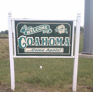
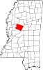
Coahoma is a town in Coahoma County, Mississippi, United States. Per the 2020 census, the population was 229.

<span class="mw-page-title-main">Beauregard, Mississippi</span> Village in Mississippi, United States

Beauregard is a village in Copiah County, Mississippi, United States. The population was 326 at the 2010 census. It is part of the Jackson Metropolitan Statistical Area. Beauregard is named for P. G. T. Beauregard.

<span class="mw-page-title-main">Cruger, Mississippi</span> Town in Mississippi, United States

Cruger is a town in Holmes County, Mississippi, United States. Per the 2020 census, the population was 268.

<span class="mw-page-title-main">Goodman, Mississippi</span> Town in Mississippi, United States

Goodman is a town in southeastern Holmes County, Mississippi, United States. Per the 2020 census, the population was 1,258.

<span class="mw-page-title-main">Pickens, Mississippi</span> Town in Mississippi, United States

Pickens is a town in Holmes County, Mississippi, United States. Per the 2020 census, the population was 920.

<span class="mw-page-title-main">Falcon, Mississippi</span> Town in Mississippi, United States

Falcon is a town in Quitman County, Mississippi. The population was 116 at the 2020 census.

<span class="mw-page-title-main">Sledge, Mississippi</span> Town in Mississippi, United States

Sledge is a town located in Quitman County, Mississippi, United States. As of the 2020 census, the town had a total population of 368.

<span class="mw-page-title-main">Bentonia, Mississippi</span> Town in Mississippi, United States

Bentonia is a town in Yazoo County, Mississippi, United States. The population as of the 2020 census was 319.

<span class="mw-page-title-main">Lula, Mississippi</span> Town in Mississippi, United States

Lula is a town in Coahoma County, Mississippi, United States. Per the 2020 census, the population was 204.

References

  1. "2020 U.S. Gazetteer Files". United States Census Bureau. Retrieved July 24, 2022.
  2. 1 2 U.S. Geological Survey Geographic Names Information System: West
  3. "West town, Mississippi". United States Census Bureau . Retrieved April 15, 2022.
  4. holmescounty (December 13, 2017). "Municipalities". holmescountyms.org. Retrieved December 30, 2020.
  5. Weingarten, Paul (October 20, 1989). "A Goal-line Stand For Prejudice". The Chicago Tribune. Retrieved October 21, 2014.
  6. "Geographic Identifiers: 2010 Census Summary File 1 (G001): West town, Mississippi". American Factfinder. U.S. Census Bureau. Archived from the original on February 13, 2020. Retrieved August 18, 2017.
  7. "Decennial Census of Population and Housing by Decades". US Census Bureau.
  8. 1 2 "P2 HISPANIC OR LATINO, AND NOT HISPANIC OR LATINO BY RACE – 2010: DEC Redistricting Data (PL 94-171) – West town, Mississippi". United States Census Bureau .
  9. 1 2 "P2 HISPANIC OR LATINO, AND NOT HISPANIC OR LATINO BY RACE – 2020: DEC Redistricting Data (PL 94-171) – West town, Mississippi". United States Census Bureau .
  10. "U.S. Census website". United States Census Bureau . Retrieved January 31, 2008.