
The Bahamas, known officially as the Commonwealth of The Bahamas, is a country within the Lucayan Archipelago of the West Indies in the Atlantic. It takes up 97% of the Lucayan Archipelago's land area and is home to 88% of the archipelago's population. The archipelagic state consists of more than 700 islands, cays, and islets in the Atlantic Ocean, and is located north of Cuba and northwest of the island of Hispaniola and the Turks and Caicos Islands, southeast of the American state of Florida, and east of the Florida Keys. The capital is Nassau on the island of New Providence. The Royal Bahamas Defence Force describes The Bahamas' territory as encompassing 470,000 km2 (180,000 sq mi) of ocean space.

The economy of the Bahamas is dependent upon tourism and offshore banking. The Bahamas is the richest country in the West Indies and is ranked 14th in North America for nominal GDP. It is a stable, developing nation in the Lucayan Archipelago, with a population of 391,232 (2016). Steady growth in tourism receipts and a boom in construction of new hotels, resorts, and residences had led to solid GDP growth for many years. The slowdown in the Economy of the United States and the September 11 attacks held back growth in these sectors from 2001 to 2003.
This article talks about transportation in the Bahamas, a North American archipelagic state in the Atlantic Ocean.
The Lucayanpeople were the original residents of the Bahamas before the European conquest of the Americas. They were a branch of the Tainos who inhabited most of the Caribbean islands at the time. The Lucayans were the first indigenous Americans encountered by Christopher Columbus. Shortly after contact, the Spanish kidnapped and enslaved Lucayans, with the genocide culminating in complete eradication of Lucayan people from the Bahamas by 1520.

Andros Island is an archipelago within the Bahamas, the largest of the Bahamian Islands. Politically considered a single island, Andros in total has an area greater than all the other 700 Bahamian islands combined. The land area of Andros consists of hundreds of small islets and cays connected by mangrove estuaries and tidal swamplands, together with three major islands: North Andros, Mangrove Cay, and South Andros. The three main islands are separated by "bights", estuaries that trifurcate the island, connecting the island's east and west coasts. It is 167 kilometres (104 mi) long by 64 km (40 mi) wide at the widest point.

The Abaco Islands lie in the northern Bahamas, 180 miles off the South Florida coast. They comprise the main islands of Great Abaco and Little Abaco, along with smaller barrier cays. The northernmost are Walker's Cay, and its sister island Grand Cay. To the south, the next inhabited islands are Spanish Cay and Green Turtle Cay, with its settlement of New Plymouth, Great Guana Cay, private Scotland Cay, Man-O-War Cay, and Elbow Cay, with its settlement of Hope Town. Southernmost are Tilloo Cay and Lubbers Quarters. Another of note off Abaco's western shore is onetime Gorda Cay, now a Disney Island and cruise ship stop and renamed Castaway Cay. Also in the vicinity is Moore's Island. On the Big Island of Abaco is Marsh Harbour, the Abacos' commercial hub and the Bahamas' third largest city, plus the resort area of Treasure Cay. Both have airports. A few mainland settlements of significance are Coopers Town and Fox Town in the north and Cherokee and Sandy Point in the south. Administratively, the Abaco Islands constitute seven of the 31 Local Government Districts of the Bahamas: Grand Cay, North Abaco, Green Turtle Cay, Central Abaco, South Abaco, Moore's Island, and Hope Town.

Grand Bahama is the northernmost of the islands of the Bahamas, with the town of West End located 56 nautical miles east of Palm Beach, Florida. It is the third largest island in the Bahamas island chain of approximately 700 islands and 2,400 cays. The island is roughly 530 square miles (1,400 km2) in area and approximately 153 kilometres (95 mi) long west to east and 24 kilometres (15 mi) at its widest point north to south. Administratively, the island consists of the Freeport Bonded Area and the districts of East Grand Bahama and West Grand Bahama. Nearly half of the homes on the island were damaged or destroyed in early September 2019 by Hurricane Dorian.

Freeport is a city, district and free trade zone on the island of Grand Bahama of the northwest Bahamas. In 1955, Wallace Groves, a Virginian financier with lumber interests in Grand Bahama, was granted 20,000 hectares of pineyard with substantial areas of swamp and scrubland by the Bahamian government with a mandate to economically develop the area. Freeport has grown to become the second most populous city in the Bahamas.

Exuma is a district of The Bahamas, consisting of over 365 islands, also called cays.

Mayaguana is the easternmost island and district of the Bahamas. Its population was 277 in the 2010 census. It has an area of about 280 km2 (110 sq mi).

West Grand Bahama is one of 31 districts of The Bahamas. The district covers the entire western portion of Grand Bahama island, excluding the city of Freeport, which forms its own district. Communities within West Grand Bahama include the settlements of Mack Town, Hunters, Lewis Yard, Pinder's Point, Eight Mile Rock, Hepburn Town, Bartlett Hill, Hanna Hill, Pine Dale, Martin Town, Russell Town, Jones Town, Sea Grape, Holmes Rock, Bootle Bay and the westernmost settlement of West End.

Grand Bahama International Airport (GBIA) is a privately owned international airport in Freeport, Bahamas.

The effects of Hurricane Wilma in The Bahamas were generally unexpected and primarily concentrated on the western portion of Grand Bahama. Hurricane Wilma developed on October 15, 2005 in the Caribbean, and after initially organizing slowly it explosively deepened to reach peak winds of 185 mph (295 km/h) and a record-low pressure of 882 mbar (hPa). It weakened and struck eastern Mexico as a Category 4 hurricane on the Saffir–Simpson scale, and accelerated northeastward to make landfall on southwestern Florida on October 24. After crossing the state, Wilma briefly restrengthened in the open Atlantic Ocean, moving north of The Bahamas before weakening and later becoming an extratropical cyclone.
The following outline is provided as an overview of and topical guide to The Bahamas:

Walker's Cay is the northernmost island in the Bahamas, part of the North Abaco district. Once a popular sport fishing location, the island has been deserted since 2004, following severe hurricane damage. The island is currently undergoing renovation under new ownership.

The following is an alphabetical list of topics related to the Commonwealth of The Bahamas.
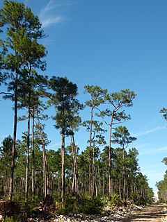
The Bahamian pineyards are a tropical and subtropical coniferous forest ecoregion in the Bahamas and the Turks and Caicos Islands.

Long Island is an island in the Bahamas that is split by the Tropic of Cancer. It is one of the Districts of the Bahamas and is known as the most scenic island in the Bahamas. Its capital is Clarence Town. The population of Long Island is 3,094 inhabitants.
Wallace Groves was a prominent financier, who, after his release from federal prison in 1944, moved to the Bahamas and there founded and operated the free trade zone, resort, and casino development Freeport on Grand Bahama Island. Investigators of U.S. organized crime associate him with the Meyer Lansky syndicate operating offshore casinos from Miami Beach. These ties notwithstanding, he is credited with being a driving force in the development of the modern Bahamian economy.
Bahamian cuisine refers to the foods and beverages of The Bahamas. It includes seafood such as fish, shellfish, lobster, crab, and conch, as well as tropical fruits, rice, peas, pigeon peas, and pork. Popular seasonings commonly used in dishes include chilies, lime, tomatoes, onions, garlic, allspice, cinnamon, rum, and coconut. Rum-based beverages are popular on the islands. Since the Bahamas consist of a multitude of islands, notable culinary variations exist.

