
Columbus is the state capital and the most populous city in the U.S. state of Ohio. With a 2020 census population of 905,748, it is the 14th-most populous city in the U.S., the second-most populous city in the Midwest, after Chicago, and the third-most populous state capital. Columbus is the county seat of Franklin County; it also extends into Delaware and Fairfield counties. It is the core city of the Columbus metropolitan area, which encompasses ten counties in central Ohio. The metropolitan area had a population of 2,138,926 in 2020, making it the largest entirely in Ohio and 32nd-largest in the U.S.

Ohio is a state in the Midwestern region of the United States. Of the fifty U.S. states, it is the 34th-largest by area, and with a population of nearly 11.8 million, is the seventh-most populous and tenth-most densely populated. The state's capital and largest city is Columbus, with the Columbus metro area, Greater Cincinnati, and Greater Cleveland being the largest metropolitan areas. Ohio is bordered by Lake Erie to the north, Pennsylvania to the east, West Virginia to the southeast, Kentucky to the southwest, Indiana to the west, and Michigan to the northwest. Ohio is historically known as the "Buckeye State" after its Ohio buckeye trees, and Ohioans are also known as "Buckeyes". Its state flag is the only non-rectangular flag of all the U.S. states.
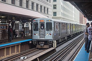
The Orange Line is a rapid transit line in Chicago, Illinois, operated by the Chicago Transit Authority as part of the Chicago "L" system. It is approximately 13 miles (21 km) long and runs on elevated and at grade tracks and serves the Southwest Side, running from the Loop to Midway International Airport. As of 2019, an average of 27,230 riders board Orange Line trains on weekdays.

The Orange Line is a rapid transit line of the Washington Metro system, consisting of 26 stations in Fairfax County and Arlington, Virginia; the District of Columbia; and Prince George's County, Maryland, United States. The Orange Line runs from Vienna in Virginia to New Carrollton in Maryland. Half of the line's stations are shared with the Blue Line and over two thirds are shared with the Silver Line. Orange Line service began on November 20, 1978.

State Road 528 (SR 528), alternatively named the Martin Andersen Beachline Expressway, is a partially-tolled state road in the U.S. state of Florida; it is maintained by the Florida's Turnpike Enterprise (FTE), the Central Florida Expressway Authority (CFX), and the Florida Department of Transportation (FDOT). Spanning approximately 53 miles (85 km) along a west–east axis, it connects Interstate 4 (I-4) in Orlando with I-95, Titusville, and Cape Canaveral on the Space Coast. It passes close to the tourist areas of Orlando, including SeaWorld and Universal Orlando, and serves the north entrance to Orlando International Airport. Near its east end, it passes over the Intracoastal Waterway on the Emory L. Bennett Causeway, and ends at SR A1A and SR 401 near Port Canaveral.

The Little Miami Scenic Trail is the fourth longest paved trail in the United States, running 78.1 miles (125.7 km) through five southwestern counties in the state of Ohio. The multi-use rail trail sees heavy recreational use by hikers and bicyclists, as well as the occasional horseback rider. Over 700,000 people made use of the trail in 2014.

Interstate 280 (I-280) is a 17.85-mile (28.73 km) Interstate Highway in the US state of New Jersey. It provides a spur from I-80 in Parsippany–Troy Hills, Morris County, east to Newark and I-95 in Kearny, Hudson County. In Kearny, access is provided toward the Holland Tunnel and Lincoln Tunnel to New York City. The western part of the route runs through suburban areas of Morris and Essex counties, crossing the Watchung Mountains. Upon reaching The Oranges, the setting becomes more urbanized and I-280 runs along a depressed alignment before ascending again in Newark. I-280 includes a vertical-lift bridge, the William A. Stickel Memorial Bridge, over the Passaic River between Newark and East Newark/Harrison. The highway is sometimes called the Essex Freeway. I-280 interchanges with several roads, including the Garden State Parkway in East Orange and Route 21 in Newark.

A diverging diamond interchange (DDI), also called a double crossover diamond interchange (DCD), is a subset of diamond interchange in which the opposing directions of travel on the non-freeway road cross each other on either side of the interchange so that traffic crossing the freeway on the overpass or underpass is operating on the opposite driving side from that which is customary for the jurisdiction. The crossovers may employ one-side overpasses or be at-grade and controlled by traffic light.

The London Borough of Hammersmith & Fulham, an Inner London borough, has 231 hectares of parks and open spaces that are accessible to the general public, 159 hectares being within parks and 52.5 hectares within cemeteries and churchyards. Wormwood Scrubs and Scrubs Wood, located in the north of the Borough account for 42 hectares and Fulham Palace and Bishop's Park grounds contain another 14 hectares of open space. Private open space includes Hurlingham, Fulham and Queen's Club in West Kensington.
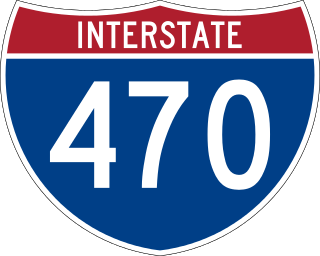
Interstate 470 (I-470) is a 10.63-mile-long (17.11 km) auxiliary Interstate Highway of I-70 that bypasses the city of Wheeling, West Virginia, in the US. I-470 is one of 13 auxiliary Interstate Highways in Ohio and the only auxiliary Interstate Highway in West Virginia. The western terminus of I-470 is an interchange with I-70 in Richland Township, Ohio. Traveling southeast through rural Belmont County, I-470 approaches the Vietnam Veterans Memorial Bridge, which spans the Ohio River. After crossing the river into Ohio County, West Virginia, the highway turns east toward the Wheeling communities of Bethlehem and Elm Grove and its eastern terminus at I-70 near Elm Grove. The portion of the highway in West Virginia is named the USS West Virginia Memorial Highway by proclamation of then-Governor Cecil H. Underwood on the 59th anniversary of the attack on Pearl Harbor.

State Road 46 is an east–west route in central Florida, running from U.S. Route 441 in Mount Dora to US 1 in Mims. Along the way, it crosses the Wekiva River and, further east, the St. Johns River near the Econlockhatchee River.
Trestles is a collection of surfing spots between northern San Onofre State Beach in San Diego County and southern San Clemente in Orange County in California. Trestles consists of, from north to south, Upper Trestles (Uppers), Lower Trestles (Lowers), and Middle Trestles (Middles). North of Upper Trestles is the surf spot called Cottons. South of Middles is the surf spot called The Church. Middles gets its name because it was a middle area between Trestles and The Church (sometimes just called "Church". It is named after Trestles Bridge, a wooden trestle bridge that surfers must walk under to reach the beach, replaced in 2012 by a concrete viaduct.

Popolopen is the name of several related landmarks mainly within the Hudson Highlands of Orange County, New York. These include a mountain, Popolopen Torne—or simply "The Torne", and a short and steep-sided nearby valley officially called Hell Hole, but often Popolopen Gorge. Popolopen Creek runs through this valley. The Popolopen Bridge spans its mouth at the Hudson River and is crossed by Route 9W. Popolopen Lake feeds the headwaters of its namesake creek. Despite local usage, the United States Board on Geographical Names recognizes only the lake, creek and bridge as bearing the name "Popolopen."
The Ohio Department of Transportation is the administrative department of the Ohio state government responsible for developing and maintaining all state and U.S. roadways outside of municipalities and all Interstates except the Ohio Turnpike. In addition to highways, the department also helps develop public transportation and public aviation programs. ODOT is headquartered in Columbus, Ohio. Formerly, under the direction of Michael Massa, ODOT initiated a series of interstate-based Travel Information Centers, which were later transferred to local sectors. The Director of Transportation is part of the Governor's Cabinet.
According to the U.S. Census Bureau, the Columbus, Ohio Metropolitan Statistical Area includes the counties of Delaware, Fairfield, Franklin, Hocking, Licking, Madison, Morrow, Perry, Pickaway, and Union. The population of the MSA is 2,078,725 according to 2017 census estimates, making the Columbus metropolitan area the 32nd most populous in the United States and the second largest in Ohio behind the Cincinnati Metropolitan Statistical Area.

County Route 508 is a county highway in the U.S. state of New Jersey. The highway extends 16.14 miles (25.97 km) from Mount Pleasant Avenue in Livingston to Belleville Turnpike in Kearny.
The Wrought Iron Bridge Company was a bridge fabrication and construction company based in Canton, Ohio, United States. It specialized in the fabrication of iron truss bridges and was a prolific bridge builder in the late 19th century. It was one of the 28 firms consolidated by J. P. Morgan into the American Bridge Company in 1900. Many of its bridges have been listed on the National Register of Historic Places.

The Thomas T and Wesley B Frasier Houses in Brookside, Ohio were built in the 19th century along Route 40. The houses were added to the National Register on 1982-11-17.

The Newark Drawbridge, also known as the Morristown Line Bridge, is a railroad bridge on the Passaic River between Newark and Harrison, New Jersey. The swing bridge is the 11th bridge from the river's mouth at Newark Bay and is 5.85 miles (9.41 km) upstream from it. Opened in 1903, it is owned and operated by New Jersey Transit.


