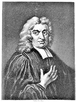
Rev. Francis Blomefield, FSA, Rector of Fersfield in Norfolk, was an English antiquarian who wrote a county history of Norfolk: An Essay Towards a Topographical History of the County of Norfolk. It includes detailed accounts of the City of Norwich, the Borough of Thetford and all parishes in the southernmost Hundreds of Norfolk, but he died before completing it. This was done by a friend, Rev. Charles Parkin. The Norfolk historian Walter Rye related that although no portrait of him was known to exist, Blomefield closely resembled the astronomer John Flamsteed, whose portrait was used to depict Blomefield on the frontispiece of one of his volumes. His history of Norfolk was reissued in London in 11 volumes by William Miller in 1805–1810, the last seven being by Parkin.

Barton Bendish is a civil parish and small ancient village in the English county of Norfolk located 10 miles (16 km) south of King's Lynn and 90 miles (140 km) North East of London. It has two medieval parish churches, and once had three. The parish includes the old hamlet of Eastmoor, and covers 3,936 acres (1,593 ha). The village has been settled since Neolithic times and was expanded during the Saxon period. Today the village has a population of 210 as recorded at the 2010 census and contains eight listed buildings, with the two medieval parishes churches being Grade I.

Beachamwell is a village and civil parish in the Breckland district of Norfolk, England about 5 miles (8.0 km) south west of Swaffham and 10 miles (16 km) east of Downham Market. It has four ancient churches, two of them in ruins. The former parish of Shingham has been annexed.

Billingford is a village and civil parish in the Breckland district of Norfolk, England, about 3+1⁄2 miles (5.6 km) north of East Dereham. The village is just north of the River Wensum, which forms the southern boundary of the parish. The village is on the B1145 road, which links King's Lynn and Mundesley. The 2011 Census recorded the parish population as 253.

Ringstead is a village and civil parish in the north-west corner of the English county of Norfolk. It covers an area of 11.13 km2 (4.30 sq mi) and had a population of 355 in 155 households at the 2001 census, reducing to 324 at the 2011 Census. For the purposes of local government, it falls within the district of King's Lynn and West Norfolk.
Winfarthing is a village and civil parish in the English county of Norfolk. It is located 6 km north of the town of Diss, 20 km east of the town of Thetford, and 30 km south of the city of Norwich. The gold and garnet Anglo Saxon Winfarthing pendant was found nearby in 2014.

Mundford is a village and civil parish in the English county of Norfolk. It is situated at the intersection of two major routes, the A134 Colchester to King's Lynn road and the A1065 Mildenhall to Fakenham road, about 8 miles (13 km) north west of Thetford. The village is 35 miles (56 km) from the city of Norwich and 88 miles (142 km) from London.

Hevingham is a village and civil parish in the Broadland district of the English county of Norfolk. Situated between the A140 road Norwich to Cromer road and the B1149 road Norwich to Holt road. It is 7 miles (11 km) north from the city of Norwich and 4 miles (6.4 km) south from the market town of Aylsham.

Sisland, historically Sislanda, is a very small village, manor and parish in the county of Norfolk, England, about a mile west of Loddon. In the 2001 census, the population was 44 in 16 households. The parish covers an area of 1.90 km2 (0.73 sq mi), and is approximately 9.3 miles (15.0 km) southeast of Norwich and 12.7 miles (20.4 km) west of Great Yarmouth. For the purposes of local government, it falls within the district of South Norfolk, however Sisland does have its own Parish Council. The village contains only one heritage-listed building, that being St Mary's Church, which is Grade II*.
Roydon is a small village, parish and electoral ward in the county of Norfolk, England, about a mile west of Diss. It covers an area of 5.54 km2 (2.14 sq mi) and had a population of 2,358 in 981 households at the 2001 census, the population of both parish and ward increasing to 2,457 at the 2011 Census.

Gissing is a village and civil parish in Norfolk, England, about 6 miles (9.7 km) north of Diss and 15 miles (24 km) south-west of Norwich.

Fordham is a small village and civil parish in the English county of Norfolk. The village is located 2.2 miles (3.5 km) north of Downham Market and 39 miles (63 km) west of Norwich, located along the A10 between London and King's Lynn and close to the confluence of the River Wissey and River Great Ouse.

Thuxton is a small village and former civil parish, now in the parish of Garvestone, Reymerston and Thuxton, in the Breckland district, in the county of Norfolk, England. It is 6 miles north west of Wymondham and 5 miles south east of Dereham. In 1931 the parish had a population of 83. The village retains a church, St Paul's, which has a monthly service and special events. On the 1st of April 1935 the parish was merged with Thuxton to form "Garveston", later the parish was renamed to "Garvestone, Reymerston and Thuxton".
Lynford is a village and civil parish in the Breckland District of Norfolk. The parish covers an area of 24.72 km2 (9.54 sq mi), and the 2001 Census recorded a population of 157 in 81 households. Lynford lies 4 miles (6.4 km) north east of Brandon and between Mundford, 2 miles (3.2 km) to the north west, and Thetford, 6.5 miles (10.5 km) to the south east, on the A134. It lies deep within Breckland forestry land between the Stanford Training Area and Thetford Forest.
Flixton is a village and civil parish located in the north of the English county of Suffolk. It is around 2 miles (3.2 km) south-west of Bungay in the East Suffolk district and is one of the villages around Bungay which make up the area known as The Saints. The A143 road runs just to the north of the parish border linking Bungay with Harleston and Diss.

Thelveton is a village and former civil parish, now in the parish of Scole, in the South Norfolk district, in the county of Norfolk, England. In 1931 the parish had a population of 161.

Fersfield is a village and former civil parish, now in the parish of Bressingham, in the South Norfolk district, in the county of Norfolk, England. The village is located 3.8 miles (6.1 km) north-west of Diss and 19 miles (31 km) south-west of Norwich. It was the home parish of Francis Blomefield, whose History of Norfolk documents the history of much of South Norfolk. In 1931 the parish had a population of 194. On 1 April 1935 the parish was abolished and merged with Bressingham.
Buckenham Tofts is a former civil parish, now in the parish of Stanford, in the Breckland district, in the county of Norfolk, England, situated about 7 miles north of Thetford, and since 1942 situated within the Stanford Training Area, a 30,000-acre military training ground closed to the public. It was situated about one mile south of the small village of Langford, with its Church of St Andrew, and about one mile west of Stanford, with its All Saints' Church and one mile north of West Tofts, with its Church of St Mary, all deserted and demolished villages. None of these settlements are shown on modern maps but are simply replaced by "Danger Area" in red capital letters. In 1931 the parish had a population of 60. On 1 April 1935 the parish was abolished and merged with Stanford.

Shimpling is a village and former civil parish 16 miles (26 km) south of Norwich, now in the parish of Burston and Shimpling, in the South Norfolk district, in the county of Norfolk, England. In 1931 the parish had a population of 134.

