West Turin, New York

Last updated

West Turin, New York
USA New York location map.svg
Red pog.svg
West Turin
Usa edcp location map.svg
Red pog.svg
West Turin
Coordinates: 43°35′0″N75°27′49″W / 43.58333°N 75.46361°W / 43.58333; -75.46361
Country United States
State New York
County Lewis
Area
[1]
  Total102.40 sq mi (265.21 km2)
  Land102.05 sq mi (264.32 km2)
  Water0.34 sq mi (0.89 km2)
Elevation
1,857 ft (566 m)
Population
 (2010)
  Total1,524
  Estimate 
(2016) [2]
1,515
  Density14.85/sq mi (5.73/km2)
Time zone UTC-5 (Eastern (EST))
  Summer (DST) UTC-4 (EDT)
ZIP code
13325
Area code 315
FIPS code 36-049-81094
GNIS feature ID979628 [3]

West Turin is a town in Lewis County, New York, United States. The population was 1,524 at the 2010 census. [4] The name is derived from its parent town, Turin. West Turin is in the south-central part of the county and is north of Rome.

Contents

History

The town was first settled circa 1796, near Constableville. West Turin was formed from part of Turin in 1830 and was subsequently reduced in size by the formation of newer towns: Montague (1850) and Osceola (1844). The town of West Turin now includes the former town of Highmarket, which was disbanded in 1973. Highmarket had been set apart from West Turin in 1852.

Geography

According to the United States Census Bureau, the town has a total area of 102.4 square miles (265 km2), of which 102.1 square miles (264 km2) are land and 0.3 square miles (0.78 km2), or 0.33%, are water. [5]

The Black River forms the eastern town line. West Turin is on the Tug Hill Plateau of northwestern New York.

New York State Route 26 and New York State Route 12D are north-south highways. New York State Route 12 is a north-south highway near the Black River.

Climate

West Turin has a warm-summer humid continental climate (Dfb). Winter is cold and very snowy, with most days not making it to freezing. Snow can fall anytime from October to May, and a consistent snowpack is expected from November to April. Due to its elevation, it is one of the coldest, snowiest, [6] and wettest places in the state. Summer is warm during the day, but it cools off quickly at night. While West Turin is very wet year round, spring is the driest time of year with 3 to 5 inches (76 to 127 mm) of rain per month, while fall is the wettest time of year with 5 to 6 inches (130 to 150 mm) per month.

The highest recorded temperature was 94 °F (34 °C) on June 28, 2005, and August 10, 2001. The coldest recorded temperature was −40 °F (−40 °C) on January 25, 26 and 27 in 2004. The highest minimum temperature was 69 °F (21 °C) on July 18, 2005, July 19, 2013, and July 22, 2011. The lowest high on record was −15 °F (−26 °C) on January 16, 2004.

The low temperature falls below freezing on an average of 188.5 days per year, and it falls below 0 °F (−18 °C) on 36.5. The average lowest temperature in a year is −29.5 °F (−34 °C), putting West Turin in hardiness zone 4A. The high stays below freezing on an average of 81.1 days per year and exceeds 90 °F (32 °C) on 0.8 days per year.

Climate data for Highmarket, New York, 1991–2020 normals, extremes 2000–present
MonthJanFebMarAprMayJunJulAugSepOctNovDecYear
Record high °F (°C)55
(13)
63
(17)
75
(24)
84
(29)
90
(32)
94
(34)
92
(33)
94
(34)
88
(31)
81
(27)
69
(21)
61
(16)
94
(34)
Mean maximum °F (°C)47.3
(8.5)
45.9
(7.7)
55.5
(13.1)
73.0
(22.8)
83.5
(28.6)
86.1
(30.1)
88.2
(31.2)
85.7
(29.8)
83.4
(28.6)
72.4
(22.4)
61.6
(16.4)
50.1
(10.1)
89.5
(31.9)
Mean daily maximum °F (°C)24.6
(−4.1)
27.6
(−2.4)
35.8
(2.1)
49.4
(9.7)
64.5
(18.1)
72.3
(22.4)
77.7
(25.4)
75.7
(24.3)
68.0
(20.0)
54.4
(12.4)
41.2
(5.1)
30.9
(−0.6)
51.8
(11.0)
Daily mean °F (°C)14.1
(−9.9)
16.3
(−8.7)
24.6
(−4.1)
38.5
(3.6)
52.0
(11.1)
60.5
(15.8)
65.4
(18.6)
63.6
(17.6)
56.4
(13.6)
44.8
(7.1)
32.7
(0.4)
22.2
(−5.4)
40.9
(5.0)
Mean daily minimum °F (°C)3.6
(−15.8)
4.9
(−15.1)
13.4
(−10.3)
27.6
(−2.4)
39.5
(4.2)
48.6
(9.2)
53.0
(11.7)
51.5
(10.8)
44.7
(7.1)
35.2
(1.8)
24.2
(−4.3)
13.4
(−10.3)
30.0
(−1.1)
Mean minimum °F (°C)−25.9
(−32.2)
−20.3
(−29.1)
−14.5
(−25.8)
10.9
(−11.7)
24.7
(−4.1)
34.6
(1.4)
41.7
(5.4)
39.3
(4.1)
29.9
(−1.2)
19.6
(−6.9)
3.5
(−15.8)
−13.7
(−25.4)
−29.5
(−34.2)
Record low °F (°C)−40
(−40)
−36
(−38)
−29
(−34)
−5
(−21)
18
(−8)
28
(−2)
35
(2)
34
(1)
20
(−7)
11
(−12)
−26
(−32)
−36
(−38)
−40
(−40)
Average precipitation inches (mm)5.01
(127)
3.61
(92)
3.61
(92)
4.21
(107)
4.67
(119)
4.89
(124)
4.52
(115)
4.54
(115)
5.16
(131)
6.04
(153)
5.14
(131)
5.42
(138)
56.82
(1,444)
Average snowfall inches (cm)54.8
(139)
43.8
(111)
25.1
(64)
6.1
(15)
0.3
(0.76)
0.0
(0.0)
0.0
(0.0)
0.0
(0.0)
0.0
(0.0)
2.6
(6.6)
19.3
(49)
51.1
(130)
203.1
(515.36)
Average extreme snow depth inches (cm)26.2
(67)
29.2
(74)
26.9
(68)
11.1
(28)
0.1
(0.25)
0.0
(0.0)
0.0
(0.0)
0.0
(0.0)
0.0
(0.0)
1.6
(4.1)
9.5
(24)
21.5
(55)
34.9
(89)
Average precipitation days (≥ 0.01 in)20.016.415.314.014.513.713.412.313.016.215.519.4183.7
Average snowy days (≥ 0.1 in)19.016.112.15.00.50.00.00.00.01.68.417.079.7
Source 1: NOAA [7]
Source 2: National Weather Service (mean maxima/minima 20062020) [8]

Demographics

Historical population
CensusPop.Note
1830 1,534
1840 2,04233.1%
1850 3,79385.7%
1860 2,410−36.5%
1870 2,111−12.4%
1880 2,006−5.0%
1890 1,803−10.1%
1900 1,779−1.3%
1910 1,9419.1%
1920 1,929−0.6%
1930 1,886−2.2%
1940 1,806−4.2%
1950 1,781−1.4%
1960 1,9057.0%
1970 1,713−10.1%
1980 1,8679.0%
1990 1,753−6.1%
2000 1,675−4.4%
2010 1,524−9.0%
2016 (est.)1,515 [2] −0.6%
U.S. Decennial Census [9]

As of the census [10] of 2000, there were 1,674 people, 635 households, and 433 families residing in the town. The population density was 16.4 people per square mile (6.3/km2). There were 971 housing units at an average density of 9.5 per square mile (3.7/km2). The racial makeup of the town was 99.22% White, 0.18% Native American, 0.06% Asian, 0.24% from other races, and 0.30% from two or more races. Hispanic or Latino of any race were 0.12% of the population.

There were 635 households, out of which 31.2% had children under the age of 18 living with them, 51.8% were married couples living together, 10.1% had a female householder with no husband present, and 31.7% were non-families. 25.8% of all households were made up of individuals, and 13.2% had someone living alone who was 65 years of age or older. The average household size was 2.64 and the average family size was 3.16.

In the town, the population was spread out, with 27.4% under the age of 18, 7.9% from 18 to 24, 27.7% from 25 to 44, 22.2% from 45 to 64, and 14.9% who were 65 years of age or older. The median age was 38 years. For every 100 females, there were 104.9 males. For every 100 females age 18 and over, there were 101.7 males.

The median income for a household in the town was $35,150, and the median income for a family was $41,618. Males had a median income of $32,065 versus $21,838 for females. The per capita income for the town was $15,538. About 13.5% of families and 16.4% of the population were below the poverty line, including 19.8% of those under age 18 and 13.8% of those age 65 or over.

Communities and locations in West Turin

Related Research Articles

<span class="mw-page-title-main">Caroga, New York</span> Town in New York, United States

Caroga is a town in Fulton County, New York, United States. The population was 1,205 at the 2010 census. The town was named after a local creek.

<span class="mw-page-title-main">Ephratah, New York</span> Town in New York, United States

Ephratah is a town in Fulton County, New York, United States. The population was 1,682 at the 2010 census. It is named after Ephrath, a biblical town in what is now Israel.

<span class="mw-page-title-main">Danube, New York</span> Town in New York, United States

Danube is a town in Herkimer County, New York, United States. The population was 801 at the 2020 census, down from 1,039 in 2010. Early Palatine German immigrants in the eighteenth century named the town after the Danube River in Europe.

<span class="mw-page-title-main">German Flatts, New York</span> Town in Herkimer County, New York, US

German Flatts is a town in Herkimer County, New York, United States. The population was 12,263 at the 2020 census down from 13,258 at the 2010 census.

<span class="mw-page-title-main">Manheim, New York</span> Town in New York, United States

Manheim is a town in Herkimer County, New York, United States. The population was 3,334 at the 2010 census. The town name is derived from Mannheim in Baden, Germany.

Constableville is a village in Lewis County, New York, United States. The population was 242 at the 2010 census. The village is named after William Constable, the son of an early landowner.

Lewis is a town in Lewis County, New York, United States. The population was 854 at the 2010 census. The town is named after its county, which is named after former governor, Morgan Lewis.

Leyden is a town in Lewis County, New York, United States. The population was 1,785 at the 2010 census. The town is in the southern part of the county and is north of Rome.

Lyons Falls is a village in Lewis County, New York, United States. The population was 566 at the 2010 census. The village is on the border of the towns of West Turin and Lyonsdale. It is at the junction of state Routes 12 and 12D, approximately 14 miles (23 km) south of Lowville, the county seat.

<span class="mw-page-title-main">Martinsburg, New York</span> Town in New York, United States

Martinsburg is a town in Lewis County, New York, United States. The population was 1,433 at the 2010 census. The town is named after its founding father, General Walter Martin.

Montague is a town in Lewis County, New York, United States. The population was 78 at the 2010 census. The town is named after Mary Montague Pierpont, the daughter of the original owner.

<span class="mw-page-title-main">Glen, New York</span> Town in New York, United States

Glen is a town in Montgomery County, New York, United States. The population was 2,507 at the 2010 census. The town was named after Jacob Glen, an early landowner.

<span class="mw-page-title-main">Mohawk, Montgomery County, New York</span> Town in New York, United States

Mohawk is a town in Montgomery County, New York, United States. The population was 3,844 at the 2010 census.

<span class="mw-page-title-main">Root, New York</span> Town in New York, United States

Root is a town in Montgomery County, New York, United States. The population was 1,715 at the 2010 census. The town was named for Erastus Root, a legislator in the early Federal period.

<span class="mw-page-title-main">Halfmoon, New York</span> Town in New York, United States

Halfmoon is a town in Saratoga County, New York, United States. The population was 25,662 at the 2020 census. The town is apparently named for the shape of the lower elevation land north of the junction of the Hudson and Mohawk Rivers. It is also said to be named for Henry Hudson's ship, the Halve Maen.

<span class="mw-page-title-main">Fremont, Sullivan County, New York</span> Town in New York, United States

Fremont is a town in Sullivan County, New York, United States. The population was 1,161 at the 2020 census.

<span class="mw-page-title-main">Herkimer, New York</span> Town in New York, United States

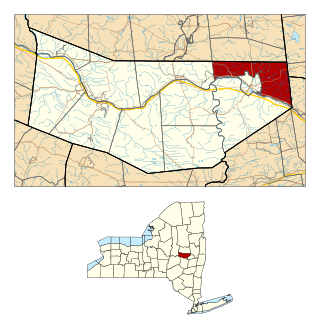
Herkimer is a town in Herkimer County, New York, United States, southeast of Utica. It is named after Nicholas Herkimer. The population was 9,566 at the 2020 census, down from 10,175 in 2010.

<span class="mw-page-title-main">Little Falls (town), New York</span> Town in New York, United States

Little Falls is a town in Herkimer County, New York, United States. The population was 1,587 at the 2010 census. The town is named after falls and rapids on the Mohawk River nearby.

<span class="mw-page-title-main">Amsterdam (town), New York</span> Town in New York, United States

Amsterdam is a town in Montgomery County, New York, United States. The population was 5,566 at the 2010 census. The town is named after Amsterdam, the capital of the Netherlands.

<span class="mw-page-title-main">Boonville, New York</span> Town in New York, United States

Boonville is a town in Oneida County, New York, United States. The town is in the northeastern section of the county. The population was 4,555 at the 2010 census. The town includes a village, also called Boonville. The town and village are named after Gerrit Boon, an agent of the Holland Land Company. The current mayor is Judith Dellerba.

References

  1. "2016 U.S. Gazetteer Files". United States Census Bureau. Retrieved July 5, 2017.
  2. 1 2 "Population and Housing Unit Estimates" . Retrieved June 9, 2017.
  3. U.S. Geological Survey Geographic Names Information System: West Turin, New York
  4. "Total Population: 2010 Census DEC Summary File 1 (P1), West Turin town, New York". data.census.gov. U.S. Census Bureau. Retrieved May 28, 2020.
  5. "U.S. Gazetteer Files: 2019: Places: New York". U.S. Census Bureau Geography Division. Retrieved May 28, 2020.
  6. Wiltgen, Nick (October 27, 2016). "The snowiest place in each state". The Weather Channel. The Weather Channel. Retrieved May 8, 2019.
  7. "U.S. Climate Normals Quick Access – Station: Highmarket 2W, NY". National Oceanic and Atmospheric Administration. Retrieved January 26, 2023.
  8. "NOAA Online Weather Data – NWS Buffalo". National Weather Service. Retrieved January 26, 2023.
  9. "Census of Population and Housing". Census.gov. Retrieved June 4, 2015.
  10. "U.S. Census website". United States Census Bureau . Retrieved January 31, 2008.
  11. "National Register of Historic Places Listings". Weekly List of Actions Taken on Properties: 5/05/14 through 5/09/14. National Park Service. May 16, 2014.