
Doddridge County is a county in the U.S. state of West Virginia. As of the 2020 census, the population was 7,808. Its county seat is West Union.

West Union, incorporated July 20, 1881, is a town in Doddridge County, West Virginia, United States. The population was 669 at the 2020 census. It is the county seat of Doddridge County. The town is located along Middle Island Creek at the junction of U.S. Route 50 and West Virginia Route 18; the North Bend Rail Trail also passes through the town.

Grafton is a city in and the county seat of Taylor County, West Virginia. The population was 4,729 at the 2020 census. It originally developed as a junction point for the Baltimore and Ohio Railroad, serving numerous branches of a network that was vital to the regional coal industry.

Claude "Claudius" Crozet was a soldier, educator, and civil engineer.
The Northwestern Turnpike is a historic road in West Virginia, important for being historically one of the major roads crossing the Appalachians, financed by the Virginia Board of Public Works in the 1830s. In modern times, west of Winchester, Virginia, U.S. Route 50 follows the path of the Northwestern Turnpike into West Virginia, whose major Corridor D project follows the western section of the original Northwestern Turnpike.

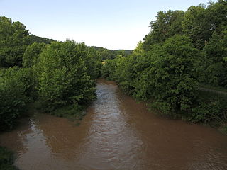
Middle Island Creek is a river, 77 miles (124 km) long, in northwestern West Virginia in the United States. It is a tributary of the Ohio River, draining an area of 565 square miles (1,463 km2) on the unglaciated Allegheny Plateau. It was named by late 18th century pioneering travelers on the Ohio River, who noted the location of the Creek's mouth opposite Middle Island in the larger river.
Ephraim Bee was an American pioneer, blacksmith, and inn-keeper of Doddridge County, West Virginia, which he represented in the West Virginia House of Delegates in 1863 and 1866–1867.

Waitman Thomas Willey was an American lawyer and politician from Morgantown, West Virginia. One of the founders of the state of West Virginia during the American Civil War, he served in the United States Senate representing first the Restored Government of Virginia and became one of the new state of West Virginia's first two senators. He is one of only two people in U.S. History to represent more than one state in the U.S. Senate, the other being James Shields.

Bunker Hill is an unincorporated community in Berkeley County, West Virginia, United States, located in the lower Shenandoah Valley on Winchester Pike at its junction with County Route 26 south of Martinsburg. It is the site of the confluence of Torytown Run and Mill Creek, a tributary of Opequon Creek which flows into Winchester, Virginia. According to the 2000 census, the Bunker Hill community has a population of 5,319.
The Jug — formerly known as the Jug Handle — is a jug-shaped island formed by a horseshoe bend on Middle Island Creek near Middlebourne in Tyler County, West Virginia, USA. It is maintained by the state of West Virginia as The Jug Wildlife Management Area.

The Humpback Covered Bridge located in the U.S. state of Virginia, is one of the few remaining covered bridges in the United States that was built higher in the middle than on either end; hence the name of "humpback". The bridge was built in 1857 and is also the oldest remaining covered bridge in the state of Virginia. Its WGCB number is 46-03-01. The bridge spans a tributary of the Jackson River known as Dunlap Creek, for a distance of 109 feet (33 m). The humpback feature is 4 feet (1.2 m) higher in the center than at either end. The bridge is located near the city of Covington, Virginia.

Lemuel Chenoweth was a carpenter, legislator and self-taught architect. He is best known as one of 19th century America's master covered bridge builders.
The Staunton-Parkersburg Turnpike was built in what is now the U.S. states of Virginia and West Virginia during the second quarter of the 19th century to provide a roadway from Staunton, Virginia and the upper Shenandoah Valley to the Ohio River at present-day Parkersburg, West Virginia. Engineered by Claudius Crozet through the mountainous terrain, it was a toll road partially funded by the Virginia Board of Public Works. Control of this road became crucial during the American Civil War. Today, the Staunton-Parkersburg Turnpike can be largely traversed by following West Virginia Route 47 east from Parkersburg to Linn, then U.S. Route 33 east through Weston and Buckhannon to Elkins, then U.S. Route 250 southeast through Beverly, Huttonsville, crossing the West Virginia/Virginia state line to Staunton, Virginia.

The Clarkson–Legg Covered Bridge, more simply known as Clarkson Covered Bridge, is a county-owned wooden covered bridge that spans Crooked Creek in Cullman County, Alabama, United States. It is located at Clarkson Covered Bridge Park on County Road 1043 off U.S. Route 278 near the community of Bethel, about 8 mi (13 km) west of Cullman.
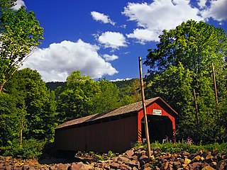
Center Point is an unincorporated community in northeastern Doddridge County, West Virginia, United States. It lies along Route 23 northeast of the town of West Union, the county seat of Doddridge County. Its elevation is 791 feet (241 m).
The Sonestown Covered Bridge is a covered bridge over Muncy Creek in Davidson Township, Sullivan County, Pennsylvania built around 1850. It is 110 ft (34 m) long and was placed on the National Register of Historic Places (NRHP) in 1980. It is named for the nearby unincorporated village of Sonestown in Davidson Township, and is also known as the Davidson Covered Bridge. It was built to provide access to a grist mill which operated until the early 20th century.
Plunketts Creek Bridge No. 3 was a rubble masonry stone arch bridge over Plunketts Creek in Plunketts Creek Township, Lycoming County in the U.S. state of Pennsylvania. It was built between 1840 and 1875, probably closer to 1840, when the road along the creek between the unincorporated villages of Barbours and Proctor was constructed. Going upstream from the mouth, the bridge was the third to cross the creek, hence its name.

The Center Point Covered Bridge is a historic covered bridge near Center Point, Doddridge County, West Virginia, United States.
McElroy Creek is a tributary of Middle Island Creek, 22.1 miles (35.6 km) long, in northern West Virginia in the United States. Via Middle Island Creek and the Ohio River, it is part of the watershed of the Mississippi River, draining an area of 106.2 square miles (275 km2) in a rural region on the unglaciated portion of the Allegheny Plateau.


