West Valley, Washington

Last updated

West Valley, Washington
CDP
Yakima County Washington Incorporated and Unincorporated areas West Valley Highlighted.svg
Location of West Valley, Washington
Coordinates: 46°35′55″N120°36′11″W / 46.59861°N 120.60306°W / 46.59861; -120.60306
CountryUnited States
State Washington
County Yakima
Area
  Total7.2 sq mi (18.7 km2)
  Land7.2 sq mi (18.7 km2)
  Water0.0 sq mi (0.0 km2)
Elevation
1,194 ft (364 m)
Population
 (2000)
  Total10,433
  Density1,448.3/sq mi (559.5/km2)
Time zone UTC-8 (Pacific (PST))
  Summer (DST) UTC-7 (PDT)
FIPS code 53-77885 [1]
GNIS feature ID1867646 [2]

West Valley is a former census-designated place (CDP) in Yakima County, Washington, United States. The area has been annexed by the city of Yakima. [3] The population was 10,433 at the 2000 census.

Contents

Based on per capita income, West Valley ranks 76th of 522 areas in the state of Washington to be ranked.

It has a school district, West Valley School District, which has a high school outside of town.

Geography

West Valley is located at 46°35′55″N120°36′11″W / 46.59861°N 120.60306°W / 46.59861; -120.60306 (46.598731, -120.603011). [4]

According to the United States Census Bureau, the CDP has a total area of 7.2 square miles (18.6 km2), all of it land.

Demographics

As of the census [1] of 2000, there were 10,433 people, 3,862 households, and 3,020 families residing in the CDP. The population density was 1,448.3 people per square mile (559.5/km2). There were 3,964 housing units at an average density of 550.3/sq mi (212.6/km2). The racial makeup of the CDP was 89.60% White, 0.82% African American, 0.90% Native American, 2.04% Asian, 0.13% Pacific Islander, 3.88% from other races, and 2.62% from two or more races. Hispanic or Latino of any race were 8.72% of the population.

There were 3,862 households, out of which 39.9% had children under the age of 18 living with them, 64.8% were married couples living together, 10.2% had a female householder with no husband present, and 21.8% were non-families. 17.0% of all households were made up of individuals, and 6.1% had someone living alone who was 65 years of age or older. The average household size was 2.70 and the average family size was 3.04.

In the CDP, the age distribution of the population shows 29.2% under the age of 18, 6.8% from 18 to 24, 27.9% from 25 to 44, 25.4% from 45 to 64, and 10.7% who were 65 years of age or older. The median age was 36 years. For every 100 females, there were 93.6 males. For every 100 females age 18 and over, there were 89.5 males.

The median income for a household in the CDP was $51,201, and the median income for a family was $55,636. Males had a median income of $41,103 versus $28,922 for females. The per capita income for the CDP was $25,765. About 4.0% of families and 5.1% of the population were below the poverty line, including 4.4% of those under age 18 and 3.7% of those age 65 or over.

Related Research Articles

Bret Harte is a census-designated place (CDP) in Stanislaus County, California, United States. The population was 5,152 at the 2010 census, down from 5,161 at the 2000 census. It is part of the Modesto Metropolitan Statistical Area. It is named for the American poet and short story writer, Bret Harte, best known for his writings about the California Gold Rush.

<span class="mw-page-title-main">Fairview Shores, Florida</span> Census-designated place in Florida, United States

Fairview Shores is a census-designated place and an unincorporated area in Orange County, Florida, United States. The population was 10,239 at the 2010 census. It is part of the Orlando–Kissimmee–Sanford, Florida Metropolitan Statistical Area.

<span class="mw-page-title-main">Helena Valley Southeast, Montana</span> Census-designated place in Montana, United States

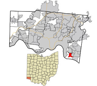
Helena Valley Southeast is a census-designated place (CDP) in Lewis and Clark County, Montana, United States. The population was 8,227 at the 2010 census. It is part of the Helena Micropolitan Statistical Area.

<span class="mw-page-title-main">Helena West Side, Montana</span> Census-designated place in Montana, United States

Helena West Side is a census-designated place (CDP) in Lewis and Clark County, Montana, United States. The population was 1,637 at the 2010 census, down from 1,711 at the 2000 census due to annexation of part of the CDP by the city of Helena. It is part of the Helena Micropolitan Statistical Area.

<span class="mw-page-title-main">Holiday Valley, Ohio</span> Census-designated place in Ohio, United States

Holiday Valley is a census-designated place (CDP) in Mad River Township, Clark County, Ohio, United States. The population was 1,480 at the 2020 census. It is part of the Springfield, Ohio Metropolitan Statistical Area. Holiday Valley became a CDP in the 1990 United States Census.

<span class="mw-page-title-main">West Brattleboro, Vermont</span> CDP in Vermont, United States

West Brattleboro is a census-designated place (CDP) in the town of Brattleboro, Vermont, United States. The population was 3,222 at the 2000 census.

<span class="mw-page-title-main">Central Park, Washington</span> CDP in Washington, United States

Central Park is a census-designated place (CDP) in Grays Harbor County, Washington, United States. The population was 2,841 at the 2020 census.

<span class="mw-page-title-main">Easton, Washington</span> Census-designated place in Washington, United States

Easton is an unincorporated community and census-designated place (CDP) in Kittitas County, Washington, United States. The population was 478 at the 2010 census. Easton is the annual site of the start/finish line for the Cascade Crest 100-mile ultra-running race.

<span class="mw-page-title-main">Ahtanum, Washington</span> CDP in Washington, United States

Ahtanum is a census-designated place (CDP) in Yakima County, Washington. The population was 4,046 at the time of the 2020 census.

<span class="mw-page-title-main">Eschbach, Washington</span> CDP in Washington, United States

Eschbach is a census-designated place (CDP) in Yakima County, Washington, United States. The population was 441 at the 2020 census.

<span class="mw-page-title-main">Gleed, Washington</span> CDP in Washington, United States

Gleed is a census-designated place (CDP) in Yakima County, Washington, United States. The population was 2,873 at the 2020 census.

<span class="mw-page-title-main">Harrah, Washington</span> Town in Washington, United States

Harrah is a town in Yakima County, Washington, United States. The population was 585 at the 2020 census. It is on the Yakama Indian Reservation. The mayor is Barbara Harrer.

<span class="mw-page-title-main">Naches, Washington</span> Town in Washington, United States

Naches is a town in Yakima County, Washington, United States. The population was 1,084 at the 2020 census.

<span class="mw-page-title-main">Satus, Washington</span> CDP in Washington, United States

Satus is a census-designated place (CDP) in Yakima County, Washington, United States, located on the eastern corner of the Yakama Indian Reservation. The population was 746 at the 2000 census. It is southwest from the Toppenish National Wildlife Refuge. The community was not recognized in the 2010 census. The area was first settled and established as a post office location in 1890.

<span class="mw-page-title-main">Selah, Washington</span> City in Washington, United States

Selah is a city in Yakima County, Washington, United States. It is north of Yakima and part of its metropolitan area. The city's population was 8,153 at the 2020 census.

<span class="mw-page-title-main">Summitview, Washington</span> CDP in Washington, United States

Summitview is a census-designated place (CDP) in Yakima County, Washington, United States. The population was 2,066 at the 2020 census, a dramatic increase of 967 from the 2010 census.

<span class="mw-page-title-main">Terrace Heights, Washington</span> CDP in Washington, United States

Terrace Heights is a census-designated place (CDP) in Yakima County, Washington, United States. The population was 9,244 at the 2020 census. It is essentially a suburb of the city of Yakima.

<span class="mw-page-title-main">Union Gap, Washington</span> City in Washington, United States

Union Gap is a city in Yakima County, Washington, United States. As of the 2020 census, the city population was 6,568. Union Gap has become the retail hub for the entire Yakima Valley as a result of Valley Mall and other thriving businesses being located here. Part of the city is part of the Yakama Nation.

<span class="mw-page-title-main">White Swan, Washington</span> CDP in Washington, United States

White Swan is a census-designated place (CDP) in Yakima County, Washington, United States. The population was 789 at the 2020 census.

<span class="mw-page-title-main">Salem Heights, Hamilton County, Ohio</span> Census-designated place in Ohio, United States

Salem Heights is a census-designated place (CDP) in Anderson Township, Hamilton County, Ohio, United States, adjacent to the city of Cincinnati. The population of Salem Heights was 3,862 at the 2020 census.

References

  1. 1 2 "U.S. Census website". United States Census Bureau . Retrieved January 31, 2008.
  2. "US Board on Geographic Names". United States Geological Survey. October 25, 2007. Retrieved January 31, 2008.
  3. U.S. Census Bureau Geographic Change Notes
  4. "US Gazetteer files: 2010, 2000, and 1990". United States Census Bureau. February 12, 2011. Retrieved April 23, 2011.