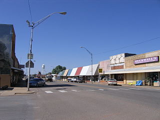
In the 21st century, it is the headquarters for two federally recognized tribes, the Alabama-Quassarte Tribal Town and the Kialegee Tribal Town. The town holds Sucker Day annually, on the last Saturday in September.[5]
History
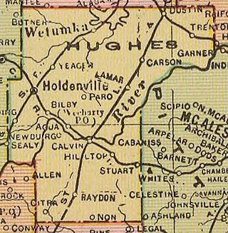
The St. Louis, Oklahoma and Southern Railway[lower-alpha 1] built a line from Sapulpa, Oklahoma through Wetumka to the Red River in 1900-1901. Wetumka prospered as a major shipping point for cotton, corn, pecans, and livestock produced by farmers in the surrounding area. An election was held in 1908 to determine the permanent county seat, and Wetumka made it to a runoff election for that title, although Holdenville prevailed.[6] By 1909, the community had three banks, two cotton gins, three blacksmith shops, two liveries, and a tin shop. Early newspapers included the Wetumka News-Herald, the Wetumka News, the Wetumka Herald, and the Wetumka Gazette. A two-story building constructed in 1912 housed the city hall and the Masonic Lodge.[5]
By 1918, four cotton gins, a mill and elevator, a wagonyard, an ice company, and a water and light company had joined the list of businesses open in Wetumka. The 1920 census reported that the population had jumped from 231 in 1910 to 1422 in 1920.[5] Growth would continue through 1950. Since then a long-term decline has lasted through the 2010 census as agriculture has needed fewer workers.
The Wetumka oil field opened in 1919. A crowd of oil workers poured into town. The Encyclopedia of Oklahoma History and Culture estimates the number of temporary workers brought the total city population to about four thousand.[5] However, the 1920 census does not support this number. There was sufficient activity to cause the railroad to build a large freight warehouse in April 1925. A three-story hotel opened in June of that year. With the booming economy, the city paved the streets and added three rooms to the school building.
Perhaps the most significant sign of growth was that the citizens petitioned Governor Jack C. Walton to designate Wetumka as a city of the "first class". Walton signed the proclamation on May 21, 1923, and the city held an election on June 26, 1925 for a mayor, a city marshal, and council members.[5]
By 1930, oil and agriculture were the dominant employers in Wetumka's economy, with five cotton gins and twelve oil companies operating. The city had added nine churches, a park, a lake, and a junior college. Railey Manufacturing Company provided employment to workers who crafted wood flooring and doors. Municipal plants provided water and electricity, Oklahoma Natural Gas supplied gas, and Southwestern State Telephone furnished phone service. But in the 1930s, cotton production began a major decline.
During World War II, the Army operated a prisoner-of-war camp for German prisoners. This closed in 1945 after the end of the war. The city-owned Wetumka General Hospital opened in March 1960. In March 1973 a municipal complex opened to replace city hall, which had been destroyed by fire on November 13, 1971. By the 1970s all cotton gins were defunct.[5]
Geography
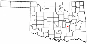
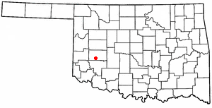
Wetumka is approximately 15 miles (24km) northeast of Holdenville, the county seat.[5]
According to the United States Census Bureau, the city has a total area of 1.9 square miles (4.9km2), of which 1.9 square miles (4.9km2) is land and 20% is water.
As of the census[3] of 2000, there were 1,451 people, 591 households, and 346 families residing in the city. The population density was 760.8 inhabitants per square mile (293.7/km2). There were 700 housing units at an average density of 367.0 per square mile (141.7/km2). The racial makeup of the city was 58.37% White, 5.65% African American, 31.63% Native American, 0.07% Pacific Islander, 0.21% from other races, and 4.07% from two or more races. Hispanic or Latino of any race were 2.55% of the population.
There were 591 households, out of which 26.1% had children under the age of 18 living with them, 37.4% were married couples living together, 16.4% had a female householder with no husband present, and 41.3% were non-families. 38.6% of all households were made up of individuals, and 22.7% had someone living alone who was 65 years of age or older. The average household size was 2.31 and the average family size was 3.06.
In the city, the population was spread out, with 26.9% under the age of 18, 8.1% from 18 to 24, 23.7% from 25 to 44, 22.5% from 45 to 64, and 18.8% who were 65 years of age or older. The median age was 39 years. For every 100 females, there were 86.7 males. For every 100 females age 18 and over, there were 78.3 males.
The median income for a household in the city was $17,000.00, and the median income for a family was $21,645. Males had a median income of $18,194 versus $14,091 for females. The per capita income for the city was $9,455. About 31.3% of families and 39.6% of the population were below the poverty line, including 48.4% of those under age 18 and 29.8% of those age 65 or over.
Education
The first school in Wetumka was the Levering Manual Labor Mission School, which opened on September 1, 1881. It was operated by the Home Mission Board of the Southern Baptist Convention, partly funded by the Creek Nation and educated Creek children. The town had a public school system by 1902 The Wes Watkins Technology Center is located in Wetumka. Opened in 1992, it offers vocational training.[5]
Activities
Wetumka was conned by a man named F. Bam Morrison in 1950, and the town laughs about it each year through a celebration called Sucker Day.[7][8] The event has arts and crafts, music, and a parade of antique cars, tractors, and horses.[8] There is also a ”poker run” for motorcyclists and other participants.[8]
Wetumka Lake, a/k/a Lake Wetumka, offering boat ramps/docks, a fishing dock, picnic areas, a playground, and primitive camping sites, is to the north.[9][10]
Wetumka is home to Petes Airpark (FAA Identifier: 8OL1), a privately-owned facility.[12] At least six other airports, including Okmulgee Regional and McAlester Regional, are within a 35-mile radius.[12]
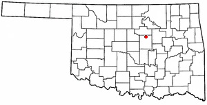
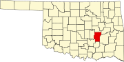
Hughes County is a county located in south central U.S. state of Oklahoma. As of the 2020 census, the population was 13,367. Its county seat is Holdenville. The county was named for W. C. Hughes, an Oklahoma City lawyer who was a member of the Oklahoma Constitutional Convention.
Seiling is a city in Dewey County, Oklahoma, United States. The population was 850 at the 2020 census. The town was named in 1899 for Louis Seiling, a local store owner who had acquired a homestead in the Cheyenne-Arapaho land run of April 1892. The Hobson Town and Improvement Company established a town called Hobson, but the name was changed to Seiling in January 1899. It incorporated in 1909. Seiling is now the largest city in Dewey County. Their girls basketball team has also won the Oklahoma State Championship four times in a row (2016-2019).
Calvin is a town in Hughes County, Oklahoma, United States. The population was 294 at the 2010 census.
Dustin is a town in Hughes County, Oklahoma, United States. The population was 327 at the time of the 2020 United States census.
Holdenville is a city in and county seat of Hughes County, Oklahoma, United States. The population was 5,934 at the time of the 2020 United States census, a 2.8% increase over the 5,771 reported at the 2010 census, which in turn was an increase of 22 percent over the 4,732 reported at the 2000 census.
Horntown is a town in Hughes County, Oklahoma, United States. The population was 97 at the 2010 census, up from the figure of 61 recorded in 2000.
Lamar is a town in Hughes County, Oklahoma, United States. The population was 158 at the 2010 census.
Stuart is a town in southeastern Hughes County, Oklahoma, United States. The population was 180 at the 2010 census, down from 220 in 2000.
Yeager is a town in Hughes County, Oklahoma, United States. The population was 75 at the 2010 census. Developed in the early 1900s, the town grew with the help of an oil and gas field, but has always had a low population.
Spiro is a town in Le Flore County, Oklahoma, United States. It is part of the Fort Smith, Arkansas-Oklahoma Metropolitan Statistical Area. The population was 2,164 at the 2010 census, a 2.8 percent decline from the figure of 2,227 recorded in 2000.
Agra is a town in northern Lincoln County, Oklahoma, United States. The population was 339 at the 2010 census. An early real estate developer coined the town's name from the word "agriculture".
Haskell is a city, as of March 2024, in Muskogee County, Oklahoma, United States. The population was 2,007 at the 2010 census, a gain of 13.7 percent over the figure of 1,765 recorded in 2000. Haskell was established in 1904 on the Midland Valley Railroad. It was named for town site developer Charles N. Haskell, who would become the first governor of the State of Oklahoma in 1907.
Weleetka is a town in Okfuskee County, Oklahoma, United States. It is approximately 10 miles (16 km) southeast of Okemah, the county seat. The name is a Creek word meaning "running water." The population was 806 at the time of the 2020 census.
Henryetta is a city in Okmulgee County, Oklahoma, United States. The population was 5,640 at the 2020 census.
Skedee is a town in Pawnee County, Oklahoma, United States. Skedee is northwest of Tulsa, northeast of Stillwater, and southeast of Ponca City. The population was 62 at the time of the 2020 Census, a 21.6% increase from the figure of 51 recorded in the 2010 Census.
St. Louis is a town in Pottawatomie County, Oklahoma, United States. The population was 121 by the 2020 United States census.
Rocky is a town in Washita County, Oklahoma, United States. The population was 162 at the 2010 United States Census, a 6.9 percent decline from the figure of 174 in 2000. The town lies along U.S. Route 183.
Dodson is a town in Collingsworth County, Texas, United States. The population was 109 at the 2010 census.
Stroud is a city in Creek and Lincoln counties in the U.S. state of Oklahoma. As of the 2010 census, the city population was 2,690.
Allen is a town in Hughes and Pontotoc counties in the U.S. state of Oklahoma. The population was 805 at the 2020 census.
This page is based on this Wikipedia article Text is available under the CC BY-SA 4.0 license; additional terms may apply. Images, videos and audio are available under their respective licenses.