The Isle of Portland is a tied island, 6 kilometres (4 mi) long by 2.7 kilometres (1.7 mi) wide, in the English Channel. The southern tip, Portland Bill lies 8 kilometres (5 mi) south of the resort of Weymouth, forming the southernmost point of the county of Dorset, England. A barrier beach called Chesil Beach joins Portland with mainland England. The A354 road passes down the Portland end of the beach and then over the Fleet Lagoon by bridge to the mainland. The population of Portland is 13,417.

Chesil Beach in Dorset, England is one of three major shingle beach structures in Britain. Its name is derived from the Old English ceosel or cisel, meaning "gravel" or "shingle". It runs for a length of 29 kilometres (18 mi) from West Bay to the Isle of Portland and in places is up to 15 metres (50 ft) high and 200 metres (660 ft) wide. Behind the beach is the Fleet, a shallow tidal lagoon. Both are part of the Jurassic Coast and a UNESCO World Heritage Site, and together form an SSSI and Ramsar Site.

Weymouth and Portland was a local government district and borough in Dorset, England. It consisted of the resort of Weymouth and the Isle of Portland, and includes the areas of Wyke Regis, Preston, Melcombe Regis, Upwey, Broadwey, Southill, Nottington, Westham, Radipole, Chiswell, Castletown, Fortuneswell, Weston, Southwell and Easton; the latter six being on the Isle of Portland.

The Weymouth and Portland National Sailing Academy is a centre for the sport of sailing on the Isle of Portland, Dorset, on the south coast of England. The academy building is located in Osprey Quay on the northern tip of the island, and the waters of Portland Harbour and Weymouth Bay, adjacent to the site, are the main areas used for sailing. Local, national and international sailing events have been held at the site since it was opened in 2000, and in 2005 WPNSA was selected to host the sailing events at the 2012 Olympic and Paralympic Games.
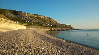
Chesil Cove is a curved steep bank forming the south-east end of 29-kilometre (18 mi) Chesil Beach in Dorset, England. It is thus part of one of three large shingle structures in Britain, extending from West Bay to the Isle of Portland, the latter acting more firmly as a great barrier (groyne) which stops tidal action from washing the beach away and leads to the high depositions by wind and tide action forming the grand curved bank of this "cove". The "cove", bill and much of Chesil Beach give shelter from the prevailing winds and waves for much of Weymouth Bay, the town of Weymouth and the village of Chiswell. It forms part of the Jurassic Coast.

Weymouth Beach is a gently curving arc of sand in Weymouth Bay, beside the town of Weymouth in Dorset, England. Immediately adjacent to the beach is The Esplanade.

Church Ope Cove is a small secluded beach on the sheltered eastern side of the Isle of Portland in Dorset, southern England and is part of the Jurassic Coast. It is found close to the village of Wakeham. The beach has many unusual features for the Isle of Portland. The beach used to be sandy, but quarry debris now covers the sand, and has been worn into rounded pebbles. The pebbles cover a small stream which runs to the sea, which is one of the few active streams remaining on the Isle of Portland.

Newton's Cove is a small cove, 0.5 kilometres (0.3 mi) south of Weymouth, Dorset, England. Overlooking Portland Harbour, the cove is close to Nothe Gardens and the Nothe Fort.

Bowleaze Cove is a small sand and shingle beach, near the village of Preston, just to the northeast of Weymouth, Dorset, England. The cove is on the Jurassic Coast and is known for its geology. Just to the west is Furzy Cliff.

Osmington Mills is a coastal hamlet in the English county of Dorset. It lies within the civil parish of Osmington 5 miles (8.0 km) northeast of Weymouth.
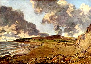
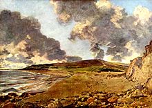
Weymouth Bay: Bowleaze Cove and Jordon Hill was painted by the leading English landscape artist John Constable between 1816 and 1817. It is the second of three oil versions of this view painted by Constable and now hangs in the National Gallery, London.
Weymouth is a seaside town in Dorset, on the English Channel coast of England. Situated on a sheltered bay at the mouth of the River Wey, 11 kilometres (7 mi) south of the county town of Dorchester, Weymouth had a population of 53,068 as of 2018. It is the third largest settlement in Dorset after Bournemouth and Poole.
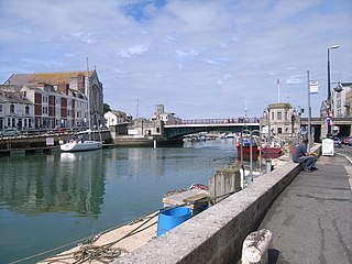
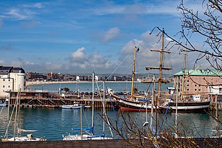
Weymouth Harbour is a picturesque harbour at the seaside town of Weymouth in Dorset, southern England,. It has a 17th-century waterfront.
There are eight settlements on the Isle of Portland, Dorset, England, the largest of which are Fortuneswell in Underhill and Easton on Tophill. The other villages of Weston, Southwell, Wakeham and the Grove also occupy Tophill, and Castletown and Chiswell are the other villages in Underhill.

Redcliff Point is on the south coast of England, to the east of Weymouth in Dorset. It lies just past the eastern end of the sweeping Weymouth Bay on the Jurassic Coast, a UNESCO World Heritage landscape known for its geology. Fossils can be found in the Upper Oxford Clay in this area.
Jordan Hill is located near the coast close to the village of Preston, just to the east of Weymouth, Dorset, England. The hill leads down to Furzy Cliff on the coast to the south. Close by to the east is Bowleaze Cove. The hill figure of the Osmington White Horse can be seen from the hill to the north. There are also views across Bowleaze Cove from the hill and nearby public footpaths. The hill is a short detour from the South West Coastal Path National Trail.
Furzy Cliff, also known as Jordan's Cliff, is located on the coast near the village of Preston, just to the east of Weymouth, Dorset, England. It is at the northeastern end of Weymouth Beach, looking out over Weymouth Bay to Portland Harbour and the Isle of Portland. Close by to the east is Bowleaze Cove. Just inland to the north are Jordan Hill and the remains of the Jordan Hill Roman Temple. On the top of the cliff there is a large grass area with good views.

Dorset is a county located in the middle of the south coast of England. It lies between the latitudes 50.512°N and 51.081°N and the longitudes 1.682°W and 2.958°W, and occupies an area of 2,653 km2. It spans 90 kilometres (56 mi) from east to west and 63 kilometres (39 mi) from north to south.
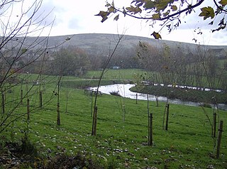
The River Jordan is a river in the county of Dorset, England. The river is approximately 3 miles (4.8 km) long, and includes the tributaries of the Osmington Brook and the Preston River. The River Jordan discharges into the English Channel at Bowleaze Cove, northeast of Weymouth.