Related Research Articles

Western Australia is a state occupying the entire western third of Australia. It is bounded by the Indian Ocean to the north and west, and the Southern Ocean to the south, the Northern Territory to the north-east, and South Australia to the south-east. Western Australia is Australia's largest state, with a total land area of 2,529,875 square kilometres, and the second-largest country subdivision in the world, surpassed only by Russia's Sakha Republic. The state has about 2.6 million inhabitants – around 11 percent of the national total – of whom the vast majority live in the south-west corner, 79 per cent of the population living in the Perth area, leaving the remainder of the state sparsely populated.

The Tropic of Capricorn is the circle of latitude that contains the subsolar point on the December solstice. It is thus the southernmost latitude where the Sun can be directly overhead. Its northern equivalent is the Tropic of Cancer.

A cash crop or profit crop is an agricultural crop which is grown to sell for profit. It is typically purchased by parties separate from a farm. The term is used to differentiate marketed crops from subsistence crops, which are those fed to the producer's own livestock or grown as food for the producer's family. In earlier times cash crops were usually only a small part of a farm's total yield, while today, especially in developed countries, almost all crops are mainly grown for revenue. In the least developed countries, cash crops are usually crops which attract demand in more developed nations, and hence have some export value.

Dryland farming and dry farming encompass specific agricultural techniques for the non-irrigated cultivation of crops. Dryland farming is associated with drylands, areas characterized by a cool wet season followed by a warm dry season. They are also associated with arid conditions, areas prone to drought and those having scarce water-resources.
Australia is a major agricultural producer and exporter, with over 325,300 employed in agriculture, forestry and fishing as of February 2015. Agriculture and its closely related sectors earn $155 billion-a-year for a 12% share of GDP. Farmers and graziers own 135,997 farms, covering 61% of Australia's landmass. Approximately 64% of all farms across Australia belong to the state, with a further 23% that are still owned by indigenous groups or tribes. Across the country there is a mix of irrigation and dry-land farming. Australia leads the world with 35 million hectares certified organic, which is 8.8% of Australia's agricultural land and Australia now accounts for more than half (51%) of the world's certified organic agriculture hectares. The CSIRO, the federal government agency for scientific research in Australia, has forecast that climate change will cause decreased precipitation over much of Australia and that this will exacerbate existing challenges to water availability and quality for agriculture.
Western Australia is divided into regions according to a number of systems.

The Wheatbelt is one of nine regions of Western Australia defined as administrative areas for the state's regional development, and a vernacular term for the area converted to agriculture during colonisation. It partially surrounds the Perth metropolitan area, extending north from Perth to the Mid West region, and east to the Goldfields-Esperance region. It is bordered to the south by the South West and Great Southern regions, and to the west by the Indian Ocean, the Perth metropolitan area, and the Peel region. Altogether, it has an area of 154,862 square kilometres (59,793 sq mi).

Narrogin is a large town in the Wheatbelt region of Western Australia, 192 kilometres (119 mi) southeast of Perth on the Great Southern Highway between Pingelly and Wagin. In the age of steam engines, Narrogin was one of the largest railway operation hubs in the southern part of Western Australia.

Cunderdin is a town located in the Wheatbelt region of Western Australia 156 km east of Perth, along the Great Eastern Highway. Due to it being on the route of the Goldfields Water Supply Scheme it is also on the Golden Pipeline Heritage Trail. It is a rural community consisting of a district high school and an agricultural college.

Kimba is a rural service town on the Eyre Highway at the top of Eyre Peninsula in the Australian state of South Australia. At the 2016 census, Kimba had a population of 629 and it has an annual rainfall of 348 millimetres (13.7 in). There is an 8-metre (26 ft) tall statue of a galah beside the highway, marking halfway between the east and west coasts of Australia. The Gawler Ranges are north of the highway near the town.

Lake Grace is a town in the Eastern Wheatbelt region of Western Australia, 345 kilometres (214 mi) from Perth along State Route 107 between Wagin and Ravensthorpe. It is the main town in the Shire of Lake Grace. At the 2016 census, Lake Grace had a population of 507.
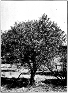
Santalum spicatum, the Australian sandalwood, is a tree native to semiarid areas at the edge of Southwest Australia. It is traded as sandalwood, and its valuable oil has been used as an aromatic, a medicine, and a food source. S. spicatum is one of four high-value Santalum species occurring in Australia.

Cowell is a coastal town on Franklin Harbor on the eastern side of the Eyre Peninsula, in South Australia on the Lincoln Highway 111 km south of the major town of Whyalla. It is 493 km by road from Adelaide.

Roughly one-third of Iran's total surface area is suited for farmland, but because of poor soil and lack of adequate water distribution in many areas, most of it is not under cultivation. Only 12% of the total land area is under cultivation but less than one-third of the cultivated area is irrigated; the rest is devoted to dryland farming. Some 92 percent of agricultural products depend on water. The western and northwestern portions of the country have the most fertile soils. Iran's food security index stands at around 96 percent.

Drought in Australia is defined by the Australian Bureau of Meteorology as rainfall over a three-month period being in the lowest decile of what has been recorded for that region in the past. This definition takes into account that drought is a relative term and rainfall deficiencies need to be compared to typical rainfall patterns including seasonal variations. Specifically, drought in Australia is defined in relation to a rainfall deficiency of pastoral leases and is determined by decile analysis applied to a certain area. Note that this definition uses rainfall only because long-term records are widely available across most of Australia. However, it does not take into account other variables that might be important for establishing surface water balance, such as evaporation and condensation.
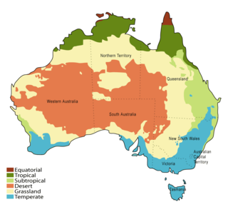
The Australian environment ranges from virtually pristine Antarctic territory and rainforests to degraded industrial areas of major cities. Forty distinct ecoregions have been identified across the Australian mainland and islands.
In Australia, the Federation Drought is the name given to a prolonged period of drought that occurred around the time of Federation in 1901.

Agriculture in Spain is important to the national economy.

Toolibin Lake is a seasonal fresh to brackish water perched lake or wooded swamp, in south-western Australia. The lake is contained with a 493-hectare (1,218-acre) nature reserve and it is located about 200 kilometres (124 mi) south-east of Perth, in the Shire of Narrogin, and 40 kilometres (25 mi) east of the town of Narrogin, in the Wheatbelt region of Western Australia. The lake is listed by the Australian Government as a threatened ecological community under the Environment Protection and Biodiversity Conservation Act 1999.

Agriculture is the main part of Tanzania's economy. As of 2016, Tanzania had over 44 million hectares of arable land with only 33 percent of this amount in cultivation. Almost 70 percent of the poor population live in rural areas, and almost all of them are involved in the farming sector. Land is a vital asset in ensuring food security, and among the nine main food crops in Tanzania are maize, sorghum, millet, rice, wheat, beans, cassava, potatoes, and bananas. The agricultural industry makes a large contribution to the country's foreign exchange earnings, with more than US$1 billion in earnings from cash crop exports.
References
- ↑ "Wheat Belt Regions of Australia". australiamyland.com.au. Retrieved 23 November 2016.
- ↑ "Climate and rainfall in the Australian Wheatbelt - Land Commodities". landcommodities.com. Retrieved 23 November 2016.
- ↑ "Farming Systems in the Australian Wheatbelt - Land Commodities". landcommodities.com. Retrieved 23 November 2016.