Related Research Articles

St. Clair County is a county located in the western portion of the U.S. state of Missouri. As of the 2020 census, the population was 9,284. Its county seat is Osceola. The largest city is Appleton City. The county was organized in 1841 and named after General Arthur St. Clair, Governor of the Northwest Territory. St. Clair was also the 9th president of the United States in Congress Assembled. Under his presidency, the Northwest Ordinance and United States Constitution were passed.

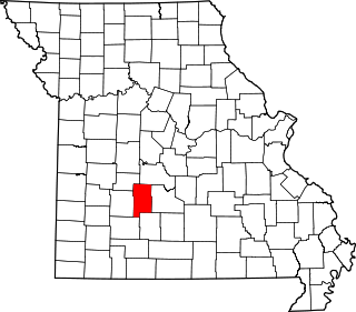
Hickory County is located in the U.S. state of Missouri. As of the 2020 census, the population was 8,279. Its county seat is Hermitage. The county was organized February 14, 1845, and named after President Andrew Jackson, whose nickname was "Old Hickory." The Pomme de Terre Dam, a Corps of Engineers facility, is located three miles south of Hermitage and forms Lake Pomme de Terre by damming the Pomme de Terre River and Lindley Creek. Truman Reservoir, also a Corps of Engineers facility, floods the Pomme de Terre Reservoir from the northern border of the county southward to the city limits of Hermitage.

Grundy County is a county located in the U.S. state of Missouri. As of the 2020 census, the population was 9,808. Its county seat is Trenton. The county was organized January 2, 1841, from part of Livingston County, Missouri and named after U.S. Attorney General Felix Grundy.

Greene County is located in the U.S. state of Missouri. As of the 2020 census, its population was 298,915. making it the fourth most-populous county in Missouri. Its county seat and most-populous city is Springfield. The county was organized in 1833 and is named after American Revolutionary War General Nathanael Greene.
Dallas County is a county located in the U.S. state of Missouri. As of the 2010 census, the population was 16,777. Its county seat is Buffalo. The county was organized in 1842 as Niangua County and then renamed in 1844 for George M. Dallas, who served as Vice President under James K. Polk.

Cole County is located in the central part of the U.S. state of Missouri. As of the 2020 census, its population was 77,279. Its county seat and largest city is Jefferson City, the state capital. The county was organized November 16, 1820 and named after pioneer William Temple Cole who built Cole's Fort in Boonville.
Benton County is a county located in the west central part of the U.S. state of Missouri. The population was 19,394 as of the 2020 Census. Its county seat is Warsaw. The county was organized January 3, 1835, and named for U.S. Senator Thomas Hart Benton of Missouri.

Brunswick is a city in Chariton County, Missouri, United States. Its population was 801 at the 2020 census. Brunswick, by official state proclamation, is the Pecan Capital of Missouri. The Missouri Farmers Association was founded in Brunswick in 1914.
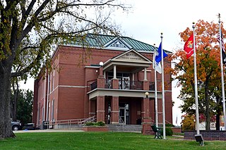
Hermitage is a city in Hickory County, Missouri, United States, on the Pomme de Terre River. The population was 621 at the 2020 census. It is the county seat of Hickory County. The John Siddles Williams House on Museum Street in Hermitage, on the National Register of Historic Places since 1980, houses the Hickory County Historical Society Museum and Research Room.

Wheatland is a city in Hickory County, Missouri, United States. The population was 277 at the 2020 census.
The Ladue School District is a public school district in Ladue, Missouri, with four elementary, one middle, and one high school, with a special Fifth Grade Center. The district serves 4,180 total students, and employs 280 full-time classroom teachers. The total operating revenue is $49.9 mil. with $50.2 mil. operating expenses. Ladue spends $11,903 per student, and pays an average of $62,697 per teacher ($41,000-$101,542). According to Newsweek, Ladue ranks in the top 2% of public schools in the nation. It serves an area encompassing 19 sq. mi. with more than 27,000 residents. It includes all or part of 10 communities including Ladue, Creve Coeur, Crystal Lake Park, Frontenac, Huntleigh, Olivette, Richmond Heights, Town and Country, Unincorporated St. Louis County, and Westwood.

The Springfield, Missouri, metropolitan area, as defined by the United States Census Bureau, is an area consisting of five counties in southwestern Missouri, anchored by the city of Springfield, the state's third largest city. Other primary population centers in the metro area include Nixa, Ozark, Republic, Bolivar, Marshfield and Willard. Currently, the city limits of Springfield reach the Nixa, and Ozark city limits at the Christian County line on US 160, and US 65 respectively, the city limits of Republic at James River Freeway on the southwest side of the city, and the Strafford city limits on Route 744 on the northeast side of the city.
Rockwood R-VI School District is a public school district headquartered in Eureka, Missouri, serving students in St. Louis County. The Rockwood School District is St. Louis County's largest public school system, serving 22,268 students.
The Wheatland–Chili Central School District in Scottsville, NY serves approximately 700 students in the village of Scottsville and portions of the towns of Chili, Wheatland, and Brighton in Monroe County and a portion of the town of Caledonia in Livingston County, with over 160 employees. It is the smallest school district in Monroe County.
Wheatland Township is an inactive township in Hickory County, in the U.S. state of Missouri.
Osage County R-II School District is a school district serving Osage County, Missouri. In the 2013-2014 school year Osage County R-2 School District spent $7,745 per student. The school district board governed State Technical College of Missouri until 1996 when it gained its own Board of Regents.
Linn High School is the only high school in Osage County R-II School District in Linn, Missouri. It is one of three high schools in Osage County, the other two being Chamois High School and Fatima High School.
Wheatland High School is a public high school located in Wheatland, Missouri.
Jefferson County R-VII School District is a school district located in Jefferson County, Missouri serving Festus, Missouri and Plattin, Missouri.
Montgomery Township is an inactive township in Hickory County, in the U.S. state of Missouri. It was named after Judge Joseph C. Montgomery.
References
- ↑ "Hickory County, MO". Hickory County Missouri. Retrieved 13 October 2018.
- 1 2 3 4 "Search for Public School Districts – District Detail for Wheatland R-II". National Center for Education Statistics . Institute of Education Sciences . Retrieved 13 Oct 2018.
- ↑ "Wheatland R-II School District". stltoday. Retrieved 13 October 2018.
- ↑ "Wheatland R-II school district". niche. Retrieved 13 October 2018.