White Deer, Texas

Last updated

White Deer, Texas
White Deer Texas 8-13-2011.jpg
Downtown White Deer
TXMap-doton-WhiteDeer.PNG
Location of White Deer, Texas
Carson County WhiteDeer.svg
Coordinates: 35°26′00″N101°10′30″W / 35.43333°N 101.17500°W / 35.43333; -101.17500
Country United States
State Texas
County Carson
Government
Area
[1]
  Total1.74 sq mi (4.51 km2)
  Land1.74 sq mi (4.51 km2)
  Water0.00 sq mi (0.00 km2)
Elevation
[2]
3,366 ft (1,026 m)
Population
 (2010)
  Total1,000
  Estimate 
(2019) [3]
955
  Density548.85/sq mi (211.94/km2)
Time zone UTC-6 (Central (CST))
  Summer (DST) UTC-5 (CDT)
ZIP code
79097
Area code 806
FIPS code 48-78316 [4]
GNIS feature ID2413477 [2]
Website www.whitedeer.us

White Deer is a town in Carson County, Texas, United States. The population was 1,000 at the 2010 census. [5] It is part of the Amarillo metropolitan statistical area.

Contents

Geography

White Deer is located along U.S. Highway 60 in east central Carson County, 13 miles (21 km) northeast of Panhandle, the Carson County seat, and 40 miles (64 km) northeast of Amarillo. [6]

According to the United States Census Bureau, the town has a total area of 1.7 square miles (4.5 km2), all land. [5]

Climate

According to the Köppen climate classification, White Deer has a semiarid climate, BSk on climate maps. [7]

History

The community was first settled around 1882, when the British-owned Francklyn Land and Cattle Company, later reorganized as the White Deer Land Company, occupied the area and began stocking it with cattle. [8] George Tyng, general manager of the property, built the headquarters for White Deer or Diamond F Ranch at the site in 1887. Around the same time, the Purcell Company purchased land in the vicinity as a right-of-way for the Southern Kansas Railway of Texas. A depot was built in 1888. The site was initially known as "Paton" (after John Paton), then "Whig", before being renamed White Deer in January 1899 – after nearby White Deer Creek. During the 1890s, British shareholders began selling land for small farms and ranches to settlers. The community moved to its present location near the railroad line in 1908. [6] A year later, Henry Czerner and Ben Urbanczyk established a community of Polish farmers from Central Texas at the northeastern edge of town. About 50 people were living in White Deer by 1910.

The discovery of oil and gas in Carson County in 1919 brought growth to White Deer and the surrounding area. The community incorporated in 1921, and the population had risen to 200 by the mid-1920s. At the peak of the oil boom in the late 1920s, White Deer was home to nearly 3,000 people. Soon after, the city experienced a period of decline. A disastrous fire in 1931, the negative economic impact of the Great Depression, and tornadoes in 1945 and 1951 were all contributing factors in White Deer's decline. In the late 1950s, the town became a shipping point for grain and cattle produced in the area. [8] [9] By 1980, the population was 1,210. That figure decreased to 1,125 in 1990 and 1,060 in 2000.

A statue of a white deer stands on a concrete pedestal in the middle of the town's main intersection. [8] At its base is a historical marker, erected in 1965, that commemorates the town's rich history. [9]

Demographics

Historical population
CensusPop.Note
1930 1,010
1940 733−27.4%
1950 629−14.2%
1960 1,05768.0%
1970 1,0923.3%
1980 1,21010.8%
1990 1,125−7.0%
2000 1,060−5.8%
2010 1,000−5.7%
2019 (est.)955 [3] −4.5%
U.S. Decennial Census [10]

2020 census

White Deer racial composition [11]
(NH = Non-Hispanic) [lower-alpha 1]
RaceNumberPercentage
White (NH)76283.01%
Black or African American (NH)10.11%
Native American or Alaska Native (NH)20.22%
Asian (NH)20.22%
Mixed/Multi-Racial (NH)636.86%
Hispanic or Latino 889.59%
Total918

As of the 2020 United States census, there were 918 people, 318 households, and 234 families residing in the town.

2000 census

As of the census [4] of 2000, 1,060 people, 425 households, and 311 families were residing in the town. The population density was 608.0 people/sq mi (235.2/km2). The 490 housing units had an average density of 281.1/sq mi (108.7/km2). The racial makeup of the town was 96.32% White, 0.85% Native American, 1.79% from other races, and 1.04% from two or more races. Hispanics or Latinos of any race were 5.28% of the population.

Of the 425 households, 32.9% had children under 18 living with them, 62.8% were married couples living together, 8.9% had a female householder with no husband present, and 26.8% were not families. About 25.9% of all households were made up of individuals, and 13.2% had someone living alone who was 65 or older. The average household size was 2.49, and the average family size was 3.01.

In the town, the age distribution was 27.0% under 18, 5.8% from 18 to 24, 28.2% from 25 to 44, 23.3% from 45 to 64, and 15.7% who were 65 or older. The median age was 38 years. For every 100 females, there were 93.1 males. For every 100 females age 18 and over, there were 89.2 males.

Estimated median household income in 2007 was $51,548 ($36,953 in 2000). Estimated median house value in 2007 was $88,886 ($48,400 in 2000). Mean prices in 2007 were: All housing units – $87,280; detached houses – $87,800; townhouses or other attached units – $61,183; mobile homes – $36,214; occupied boats, RVs, vans, etc. – $12,500.

Climate

White Deer-area historical tornado activity is slightly above Texas state average. It is 118% greater than the overall U.S. average. On June 8, 1995, an F4 (maximum wind speeds 207–260 mph) tornado 11.7 miles away from the White Deer town center injured seven people and caused between $5,000,000 and $50,000,000 in damages.[ citation needed ] On June 27, 1992, an F4 tornado 22.0 miles away from the town center injured seven people and caused between $5,000,000 and $50,000,000 in damages.[ citation needed ]

Education

Public education in White Deer is provided by the White Deer Independent School District. The district has an enrollment of around 400 students on two campuses, White Deer Elementary School] (grades Pre-K–8) and White Deer High School (grades 9–12).

Related Research Articles

<span class="mw-page-title-main">Carson County, Texas</span> County in Texas, United States

Carson County is a county located in the U.S. state of Texas. As of the 2020 census, its population was 5,807. The county seat is Panhandle. The county was founded in 1876 and later organized in 1888. It is named for Samuel Price Carson, the first secretary of state of the Republic of Texas.

<span class="mw-page-title-main">Gilbertville, Iowa</span> City in Iowa, United States

Gilbertville is a city in Black Hawk County, Iowa, United States. The population was 794 at the time of the 2020 census. It is part of the Waterloo–Cedar Falls Metropolitan Statistical Area.

<span class="mw-page-title-main">Fulton, Texas</span> Town in Texas, United States

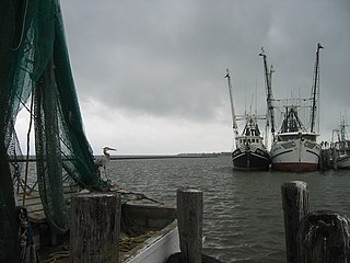
Fulton is a town in Aransas County, Texas, United States. As of the 2010 census, this South Texas coastal fishing community had a population of 1,358. The town is named for George Ware Fulton, a land developer in the area.

<span class="mw-page-title-main">Groom, Texas</span> Town in Texas, United States

Groom is a town in Carson County, Texas, United States. The population was 552 at the 2020 census. It is part of the Amarillo, Texas Metropolitan Statistical Area. It is on Interstate 40 42 miles (68 km) east of Amarillo and 215 miles (346 km) west of Oklahoma City.

<span class="mw-page-title-main">Panhandle, Texas</span> Town in Texas, United States

Panhandle is the county seat of Carson County, Texas, United States. The population of the town was 2,452 at the 2010 census. Panhandle is part of the Amarillo metropolitan statistical area.

<span class="mw-page-title-main">Skellytown, Texas</span> Town in Texas, United States

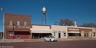
Skellytown is a town in Carson County, Texas, United States. Its population was 473 at the 2010 census, down from 610 at the 2000 census. Located in the Texas Panhandle, it is part of the Amarillo metropolitan area. In 1926, Skelly Oil Company purchased a 320-acre (130 ha) lease from Henry Schafer, a local rancher on whose land the Roxana oil pool was located. Schafer platted a new townsite, which he named "Skelly" in honor of the company's founder and president, William Grove Skelly of Tulsa, Oklahoma.

<span class="mw-page-title-main">Santa Anna, Texas</span> Town in Texas, United States

Santa Anna is a town in Coleman County in Central Texas, United States. Its population was 1,099 at the 2010 census.

<span class="mw-page-title-main">Clarendon, Texas</span> City in Texas, United States

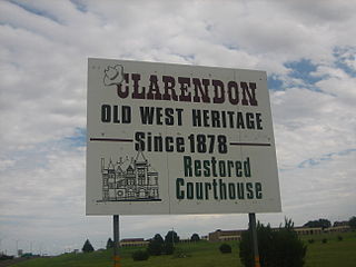
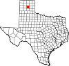
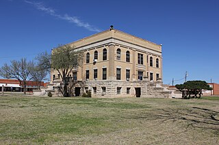
Clarendon is a city in Donley County, Texas, United States. Its population was 2,026 at the 2010 census. The county seat of Donley County, Clarendon is located on U.S. Highway 287 in the Texas Panhandle, 60 miles (97 km) east of Amarillo.

<span class="mw-page-title-main">Rocksprings, Texas</span> Town in Texas, United States

Rocksprings is a town in and the county seat of Edwards County, Texas, United States. As of the 2010 census, the town population was 1,182, down from 1,285 at the 2000 census. The town received its name from natural springs associated with the porous limestone rocks in the area.

<span class="mw-page-title-main">Crowell, Texas</span> City in Texas, United States

Crowell is a city in Foard County, Texas, United States. It serves as the county seat, and the population was 948 at the 2010 census, down from 1,141 at the 2000 census.

<span class="mw-page-title-main">Lefors, Texas</span> Town in Texas, United States

Lefors is a town in Gray County, Texas, United States. It is part of the Pampa, Texas micropolitan statistical area. Its population was 420 at the 2020 census.

<span class="mw-page-title-main">Pampa, Texas</span> City in Texas, United States

Pampa is a city in Gray County, Texas, United States. Its population was 16,867 as of the 2020 census. Pampa is the county seat of Gray County and is the principal city of the Pampa micropolitan statistical area, which includes both Gray and Roberts Counties. Pampa is named after the Pampas Lowlands in Argentina, Uruguay, and southern Brazil.

<span class="mw-page-title-main">Gruver, Texas</span> City in Texas, United States

Gruver is a city in Hansford County, Texas, United States. The population was 1,130 at the 2020 census. Farwell, in the center of Hansford County, approximately three miles east of what became Gruver, was established in 1880 by the Canott family of Illinois, and was the first town in the county. Gruver was established shortly after, and Farwell rapidly fell into oblivion after 1889, when it lost a county seat election to Hansford.

<span class="mw-page-title-main">Jacksboro, Texas</span> City in Texas, United States

Jacksboro is a city in Jack County, Texas, in the United States. Its population was 4,184 at the 2020 census. U.S. Highways 281 and 380, and Texas State Highways 114 and 199 intersect at Jacksboro, which is the county seat of Jack County.

<span class="mw-page-title-main">Lexington, Texas</span> Town in Texas, United States

Lexington is a town in Lee County, Texas, United States. Its population was 1,217 at the 2020 census. Lexington, a cattle trading town, is approximately 40 miles (64 km) west of Bryan.

<span class="mw-page-title-main">George West, Texas</span> City in Texas, United States

George West is a city in Live Oak County, Texas, United States, and named for cattle rancher George Washington West. The population was 2,445 at the 2010 census. It is the county seat of Live Oak County. George West was named the "storytelling capital of Texas" in 2005 by the Texas Senate; and it hosts the George West Storyfest, a festival that features storytelling, cowboy poetry, and music. Numerous ranches surround George West.

<span class="mw-page-title-main">Bowie, Texas</span> City in Montague County, Texas, US

Bowie is a town in Montague County, Texas, United States. The population was 5,218 at the 2010 census.

<span class="mw-page-title-main">Cactus, Texas</span> City in Texas, United States

Cactus is a city in Moore County, Texas, United States, located along U.S. Route 287. The population was 3,179 at the 2010 census.

<span class="mw-page-title-main">Cushing, Texas</span> City in Texas, United States

Cushing is a city in Nacogdoches County, Texas, United States. The population was 612 at the 2010 census.

<span class="mw-page-title-main">Happy, Texas</span> Town in Texas, United States

Happy is a town in Randall and Swisher Counties in the U.S. state of Texas. The population was 678 at the 2010 census. The Randall County portion of Happy is part of the Amarillo, Texas Metropolitan Statistical Area.

References

  1. "2019 U.S. Gazetteer Files". United States Census Bureau. Retrieved August 7, 2020.
  2. 1 2 U.S. Geological Survey Geographic Names Information System: White Deer, Texas
  3. 1 2 "Population and Housing Unit Estimates". United States Census Bureau. May 24, 2020. Retrieved May 27, 2020.
  4. 1 2 "U.S. Census website". United States Census Bureau . Retrieved January 31, 2008.
  5. 1 2 "Geographic Identifiers: 2010 Census Summary File 1 (G001): White Deer town, Texas". U.S. Census Bureau, American Factfinder. Archived from the original on February 13, 2020. Retrieved July 23, 2015.
  6. 1 2 "White Deer, Texas". Texas Escapes Online Magazine. Retrieved August 10, 2009.
  7. Climate Summary for White Deer, Texas
  8. 1 2 3 "White Deer, Texas". The Handbook of Texas online. Retrieved August 10, 2009.
  9. 1 2 "Carson County Historical Markers". Carson County, TX GenWeb. Retrieved August 10, 2009.
  10. "Census of Population and Housing". Census.gov. Retrieved June 4, 2015.
  11. "Explore Census Data". data.census.gov. Retrieved May 20, 2022.
  12. https://www.census.gov/ [ not specific enough to verify ]
  13. "About the Hispanic Population and its Origin". www.census.gov. Retrieved May 18, 2022.
  1. Note: the US Census treats Hispanic/Latino as an ethnic category. This table excludes Latinos from the racial categories and assigns them to a separate category. Hispanics/Latinos can be of any race. [12] [13]