
The Absaroka Range is a sub-range of the Rocky Mountains in the United States. The range stretches about 150 mi (240 km) across the Montana–Wyoming border, and 75 mi (120 km) at its widest, forming the eastern boundary of Yellowstone National Park along Paradise Valley, and the western side of the Bighorn Basin. The range borders the Beartooth Mountains to the north and the Wind River Range to the south. The northern edge of the range rests along I-90 and Livingston, Montana. The highest peak in the range is Francs Peak, located in Wyoming at 13,153 ft (4,009 m). There are 46 other peaks over 12,000 ft (3,700 m).

The Selway–Bitterroot Wilderness is a protected wilderness area in the states of Idaho and Montana, in the northwestern United States. At 1.3 million acres (5,300 km²), it is one of the largest designated wilderness areas in the United States.
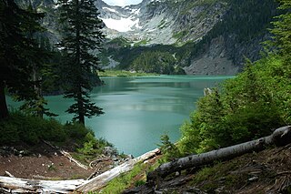
The Henry M. Jackson Wilderness is a 103,297-acre (41,803 ha) designated wilderness area in the state of Washington, United States. The area lies adjacent to the southwest corner of the Glacier Peak Wilderness, northwest of Stevens Pass on U.S. Highway 2 and northeast of the town of Skykomish, Washington. Wild Sky Wilderness is located immediately southwest of the Henry M. Jackson Wilderness. While the wilderness straddles the Cascade Mountain Range, most of it is in the westside ecotype. The wilderness lies in parts of Snoqualmie, Mount Baker, and Wenatchee national forests.

Bitterroot National Forest comprises 1.587 million acres (6,423 km2) in west-central Montana and eastern Idaho of the United States. It is located primarily in Ravalli County, Montana, but also has acreage in Idaho County, Idaho (29.24%), and Missoula County, Montana (0.49%).

The Anaconda–Pintler Wilderness is located in southwestern Montana, in the northwestern United States. It runs for 40 miles (64 km) along both sides of the crest of the Anaconda Range, covering almost 250 square miles (650 km2). To the north are the Sapphire Mountains, and to the south is the Big Hole Valley. Elevations range from about 5,000 feet (1,500 m) up to 10,793 feet (3,290 m) at West Goat Peak. West Pintler Peak, located in a more commonly visited area, rises to 9,894 feet (3,016 m). Visitors can most easily access this area via trailheads at Pintler Lake to the south, and at Lutz Creek and Moose Lake to the north. The wilderness lies in parts of Deer Lodge, Granite, Ravalli, and Beaverhead counties.

The Wilderness Act of 1964 was written by Howard Zahniser of The Wilderness Society. It created the legal definition of wilderness in the United States, and protected 9.1 million acres (37,000 km²) of federal land. The result of a long effort to protect federal wilderness and to create a formal mechanism for designating wilderness, the Wilderness Act was signed into law by President Lyndon B. Johnson on September 3, 1964 after over sixty drafts and eight years of work.

Goat Rocks Wilderness is a U.S. wilderness area in Washington, United States, comprising 108,096 acres (43,745 ha) of Okanagan–Wenatchee National Forest and Gifford Pinchot National Forest on the crest of the Cascade Range south of U.S. Highway 12. Its central feature is a number of rugged peaks, the Goat Rocks, that are named after the numerous mountain goats that live in the area.

Glacier Peak Wilderness is a 566,057-acre (229,075 ha), 35-mile-long (56 km), 20-mile-wide (32 km) wilderness area located within portions of Chelan, Snohomish, and Skagit counties in the North Cascades of Washington. The area lies within parts of Wenatchee National Forest and Mount Baker National Forest and is characterized by heavily forested stream courses, steep-sided valleys, and dramatic glacier-crowned peaks. The dominant geologic feature of the area is 10,541-foot (3,213 m) Glacier Peak. It is the most remote major volcanic peak in the Cascade Range and has more active glaciers than any other place in the lower forty-eight states. Glacier Peak is a volcanic cone of basalt, pumice, and ash which erupted during periods of heavy glaciation.

The King Range is a mountain range of the Outer Northern California Coast Ranges System, located entirely within Humboldt County on the North Coast of California.
Colonel Bob Wilderness is a 11,855-acre (4,798 ha) protected area located in the southwest corner of Olympic National Forest in the state of Washington. It is named after 19th-century orator Robert Green Ingersoll. Lake Quinault lies about 15 miles to the west. Elevations in the wilderness vary from 300 to 4,509 feet above sea level. The highest elevation is an unnamed peak; the second-highest elevation is Colonel Bob Mountain at 4,492 feet. The wilderness is a temperate rain forest with annual rainfall greater than 150 inches (3,800 mm).

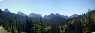
The William O. Douglas Wilderness is a designated wilderness in Central Washington. It includes 169,081 acres (68,425 ha) located between the U.S. Route 12 and State Route 410 and is jointly administered by the Okanogan-Wenatchee National Forest and the Gifford Pinchot National Forest. It shares a boundary with the Mount Rainier National Park on the west; Norse Peak Wilderness lies to the north, Goat Rocks Wilderness to the south. Approximately 25 miles (40 km) of the Pacific Crest Trail travel along the Cascade Range crest within its boundaries. It contains scattered peaks, sharp ridges, steep slopes and hundreds of small lakes and potholes. Much of the wilderness is drained by tributaries of the Naches River.

The Bull of the Woods Wilderness is a wilderness area located in the Mount Hood National Forest in the northwestern Cascades of Oregon, United States. It was created in 1984 and consists of 37,607 acres (15,219 ha) including prime low-elevation old-growth forest, about a dozen lakes of at least 1-acre (4,000 m2) and many large creeks and streams. Adjacent areas, including Opal Creek Wilderness to the west, create a pristine area of nearly 84 square miles (218 km2). There are seven trails that access the wilderness area with an additional seven trails within the protection boundaries themselves. Combined the system provides 75 miles (121 km) of challenging terrain for both pedestrian and equestrian recreation. The name of the peak and thus the wilderness area comes from logging jargon in which the "bull of the woods" was the most experienced logging foreman in an operation.
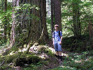
The Trapper Creek Wilderness is a designated wilderness consisting of 5,969 acres (2,416 ha) in the Gifford Pinchot National Forest in southern Washington. The wilderness covers nearly the entire Trapper Creek drainage and is the only pristine anadromous fish habitat in the Wind River watershed. The terrain is very steep and rugged and holds many streams and waterfalls—one as tall as 100 ft (30 m). It is one of the few sizeable blocks of low-elevation old-growth forest remaining in southern Washington.

The Wilderness Society is an American non-profit land conservation organization that is dedicated to protecting natural areas and federal public lands in the United States. They advocate for the designation of federal wilderness areas and other protective designations, such as for national monuments. They support balanced uses of public lands, and advocate for federal politicians to enact various land conservation and balanced land use proposals. The Wilderness Society also engages in a number of ancillary activities, including education and outreach, and hosts one of the most valuable collections of Ansel Adams photographs at their headquarters in Washington, D.C.
The Tatoosh Wilderness is a designated wilderness in the Gifford Pinchot National Forest in Washington in the Pacific Northwest region of the United States. The wilderness protects 15,725 acres (6,364 ha) managed by the U.S. Forest Service. It was officially designated as wilderness by Congress in 1984 to protect the scenic alpine environment that complements the adjacent Mount Rainier National Park. It features Tatoosh Peak, a member of the Tatoosh Range.
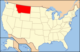
The following is an alphabetical list of articles related to the U.S. state of Montana.

Indian Heaven Wilderness is a protected area located inside the Gifford Pinchot National Forest of southwestern Washington state. The wilderness consists of 20,782 acres (8,410 ha) of broad, forested plateau, with meadows straddling numerous volcanic peaks and at least 150 small lakes, ponds, and marshes. The wilderness also contains the Indian Heaven volcanic field. Originally known to the Indians as "Sahalee Tyee," the area has been and remains culturally important to Native Americans. During the past 9,000 years, the Yakama, Klickitat, Cascades, Wasco, Wishram, and Umatilla tribes gathered in this area for berry picking, fishing, and hunting.
Wonder Mountain Wilderness is a designated wilderness area encompassing Wonder Mountain in the Olympic National Forest on the Olympic Peninsula of Washington in the United States. The wilderness comprises 2,349 acres (951 ha) bordering Olympic National Park and administered by the U.S. Forest Service.

Woodchute Wilderness is a 5,923-acre wilderness area in Prescott National Forest in the U.S. state of Arizona. It is about 4 miles (6.4 km) west of the town of Jerome. Elevation within the area, on the flanks of Woodchute Mountain, ranges from 5,500 to 7,800 feet. A chute on the north side of the mountain helped transport wood to historic Jerome.

Saddle Peak Hills Wilderness is the smallest designated wilderness area created by the California Desert Protection Act of 1994.