Williams, Lawrence County, Indiana

Last updated

Williams, Indiana
Lawrence County Indiana Incorporated and Unincorporated areas Williams Highlighted 1884338.svg
Location in Lawrence County, Indiana
Coordinates: 38°48′48″N86°39′05″W / 38.81333°N 86.65139°W / 38.81333; -86.65139
Country United States
State Indiana
County Lawrence
Township Spice Valley
Area
[1]
  Total3.58 sq mi (9.27 km2)
  Land3.58 sq mi (9.26 km2)
  Water0.00 sq mi (0.01 km2)
Elevation
[2]
538 ft (164 m)
Population
 (2020)
  Total229
  Density64.06/sq mi (24.73/km2)
ZIP code
47470
FIPS code 18-84338 [3]
GNIS feature ID2583476 [2]

Williams is an unincorporated community and census-designated place in Spice Valley Township, Lawrence County, Indiana, United States. As of the 2010 census, the population was 286. [4]

Contents

Williams is situated on the East Fork of the White River. Williams is home to Williams Dam, a hydroelectric dam that once powered the electricity for stone industries across southern Indiana, especially in nearby Bedford and Bloomington.

History

The Williams post office was established in 1876. [5] Byrd E. Williams was an early postmaster. [6] Williams was platted in 1889. [7] From 1910 to 1911, Williams Dam was being built on the East Fork of the White River. It was finally opened in 1913, giving electricity to stone industries in the region. The dam did this for almost four decades until being decommissioned in the 1950s. Almost 60 years later, Free Flow Power Corp., a startup company from Boston, looked into recommissioning the dam, giving the area a renewable energy power. The corporation planned to spend over $12 million by installing turbines on the plant. [8] [9] That plan was abandoned in 2018.

Geography

Williams is located in western Lawrence County in the northern part of Spice Valley Township. The census-designated place contains the town center of Williams along Indiana State Road 450, just north of the East Fork of the White River, but includes rural land to the north, east, and west. The CDP extends east to Crooked Creek, west to Dillman Road, and north to a high-tension power line. According to the U.S. Census Bureau, the CDP has a total area of 3.6 square miles (9.3 km2), of which 2.01 acres (8,135 m2), or 0.09%, are water. [10]

Via SR 450, Williams is 11 miles (18 km) southwest of Bedford, the Lawrence county seat, and 22 miles (35 km) northeast of Loogootee.

Williams Bridge

The Williams Bridge, also known as the Lawrence County Bridge, was the longest double-span covered bridge open to traffic in Indiana. It crosses the East Fork of the White River, in Section 7, Township 4 North, and Range 2 West, 1 mile (1.6 km) southwest of Williams. This double-span Howe truss structure has a length of 373 feet (114 m), or 402 feet (123 m) including the 13-foot (4.0 m) overhang at each end, with a portal clearance 16 feet (4.9 m) wide by 12 feet 6 inches (3.81 m) high. Built in 1884 by Joseph J. Daniels, the bridge receives its name from the nearby town, which was named in honor of early settler Isaac Williams. Though no historical marker is present, the Williams Bridge was added to the National Register of Historic Places in 1981 and is listed as #14-47-02 in the 1989 World Guide.

The Williams Bridge was totally refurbished in 2013 but has remained closed to vehicular traffic since around September 20, 2010. The Medora Bridge at 434 feet (132 m), in Jackson County, remains the longest covered bridge in the state, but it was closed to all but pedestrian traffic in 1972.

Demographics

Historical population
CensusPop.Note
2010 286
2020 229−19.9%
U.S. Decennial Census [11]

Related Research Articles

<span class="mw-page-title-main">Lawrence County, Indiana</span> County in Indiana, United States

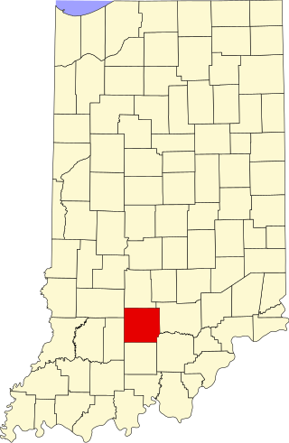
Lawrence County is a county located in the U.S. state of Indiana. As of 2020, the population was 45,011. The county seat is Bedford. Lawrence County comprises the Bedford, IN Micropolitan Statistical Area.

<span class="mw-page-title-main">Louisa, Kentucky</span> City in Kentucky, United States

Louisa is a home-rule class city located in eastern Kentucky at the merger of the Levisa and Tug Forks into the Big Sandy River, which forms part of the state's border with West Virginia. It is the seat of Lawrence County. The population was 2,467 at the 2010 census and an estimated 2,375 in 2018.

<span class="mw-page-title-main">Savage, Maryland</span> Census-designated place in Maryland, United States

Savage is an unincorporated community and census-designated place located in Howard County, Maryland, United States, approximately 18 miles (29 km) south of Baltimore and 21 miles (34 km) north of Washington, D.C. It is situated close to the city of Laurel and to the planned community of Columbia. As of the 2020 census, it had a population of 7,542. The former mill town is a registered historic place, and has several original buildings preserved within and around the Savage Mill Historic District.

<span class="mw-page-title-main">Adams Township, Carroll County, Indiana</span> Township in Indiana, United States

Adams Township is one of fourteen townships in Carroll County, Indiana. As of the 2010 census, its population was 516 and it contained 209 housing units.

<span class="mw-page-title-main">Eel River Township, Hendricks County, Indiana</span> Township in Indiana, United States

Eel River Township is one of twelve townships in Hendricks County, Indiana, United States. As of the 2010 census, its population was 1,662.

<span class="mw-page-title-main">Clay Township, Carroll County, Indiana</span> Township in Indiana, United States

Clay Township is one of fourteen townships in Carroll County, Indiana. As of the 2010 census, its population was 1,255 and it contained 463 housing units. Clay Township is part of the Rossville, Indiana school district.

<span class="mw-page-title-main">Wabash Township, Gibson County, Indiana</span> Township in Indiana, United States

Wabash Township is one of ten townships in Gibson County, Indiana, United States. As of the 2010 census, its population was 30 and it contained 27 housing units. Wabash Township has no organized seat within the township, as the only settlement is in two river camps Crawleyville and Jimtown. The township seat is Owensville, in Montgomery Township. This area is occasionally referred to as the "Tail of Gibson County", owing to its shape and position within the county. Nevertheless, the township is a panhandle of Gibson County, bordered by the Wabash River to the north, northwest, west, and in some parts, east, even southeast, and by Posey County to the south.

<span class="mw-page-title-main">Washington Township, Gibson County, Indiana</span> Township in Indiana, United States

Washington Township is one of ten townships in Gibson County, Indiana. As of the 2010 census, its population was 785 and it contained 345 housing units. Like Wabash Township, Washington Township also has no organized seat within the township, despite its two corporation-worthy towns Mount Olympus and Wheeling. Patoka, in White River Township, serves as the seat.

<span class="mw-page-title-main">Noblesville Township, Hamilton County, Indiana</span> Township in Indiana, United States

Noblesville Township is one of nine townships in Hamilton County, Indiana, United States. As of the 2010 census, its population was 50,564 and it contained 20,122 housing units.

<span class="mw-page-title-main">Guthrie Township, Lawrence County, Indiana</span> Township in Indiana, United States

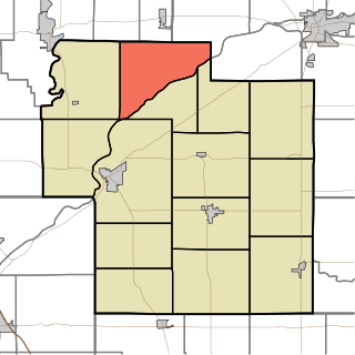
Guthrie Township is one of nine townships in Lawrence County, Indiana, United States. As of the 2010 census, its population was 1,383 and it contained 654 housing units.

<span class="mw-page-title-main">Indian Creek Township, Lawrence County, Indiana</span> Township in Indiana, United States

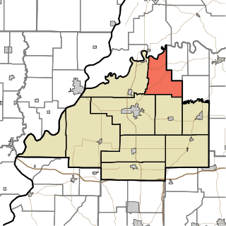
Indian Creek Township is one of nine townships in Lawrence County, Indiana, United States. As of the 2020 census, its population was 2,736 and it contained 1,176 housing units.

<span class="mw-page-title-main">Scipio, Indiana</span> Census-designated place in Indiana, United States

Scipio is an unincorporated community and census-designated place (CDP) in Geneva Township, Jennings County, Indiana, United States. As of the 2010 census it had a population of 153.

<span class="mw-page-title-main">Avoca, Indiana</span> Census-designated place in Indiana, United States

Avoca is an unincorporated community and census-designated place in Marshall Township, Lawrence County, Indiana, United States. As of the 2010 census the population was 583.

East Oolitic is an unincorporated community and census-designated place in Shawswick Township, Lawrence County, Indiana.

<span class="mw-page-title-main">Harrodsburg, Indiana</span> Census-designated place in Indiana, United States

Harrodsburg is an unincorporated community and census-designated place (CDP) in Clear Creek Township, Monroe County, in the U.S. state of Indiana. Its population was 656 at the 2020 census.

<span class="mw-page-title-main">Stanford, Indiana</span> Census-designated place in Indiana, United States

Stanford is an unincorporated community and census-designated place (CDP) in Van Buren Township, Monroe County, in the U.S. state of Indiana.

Mace is an unincorporated community and census-designated place (CDP) in Walnut Township, Montgomery County, in the U.S. state of Indiana.

<span class="mw-page-title-main">Williams Bridge</span> United States historic place

The Williams Bridge is a wooden covered bridge built in 1884 and is located in southern Indiana.

<span class="mw-page-title-main">Clendenin District, Mason County, West Virginia</span> Magisterial district in West Virginia, United States

Clendenin Magisterial District is one of ten magisterial districts in Mason County, West Virginia, United States. The district was originally established as a civil township in 1863, and converted into a magisterial district in 1872. In 2020, Clendenin District was home to 3,435 people.

Foxcliff Estates is an unincorporated community and census-designated place (CDP) in Washington Township, Morgan County, Indiana, United States. It was named a CDP after the 2020 census.

References

  1. "2020 U.S. Gazetteer Files". United States Census Bureau. Retrieved March 16, 2022.
  2. 1 2 U.S. Geological Survey Geographic Names Information System: Williams, Lawrence County, Indiana
  3. "U.S. Census website". United States Census Bureau . Retrieved January 31, 2008.
  4. "Profile of General Population and Housing Characteristics: 2010 Census Summary File 1 (DP-1), Williams CDP, Indiana". American FactFinder. U.S. Census Bureau. Archived from the original on February 13, 2020. Retrieved January 24, 2020.
  5. "Lawrence County". Jim Forte Postal History. Retrieved December 31, 2014.
  6. Baker, Ronald L. (October 1995). From Needmore to Prosperity: Hoosier Place Names in Folklore and History . Indiana University Press. p.  348. ISBN   978-0-253-32866-3. Byrd E. Williams became postmaster in 1900.
  7. History of Lawrence and Monroe Counties, Indiana: Their People, Industries, and Institutions. B.F. Bowen. 1914. pp.  206.
  8. History of Lawrence and Monroe Counties, Indiana: Their People, Industries, and Institutions. B.F. Bowen. 1914. pp.  57. williams indiana history.
  9. John Russell (December 29, 2013). "Indiana's Williams Dam could power up again". IndyStar . Retrieved February 5, 2018.
  10. "U.S. Gazetteer Files: 2019: Places: Indiana". U.S. Census Bureau Geography Division. Retrieved January 24, 2020.
  11. "Census of Population and Housing". Census.gov. Retrieved June 4, 2016.