Margaret is a city in St. Clair County, Alabama, United States. At the 2020 census, the population was 5,106. As of the 2010 census, the population is 4,428, an increase of 278.8%. Margaret incorporated in 1960 and became a city in October 2011.

St. Leon or Saint Leon is a town in Kelso Township, Dearborn County, Indiana, United States. The population was 678 at the 2010 census.

St. Paul or Saint Paul is a small town on the border of Decatur and Shelby counties in the U.S. state of Indiana. The population was 1,031 at the 2010 census.

Castle Hill is a town in Aroostook County, Maine, United States. The population was 373 people at the 2020 census.

Baldwin is a town in Cumberland County, Maine, United States. The population was 1,520 at the 2020 census. It is part of the Portland–South Portland–Biddeford, Maine, metropolitan statistical area.
Bradford is a town in Penobscot County, Maine, United States. It is part of the Bangor, Maine Metropolitan Statistical Area. The population was 1,184 at the 2020 census.
Ripley is a town in Somerset County, Maine, United States. The community was named after Brigadier General Eleazer Wheelock Ripley of the War of 1812. The population was 484 at the 2020 census.

Cherryfield is a town in Washington County, Maine, United States on the Narraguagus River. It was named for the wild cherries that once peppered the banks of the river. The town population was 1,107 at the 2020 census. The town bills itself as the "Blueberry Capital of the World". Roughly 75 acres (300,000 m2) on both sides of the river are a historic district on the National Register of Historic Places known as the Cherryfield Historic District. This district comprises a collection of period structures dating from c. 1750–1890. The town was first settled about 1760. In 1826,the part of Steuben known as Narraguagus was annexed onto Cherryfield.
Meddybemps is a town in Washington County, Maine, United States. The population was 139 at the 2020 census.

Bradley is a town in Grady County, Oklahoma, United States. The population was 78 at the 2020 United States census.

Leon is a town in Mason County, West Virginia, United States, situated along the Kanawha River. The population was 137 at the 2020 census. It is part of the Point Pleasant, WV–OH Micropolitan Statistical Area.

Reedy is a town in Roane County, West Virginia, United States. The population was 152 at the 2020 census.
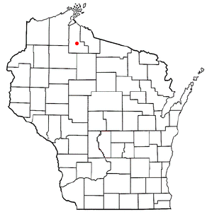
Morse is a town in Ashland County in the U.S. state of Wisconsin. The population was 493 at the 2010 census. The unincorporated communities of Ballou, Cayuga, Foster Junction, and Penokee are located in the town.

Hoard is a town in Clark County in the U.S. state of Wisconsin. The population was 594 at the 2000 census.

Freeman is a town in Crawford County, Wisconsin, United States. The population was 719 at the 2000 census. The villages of Ferryville and De Soto are located in the town. The unincorporated community of Reed is also located in the town.

Gardner is a town in Door County, Wisconsin, United States. The population was 1,197 at the 2000 census. The unincorporated community of Little Sturgeon is located in the town.

The Town of Texas is located in Marathon County, Wisconsin, United States. It is part of the Wausau, Wisconsin Metropolitan Statistical Area. The population was 1,615 at the 2010 census. The unincorporated community of Granite Heights is located in the town.

Dakota is a town, as well as an unincorporated community in Waushara County, Wisconsin, United States. The town took its name from the community of the same name, which was platted for the community's first postmaster, Chapin M. Seeley, in 1853. It was likely named for the Dakota Territory which was in the news at the time. The unincorporated community of Bannerman is also located in the town. Bannerman was originally named Bannerman Junction in 1901 as a stop on the Chicago & Northwestern Railroad. It was named for William and John Bannerman, two Scottish men who owned the area's granite company.

Rose is a town in Waushara County, Wisconsin, United States. The population was 595 at the 2000 census. The unincorporated community of Heffron is located partially in the town.
Platteville is a town in Grant County, Wisconsin, United States. The population was 1,513 at the 2020 census. The city of Platteville is within the town, but is politically independent.