Pangborn Memorial Airport is in Douglas County, Washington, four miles east of Wenatchee, a city in Chelan County. The airport is owned by the Ports of Chelan and Douglas Counties.
Lancaster Regional Airport is two miles south of Lancaster, in Dallas County, Texas. Formerly Lancaster Airport, the National Plan of Integrated Airport Systems for 2011–2015 categorized it as a general aviation reliever airport.

Pompano Beach Airpark is a public airport located one mile (1.6 km) northeast of the central business district of Pompano Beach, in Broward County, Florida, United States. This airport is publicly owned by the City of Pompano Beach.

John C. Tune Airport is a public airport located in the western portion of the city of Nashville in Davidson County, Tennessee, United States. It is owned by the Metropolitan Nashville Airport Authority, located approximately one mile off of Briley Parkway in the Cockrill Bend area. It is a Class D airport.
Iowa City Municipal Airport, is two miles southwest of downtown Iowa City, in Johnson County, Iowa. It is the oldest civil airport west of the Mississippi River still in its original location.

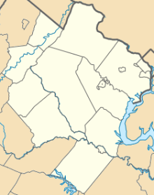
Manassas Regional Airport is five miles southwest of the center of Manassas. Manassas Regional Airport is the largest regional airport in Virginia, and it is located 30 miles (48 km) from Washington, D.C.
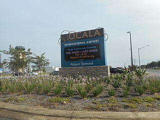
Ocala International Airport is five miles west of Ocala, in Marion County, Florida. It is also known as Ocala International Airport-Jim Taylor Field and was previously Ocala Regional Airport or Jim Taylor Field.
Chesapeake Regional Airport is a public use airport located in the city of Chesapeake, Virginia and serving the Hampton Roads area. The airport is 12 nautical miles (22 km) south of the central business district of Norfolk, Virginia. It is owned by the Chesapeake Airport Authority. Horizon Aviation is the FBO. Epix Aviation is also located on site.
Gaylord Regional Airport is a county-owned, public-use airport located one nautical mile (2 km) southwest of the central business district of Gaylord, a city in Otsego County, Michigan, United States. It is included in the Federal Aviation Administration (FAA) National Plan of Integrated Airport Systems for 2017–2021, in which it is categorized as a local general aviation facility.
Council Bluffs Municipal Airport is a public use airport located four nautical miles east of the central business district of Council Bluffs, a city in Pottawattamie County, Iowa, United States. It is owned by Council Bluffs Airport Authority. This airport is included in the National Plan of Integrated Airport Systems for 2011–2015, which categorized it as a general aviation facility.

Saline County Regional Airport is a county-owned, public-use airport located five nautical miles east of the central business district of Benton, a city in Saline County, Arkansas, United States. The airport's address is 1100 Hill Farm Road in Bryant, Arkansas. It is included in the FAA's National Plan of Integrated Airport Systems for 2011–2015, which categorized it as a general aviation facility.
Winchester Municipal Airport is a city-owned public-use airport located three nautical miles southeast of the central business district of Winchester, a city in Franklin County, Tennessee, United States.
Arthur N. Neu Airport is a public airport five miles southeast of Carroll, in Carroll County, Iowa. Also known as Arthur N. Neu Municipal Airport, it was established at its current location in the 1940s.
Harry Stern Airport is a public use airport in Richland County, North Dakota, United States. It is located one nautical mile (1.85 km) south of the central business district of Wahpeton, North Dakota and owned by the Wahpeton Airport Authority.
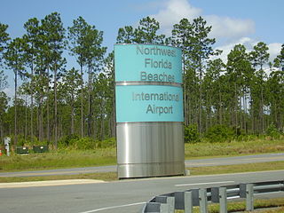
Northwest Florida Beaches International Airport is a public airport 18 miles (29 km) northwest of Panama City, Florida, United States, in Bay County. The airport is owned by the Panama City-Bay County Airport & Industrial District, and is north of Panama City Beach, near West Bay. It replaced Panama City–Bay County International Airport, which was located in Panama City.
Blue Ridge Regional Airport is nine miles southwest of Martinsville, in Henry County, Virginia. It is owned by the Blue Ridge Airport Authority. The FAA's National Plan of Integrated Airport Systems for 2009–2013 categorized it as a general aviation facility.
Comanche County–City Airport is a public use airport located two nautical miles northeast of the central business district of Comanche, a city in Comanche County, Texas, United States. It is owned by the City of Comanche and Comanche County. The airport is included in the FAA's National Plan of Integrated Airport Systems for 2011–2015, which categorized it as a general aviation facility.
Necedah Airport is a public use airport located one nautical mile (2 km) northwest of the central business district of Necedah, a village in Juneau County, Wisconsin, United States. It is owned by the Village of Necedah.
Carlisle Airport (Pennsylvania) (IATA: N94, ICAO: None, FAA LID: N94) is a publicly-owned, public use airport located one nautical miles (two mi, three km) southeast of the central business district of Carlisle, a city in Cumberland County, Pennsylvania, United States. This airport is owned and operated by South Middleton Township, Cumberland County, Pennsylvania.
Grinnell Regional Airport, known locally as Billy Robinson Field, is a city-owned public-use airport located one mile (1.6 km) south of the central business district of Grinnell, a city in Poweshiek County, Iowa, United States. It is included in the National Plan of Integrated Airport Systems for 2017–2021, which categorized it as a local general aviation facility.