Wingate, North Carolina

Last updated

Wingate, North Carolina
Wingate, NC Town Hall IMG 4253.JPG
Wingate Town Hall
NCMap-doton-Wingate.PNG
Location of Wingate, North Carolina
Coordinates: 34°59′09″N80°26′53″W / 34.98583°N 80.44806°W / 34.98583; -80.44806
Country United States
State North Carolina
County Union
Incorporated1901
Named for Washington M. Wingate [1]
Area
[2]
  Total2.25 sq mi (5.83 km2)
  Land2.23 sq mi (5.78 km2)
  Water0.02 sq mi (0.05 km2)
Elevation
[3]
581 ft (177 m)
Population
 (2020)
  Total4,055
  Density1,816.76/sq mi (701.61/km2)
Time zone UTC-5 (Eastern (EST))
  Summer (DST) UTC-4 (EDT)
ZIP code
28174
Area code 704
FIPS code 37-74760 [4]
GNIS feature ID2406902 [3]
Website www.townofwingatenc.gov
The Jesse Helms Center, which honors the late U.S. Senator Jesse Helms, who served from 1973 to 2003, is located next to the Wingate Town Hall. Jesse Helms Center, Wingate, NC IMG 4252.JPG
The Jesse Helms Center, which honors the late U.S. Senator Jesse Helms, who served from 1973 to 2003, is located next to the Wingate Town Hall.

Wingate is a town in Union County, North Carolina, United States. The population was 3,491 at the 2010 census.

Contents

History

The Wingate Commercial Historic District was listed on the National Register of Historic Places in 2014. [5] It is named for Washington Manly Wingate.

Geography

According to the United States Census Bureau, the town has a total area of 1.7 square miles (4.4 km2), all land.

Wingate is drained by tributaries to Richardson Creek, including Rays Fork and Meadow Branch.

Demographics

Historical population
CensusPop.Note
1910 353
1920 47033.1%
1930 52611.9%
1940 5412.9%
1950 79346.6%
1960 1,30464.4%
1970 2,56997.0%
1980 2,6151.8%
1990 2,8217.9%
2000 2,406−14.7%
2010 3,49145.1%
2020 4,05516.2%
U.S. Decennial Census [6]

2020 census

Wingate racial composition [7]
RaceNumberPercentage
White (non-Hispanic)1,92447.45%
Black or African American (non-Hispanic)1,31532.43%
Native American 80.2%
Asian 611.5%
Pacific Islander 20.05%
Other/Mixed 1954.81%
Hispanic or Latino 55013.56%

As of the 2020 United States census, there were 4,055 people, 1,002 households, and 693 families residing in the town.

2000 census

As of the census [4] of 2000, there were 2,406 people, 751 households, and 464 families residing in the town. The population density was 1,430.2 inhabitants per square mile (552.2/km2). There were 825 housing units at an average density of 490.4 per square mile (189.3/km2). The racial makeup of the town was 60.6% White, 28.8% African American, 0.4% Native American, 0.9% Asian, 7.9% from other races, and 1.4% from two or more races. Hispanic or Latino of any race were 12.4% of the population.

There were 751 households, out of which 30.0% had children under the age of 18 living with them, 41.0% were married couples living together, 17.2% had a female householder with no husband present, and 38.1% were non-families. 27.4% of all households were made up of individuals, and 12.5% had someone living alone who was 65 years of age or older. The average household size was 2.46 and the average family size was 2.99.

In the town, the population was spread out, with 18.7% under the age of 18, 35.0% from 18 to 24, 21.7% from 25 to 44, 15.6% from 45 to 64, and 8.9% who were 65 years of age or older. The median age was 23 years. For every 100 females there were 93.9 males. For every 100 females age 18 and over, there were 93.0 males.

The median income for a household in the town was $33,750, and the median income for a family was $45,250. Males had a median income of $33,173 versus $22,708 for females. The per capita income for the town was $13,884. About 13.8% of families and 20.0% of the population were below the poverty line, including 20.9% of those under age 18 and 21.0% of those age 65 or over.

The town is known mainly for Wingate University and the Jesse Helms Center, K-Ci & JoJo and Walter Collin Burleson.

Related Research Articles

<span class="mw-page-title-main">Ulen, Indiana</span> Town in Indiana, United States

Ulen is a town in Center Township, Boone County, in the U.S. state of Indiana. The population was 117 at the 2010 census. The town is surrounded by the city of Lebanon.

<span class="mw-page-title-main">Wingate, Indiana</span> Town in Indiana, United States

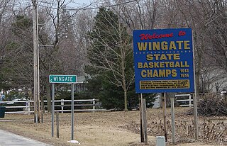
Wingate, formerly known as "Pleasant Hill", is a town in Coal Creek Township, Montgomery County, in the U.S. state of Indiana. The population was 237 at the 2020 census.

<span class="mw-page-title-main">Simmesport, Louisiana</span> Town in Louisiana, United States

Simmesport is a town in Avoyelles Parish, Louisiana, United States. The population was 2,161 at the 2010 census. It is the northernmost town on the Atchafalaya River, located near the Old River which connects the Red and Atchafalaya rivers with the Mississippi River.

<span class="mw-page-title-main">Eagle Lake, Maine</span> Town in the state of Maine, United States

Eagle Lake is a town in Aroostook County, Maine, United States. The population was 772 at the 2020 census. The town was named by a body of troops heading from Bangor to the Aroostook War for the many eagles that they saw around the lake. A total of 49.0% of the population speaks French, reflecting a trend in Northeastern Maine.

Bradley is a town in Penobscot County, Maine, United States. It is part of the Bangor Metropolitan Statistical Area. The population was 1,532 at the 2020 census. The village of Bradley is in the northwestern corner of the town.

<span class="mw-page-title-main">Clear Spring, Maryland</span> Town in Maryland, United States

Clear Spring is a town in Washington County, Maryland, United States. The population was 358 at the 2010 census.

<span class="mw-page-title-main">Richland, Michigan</span> Village in Michigan, United States

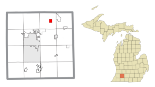
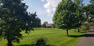
Richland is a village in Kalamazoo County in the U.S. state of Michigan. The population was 751 at the 2010 census, up from 593 at the 2000 census.

Newton Township is a township in Otter Tail County, Minnesota, United States. The population was 751 at the 2000 census.

Burnhamville Township is a township in Todd County, Minnesota, United States. The population was 751 at the 2000 census. By the 2020 census the population had risen to 773.

<span class="mw-page-title-main">Grandview, Missouri</span> City in Missouri, United States

Grandview is a city in Jackson County, Missouri, United States. The population was 24,475 at the 2010 census. It is part of the Kansas City metropolitan area.

<span class="mw-page-title-main">Five Points, Warren County, Ohio</span> CDP in Ohio, United States

Five Points is a census-designated place (CDP) in Clearcreek Township, Warren County, Ohio, United States. The population was 2,247 at the 2020 census.

<span class="mw-page-title-main">Forward Township, Butler County, Pennsylvania</span> Township in Pennsylvania, United States

Forward Township is a township in Butler County, Pennsylvania, United States. The population was 3,164 at the 2020 census.

<span class="mw-page-title-main">Oil Creek Township, Venango County, Pennsylvania</span> Township in Pennsylvania, United States

Oil Creek Township is a township in Venango County, Pennsylvania, United States. The population was 751 at the 2020 census, a decrease from 854 in 2010, which was an increase over the 840 residents tabulated as of the 2000 census.

<span class="mw-page-title-main">Deemston, Pennsylvania</span> Borough in Pennsylvania, United States

Deemston is a borough in Washington County, Pennsylvania, United States and part of the Pittsburgh metropolitan area since 1950. The population was 751 at the 2020 census.

<span class="mw-page-title-main">Nottingham Township, Pennsylvania</span> Township in Pennsylvania, United States

Nottingham Township is a township in Washington County, Pennsylvania, United States. The population was 2,933 in the 2020 census.

<span class="mw-page-title-main">Bancroft, West Virginia</span> Town in West Virginia, United States

Bancroft is a town in Putnam County, West Virginia, United States, along the Kanawha River. The population was 389 at the 2020 census. It is part of the Huntington–Ashland metropolitan area.

<span class="mw-page-title-main">Pine Grove, West Virginia</span> Town in West Virginia, United States

Pine Grove is a town in Wetzel County, West Virginia, United States. The population was 363 at the 2020 census. The community was named for a grove of pine trees near the original town site.

<span class="mw-page-title-main">North Hills, West Virginia</span> Town in West Virginia, United States

North Hills is a town in Wood County, West Virginia, United States. It is a suburb of Parkersburg. The population was 837 at the 2020 census. North Hills was incorporated on February 15, 1979.

<span class="mw-page-title-main">Rio, Wisconsin</span> Village in Wisconsin, United States

Rio is a village in Columbia County, Wisconsin, United States. The population was 1,133 at the 2022 United States Census. It is part of the Madison Metropolitan Statistical Area. The village rests primarily in the town of Otsego. The Village of Rio calls itself "Camper Country USA" due to several campgrounds located near the village. Rio is halfway between Columbus and Portage on Highway 16.

<span class="mw-page-title-main">Combined Locks, Wisconsin</span> Village in Wisconsin, United States

Combined Locks is a village in Outagamie County, Wisconsin, United States. The population was 3,328 at the 2010 census.

References

  1. "History". Town of Wingate. Retrieved November 25, 2023.
  2. "ArcGIS REST Services Directory". United States Census Bureau. Retrieved September 20, 2022.
  3. 1 2 U.S. Geological Survey Geographic Names Information System: Wingate, North Carolina
  4. 1 2 "U.S. Census website". United States Census Bureau . Retrieved January 31, 2008.
  5. "National Register of Historic Places Listings". Weekly List of Actions Taken on Properties: 12/01/14 through 12/05/14. National Park Service. December 12, 2014.
  6. "Census of Population and Housing". Census.gov. Retrieved June 4, 2015.
  7. "Explore Census Data". data.census.gov. Retrieved December 21, 2021.